(alternatively Stowe Hill)
Parish: HARTEST
District Council: BABERGH
TL 829 537
Not open to the public
On the clayland plateau of Suffolk c. 14.5km (9mls) south of Bury St Edmunds, Stowehill (Grade II) is c. 1.6km (1ml) north of the village of Hartest, which lies in the valley of a tributary of the River Glem that flows south to join the River Stour. Stowehill was built in 1792 for James Harrington, a surgeon and officer in Nelson’s fleet, following his marriage to Harriet Pamplin, the daughter of John Plampin of Chadacre Hall. Harriet had become wealthy when she inherited her aunt’s estate at Stowe Hill, Lichfield, which is thought to have given rise to the name of the Suffolk house. By the time of the tithe apportionment of 1838 it was owned by the Revd Henry Mears (c. 1782–1855) and in 1871 it was home of John Maclean Lee, a retired merchant, who died four years later. Stowehill changed hands several times over the next eighty years before being bought by the celebrated sculptor Geoffrey Clarke and his sculptor wife Ethelwynne ‘Bill’. Their son Jonathan, also a renowned sculptor, inherited the property and in 2021 Stowehill was sold.
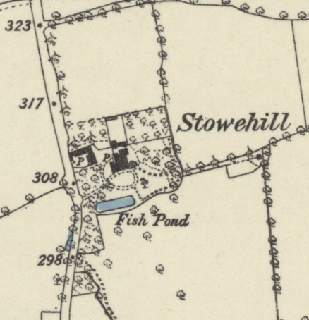
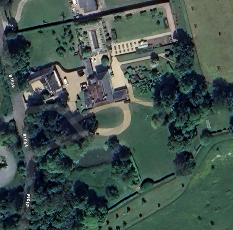
With views across the rolling landscape, the south-facing timbered-framed house today comprises a late-eighteenth century central two-storey block with glazed canopy on ornamental iron supports. The 1839 tithe map shows the house with additional wings to west and north, possibly added by the Revd Henry Mears. By 1884 further alterations had been made to the wings and an attached conservatory added to the east. More changes occurred over the following years, creating single-storey wings to east and west in the Gothic Revival style with an enlarged north wing created by the Clarkes.
The house site is named on Hodkinson’s 1783 map as ‘Folley’, a name usually given to an ornamental parkland feature, although which property it may have been associated with is unclear. The 1839 tithe map shows a site layout very similar to today, although the gardens have gradually expanded to the south since then. A surviving shelterbelt of trees, probably with late-eighteenth or early-nineteenth century origins, consists of mature yew, holm oak and chestnut and gives privacy to the house from the road to the west. Further surviving trees are shown on the tithe map to the east of the house with an avenue of trees leading through fields to a square building, probably a summerhouse. A building existed in this position into the twentieth century. The avenue has been supplemented by further planting to create a more densely planted strip of land with c. 10ha (25a) of parkland dotted with a number of mature lime and chestnut trees, some now paddocks, fanning out from this clump.
There are now c. 1.8ha (4.5a) of formal gardens. The basic shape of the circular drive to the south of the house is much as it was on the 1839 map. It passes through lawns dotted with trees. A rectangular pond parallel to the house measuring c. 45m (148ft) x 12m (39ft) lies beyond, which may have early origins as an ornamental canal connected to the ‘Folley’ marked on Hodskinson’s map. Lying west of the house, a late-eighteenth century coach house has been converted for residential use and now used as a holiday let.
A courtyard to the rear (north) of the house leads to a much-restored late-eighteenth or early-nineteenth century small walled garden centred on the house. This is shown on the tithe map with a lean-to glasshouse against the north wall facing south and named on the tithe apportionment as ‘Hot-house’ and ‘Green-house’. This has survived into the twentieth century. Built of 3.6m (12ft) high brick and flint walls, today it is home to a swimming pool and Italianate formal planting with another, larger walled garden attached to the east that is shown as a vegetable garden on the tithe map but by 1884 it had become an orchard. It has a tall north wall of brick and flint, a lower east wall giving views across the parkland and low south wall, possibly built in the late-twentieth or early-twenty-first century, separating the walled garden from the garden east of the house that has box topiary and formal planting.
SOURCES:
Babergh District Council, Hartest Conservation Area Appraisal, 2013.
Copinger, W. A., The Manors of Suffolk: The Hundreds of Babergh and Blackbourn, Vol. 1, 1905.
Cromwell, Thomas, K., Excursions in the County of Suffolk, Vol. 2, 1819.
Davy, David, Elisha, A Journal of Excursions through the County of Suffolk 1823-1844, published by Suffolk Records Society, 1982.
Dedham Vale Area and Stour Valley Project, ‘Explore the Glem Valley’ walk leaflet.
Kelly, E. R., Post Office Directory of Cambridgeshire, Norfolk & Suffolk, 1922.
Managing a Masterpiece: The Stour Valley Landscape Partnership, Historic Landscape Study Core Document, 2013.
Martin, Edward, ‘Garden Canals in Suffolk’ in East Anglia’s History: Studies in Honour of Norman Scarfe, 2002.
Strutt & Parker and David Burr, Sales Particulars, 2021.
https://suffolkartists.co.uk/index.cgi?choice=painter&pid=4231, Biography of Jonathan Clarke (accessed November 2021).
http://hartest.onesuffolk.net/assets/Neighbourhood-Plan/CharacterAssessment, 2017.pdf
East Anglian Daily Times ‘Manor house in 30 acres of Hartest countryside goes on market for £2.95m’, 6th May 2021, https://www.eadt.co.uk/lifestyle/21280205.manor-house-30-acres-hartest-countryside-goes-market-2-95m/ (accessed February 2022).
Census: 1841, 1851, 1871, 1881, 1891, 1901.
Maps:
1783 Hodskinson’s Map of Suffolk in 1783.
1839 (surveyed 1839) tithe map and apportionments.
1884 (surveyed 1884) OS map.
1905 (revised 1902) OS map.
1927 (revised 1924) OS map.
2024 Google aerial map (Imagery © Bluesky, CNES / Airbus, Getmapping plc, Infoterra Lts & Bluesky, Maxar Technologies, Map data © 2024).
Heritage Assets:
Stowehill (Grade II), Historic England No. 1036608.
Suffolk Record Office (now Suffolk Archives):
SRO (Bury St Edmunds) HD1707. Diary of Sarah Good, governess to the Bent family, of Stowe Hill, 1891–95.
Oxfordshire History Centre Hey/IX/iv/4, Assignment of terms in trust with reference to Revd Henry Mears formerly of Little Bookham, Surrey but now of Stowe Hill in Suffolk, 1839.
Site ownership: Private
Study written: March 2024
Type of Study: Desktop
Written by: Tina Ranft
Amended:
