(once known as Battlesea Hall)
Parish: STRADBROKE
District Council: MID SUFFOLK
TM 216 753
Not open to the public
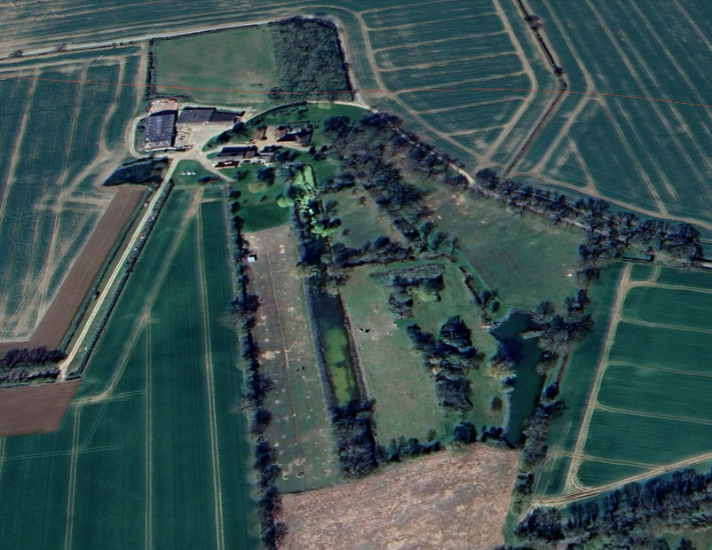
In an isolated position west of the dispersed settlement of the hamlet of Battlesea Green, The Rookery (Grade II), is 1.6km (1ml) north of Stradbroke village and c. 16km (10mls) north-west of Framlingham in area of heavy clay soils best known for its agriculture. It is in the north-west corner of the parish of Stradbroke, very close to the parish boundary with Hoxne and east of the road between the villages of Stradbroke and Hoxne. Battlesea Green hamlet lay near the western boundary of the former Battlesea Green that extended into the southern part of Wingfield parish. It is believed it was probably part of the c. 53.4ha (132a) that were enclosed under a private act of 1811 and awarded in 1813. The Rookery was once known as Battlesea Hall, which is the name used by Historic England for the listing of the property.
The house has a timber-framed seventeenth century main range and c. 1700 cross-wing, both built by the prominent Catholic Fox family when it was known as Battlesea Hall. Kirby’s 1736 map of Suffolk marks the house and the occupier as ‘Cap Fox’, presumably a military man of the rank captain, although there are no known records for this person. The Fox family were influential landowners in Stradbroke and the surrounding area and the names of a number of the family are inscribed on an altar-tomb in the churchyard of the medieval Church of All Saints (Grade II*) in Stradbroke. During the eighteenth century the attic of the house was used as a Roman Catholic chapel by the Fox family. Its remains are incorporated into the present house.
In 1778 it was bought with all its contents by the Henniker-Majors family of Thornham Magna who are believed to have taken the medieval retable (decorative panels behind the altar) from the chapel for use in Thornham Parva church (Grade I). The Henniker-Majors continued to own The Rookery throughout the nineteenth century when it was leased as a farmhouse.
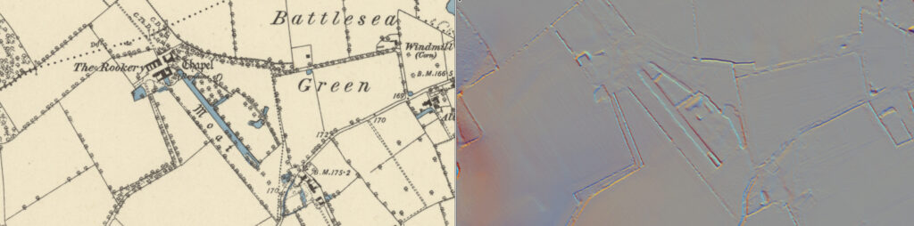
At the time of the tithe apportionment in 1840 the tenant farmer was John Gooch. The accompanying tithe map shows an area called ‘The Park’ and a field referred to as ‘Ploughed Park’ to the west of the house. This suggests they were part of a park attached to Battlesea Hall, rather than the extensive Stradbroke Park that was first recorded in the late-thirteenth century but seems to have been in existence for only a century. To the south were two fields, one called ‘Rookery’ and the other ‘Rookery Plough’, which relate to an area of woodland attached to the old Battlesea Green and shown on Hodskinson’s 1783 map of Suffolk before the green was enclosed in the early-nineteenth century.
At right-angles to the south front of the house the tithe map shows a surviving body of water that is Suffolk’s largest ornamental garden canal at c. 300m (984ft) long and c. 1.5m (5ft) deep. It tapers slightly from c. 14m (46ft) wide near the house to c. 17m (56ft) at its southern end with a surviving small wooded island. Although originally said to be part of a medieval moat system by Ordnance Survey and English Heritage, it has more recently been established as the western boundary of the former Battlesea Green. It has been suggested that the remains of the original small moat may have been incorporated into the canal complex. The map shows the garden of the house nestling between two arms at right-angles to the canal that link to a narrower, shorter parallel ‘canal’. Further south is an orchard. Canals were fashionable during the late-seventeenth and early-eighteenth centuries, which suggests the canals may have been built by Joseph Fox (d. 1747) who succeeded his father in 1697.
By 1861 Henry Chandler is recorded as the resident farming a substantial c. 81ha (200a). Later in the nineteenth century the Rush family worked the land and a William Rush (b. c. 1847) is registered as the occupier on the 1911 census. An additional wing was added to the farmhouse during this period and further alterations took place in the twentieth century.
The Rookery continues to be a farmhouse into the twenty-first century and the canal system has survived with a brick retaining wall at the north-west end of the longest canal rebuilt at the end of the twentieth century.
SOURCES:
Aston, Margaret, Broken Idols of the English Reformation, 2015.
Hoppitt, Rosemary, Deer Parks of Suffolk 1086–1602, 2020.
Martin, Edward, ‘Garden Canals in Suffolk’ in East Anglia’s History: Studies in Honour of Norman Scarfe, 2002.
Notes and Queries: A Medium of Inter-Communication for Literary Men, Artists, Antiquaries, Genealogists, Etc., April 28, 1855.
Suckling, Alfred, The History and Antiquities of the County of Suffolk, Vol. 1, 1846.
Suffolk Institute of Archaeology and Natural History Proceedings, Vol. 21, 1848.
Census: 1841, 1851, 1861, 1871, 1901, 1911.
Maps:
1736 Kirby’s Map of Suffolk
1783 Hodskinson’s Map of Suffolk in 1783.
1840 (surveyed 1840) tithe map and apportionments.
1885 (surveyed 1884) OS map.
1905 (revised 1903) OS map.
Heritage Assets:
Suffolk Historic Environment Record (SHER): SBK 010, SBK 015.
Battlesea Hall (Grade II), Historic England No: 1352168.
Church of All Saints (Grade II*), Historic England No: 1032854.
Church of St Mary (Grade I), Historic England No: 1285113.
Site ownership: Private
Study written: December 2025
Type of Study: Desktop
Written by: Tina Ranft
Amended:
