Parish: THEBERTON
District Council: EAST SUFFOLK (previously Suffolk Coastal)
TM 433 661
Not open to the public
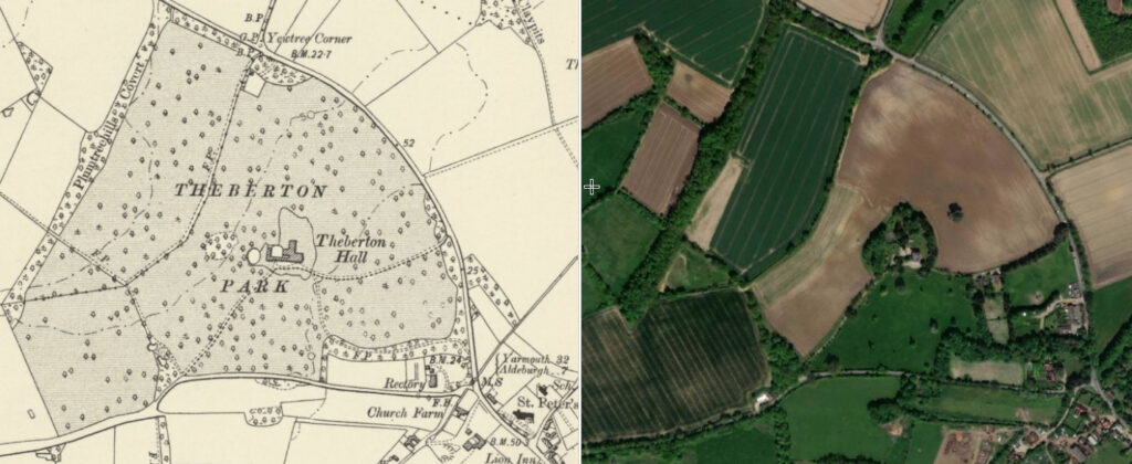
Close to the North Sea coast and south of the Minsmere River, the mainly agricultural parish of Theberton is c. 4km (2.5mls) north of Leiston and c. 40km (25mls) north-east of Ipswich. The parish includes a few scattered farmsteads, compact village and the small hamlet of Eastbridge, a bridging point of the Minsmere that flows eastward to the sea. The river formed the northern boundary of the Theberton Hall Estate and one of its tributaries flows through the parkland around Theberton Hall (Grade II). The house is north-west of Theberton village with St Peter’s Church (Grade I), which dates back to the medieval period, at its centre. The Hall replaced an earlier Tudor house on a different site, its whereabouts unknown. However, Henry Montague Doughty suggests in his Chronicles of Theberton, written in 1910, that pits and trenches in Kiln Grove south-west of the present house may indicate its foundations.
The soil is a variety of sand, gravel and clay at the indented edge of the central Suffolk clayland plateau that has been formed by rivers flowing east and south along the plateau edge. In 1810 an act was passed to enclose the low, common peat wetlands of the Minsmere River estuary, called the Minsmere Level, although it was not enacted until 1824. Part of the wetlands lay in the parish of Leiston. There followed a scheme of embankments and drainage which created the cultivated fields to the north-east of Theberton Hall that formed part of the Theberton Estate.
OWNERS AND OCCUPIERS
By the fifteenth century Theberton manor was owned by the Jenny family followed by John Fuller, William Bradley and John Ingham during the first half of the eighteenth century. It was George Doughty Esq. (d. 1798), owner of the manor from c. 1778, who built the present Theberton Hall in 1792. Originally from Leiston, George served as High Sheriff of Suffolk in 1793 and married Anne, daughter and heiress of John Goodwin of Martlesham Hall near Ipswich. The estate passed to their son the Revd George Clarke Doughty (b. 1768), vicar of Hoxne and rector of Denham and Martlesham, who was one of the instigators of the enclosure of the common wetlands of the nearby Minsmere estuary. George was married to Catharine, only daughter and heiress of Ezekiel Revett, Esq. The Revd Charles Montague Doughty (b. 1798) inherited the estate on his father’s death in 1832 and lived at the Hall with his wife Frederica, the third daughter of the Revd Frederick Hotham, rector of Donnington, and their family. On the death of the Revd Charles in 1850 the estate and manor passed to his first son Henry Montague (sometimes spelt Montagu) Doughty, Esq. J.P. (b. 1841), at the time only nine years old.
During much of the 1850s the house appears to have been unoccupied and at the time of the 1861 census Henry was only twenty years old and described as a ‘Landed Proprietor’ who was living in Kensington in London with his wife Edith Rebecca (b. c. 1842), the only daughter of D. Cameron Esq., the Chief Justice of Vancouver Island, and Henry’s younger brother Charles Montague (b. 1843), who like Henry spent the early part of his childhood at Theberton Hall. Charles went on to become a poet, explorer and the writer of the successful Travels in Arabia Deserta and other travel books. In the same year Theberton Hall was tenanted by John Eoy, Chief Constable of Police and family. Edith died in 1870, probably during the birth of their youngest son, and Henry was left a widower with five young children and living in London at the time of the 1871 census where there were four servants in residence. His children were Edith A. M. (born in Suffolk 1863), Catharine F. (born in Suffolk 1866), Gertrude (born in London 1867), Charles Hotham Montague (born in London 1869), Henry Montague (born in London 1870). The census transcription records the birthplace in Suffolk as ‘Thileston’. This would appear to be a mistranscription and refers to Theberton, suggesting Henry and his wife spent part of their time in Suffolk at the Theberton estate.
In 1872 Henry put the estate on the market, at the time a Mrs Scrivener was the tenant of the house, park and grounds with the shooting rights. It appears not to have sold and by 1881 Henry, now a practising barrister, had moved his family to Theberton, where he stayed until his death in 1916. The Theberton Hall Estate passed to his eldest son, Charles Hotham Montague, who had taken the additional name of Wylie when he married Lillian, the daughter of John Wylie Esq. in 1904. Charles and his younger brother Henry were both decorated military men. Charles died in 1915 during the Gallipoli campaign of World War I and Henry in 1921. The estate had passed to Charles’ wife Lillian and was once more for sale in 1921. The proceeds from the sale were said to be used to erect a memorial in Turkey to her husband and those who fell with him in Gallipoli. Around the same time the house and estate had been offered to Adelaide City Council, Australia, to commemorate the old friendship between the Doughty family and Col. William Light (1786–1839), founder of Adelaide, who at the age of six had been sent to Theberton Hall to be educated by George and Anne Doughty. However, the house lacked water, drainage, electricity or gas and was considered unfit for a modern home, so the offer was refused. The sale was unsuccessful and over the following years the house was left empty, although its game shoot continued to be held.
The military occupied the house and grounds during World War II and at the end of the war the estate was broken-up and the house and park were sold to a contractor who started to demolish the house and stables. It is believed he recouped the cost of buying the property when he cut down all the mature trees in the parkland and sold them for timber. Later additions to the house were the first to be demolished, leaving just the original main Georgian range standing when the Lynn-Allens, of nearby Scott’s Hall, noticed the grand staircase lying in the grounds. Intrigued, they viewed what was left of the house and decided to buy it from the contractor. Thus began forty years of restoration to make the house and grounds a comfortable family home, which the present owners continued after they bought the property in 1995.
THEBERTON HALL AND STABLE YARD
Built in 1792 of Suffolk white bricks with Caen stone dressings for George Doughty Esq., Theberton Hall was described by William White in his directory of 1844 as a ‘handsome brick mansion, in a small but wooded park.’
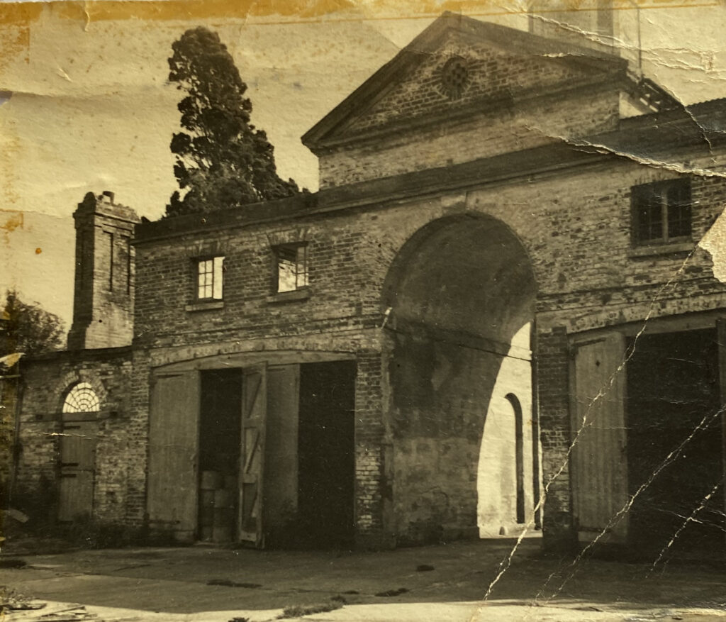
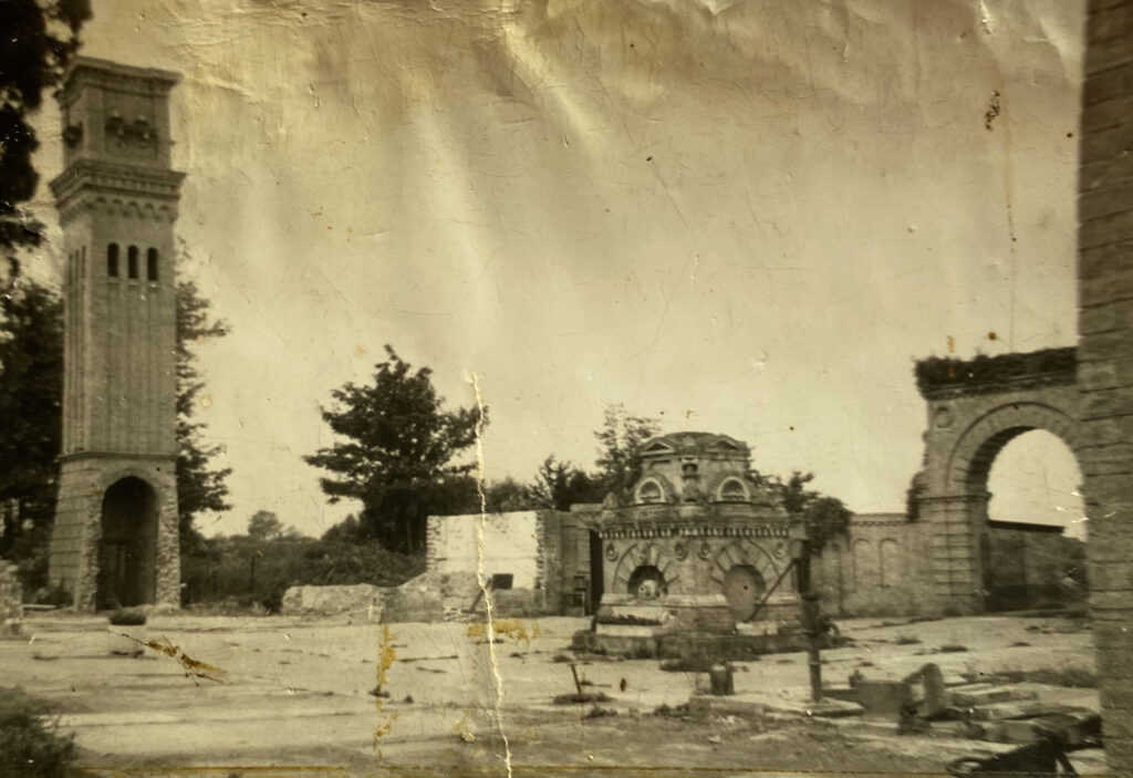
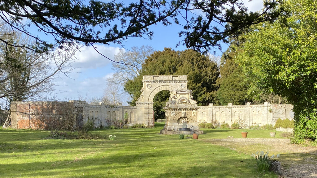
The map accompanying the 1838 tithe apportionment shows the main house range with two narrow west wings for servants accommodation and offices, such as the scullery, forming a courtyard that was open to the two-storey stable block courtyard (Grade II). This was created by an extension of the southern wing that turned northward for the two storey stable buildings. The main access into the courtyard was through an archway with a large clock tower above from the south. Mid-way along the courtyard’s northern side the map shows a square feature representing the large surviving well head. This comprises a square base with rusticated semi-circular arches to each face of the lower section and with cornice and pedimented upper section with fish motifs.
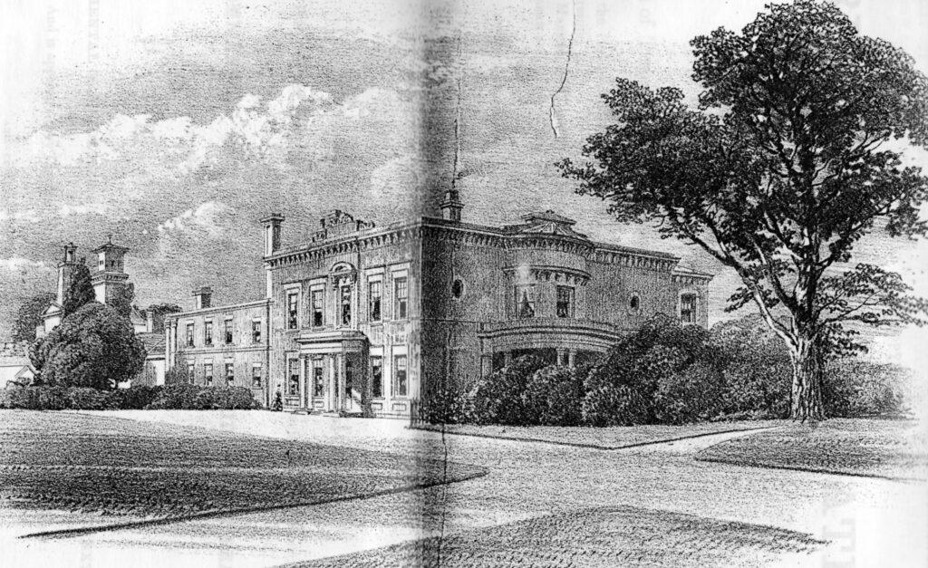
At about the time he was restoring and rebuilding the south aisle of Theberton parish church c. 1846 for the Revd Charles Doughty, the architect Lewis Nockalls Cottingham (1787–1847) was asked to suggest extensive alterations and additions to Theberton Hall. These were perhaps his last commissions as Lewis died in 1847. Only three years later the Revd Charles died before the full design could be realised. On inheriting Theberton from his father, the young Henry Montague Doughty continued the work to create a much-extended house in the Italian Renaissance style. However, sales particulars of 1872 make clear that Lewis Cottingham’s elaborate design was never fully implemented and the house remained unfinished. By this time a large wing had been added to the north of the original house containing a grand hall/picture gallery, library and range of master bedrooms and smaller apartments above. Later sales particulars refer to the grand hall as a ballroom.
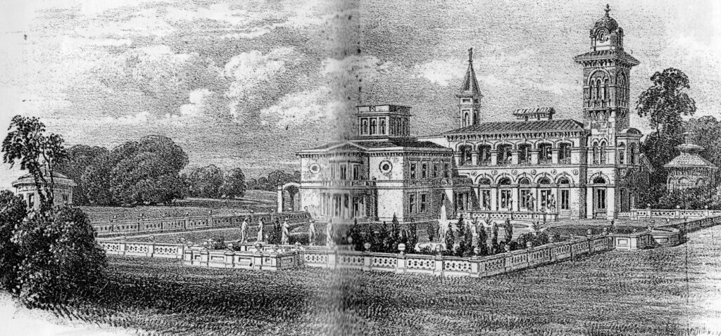
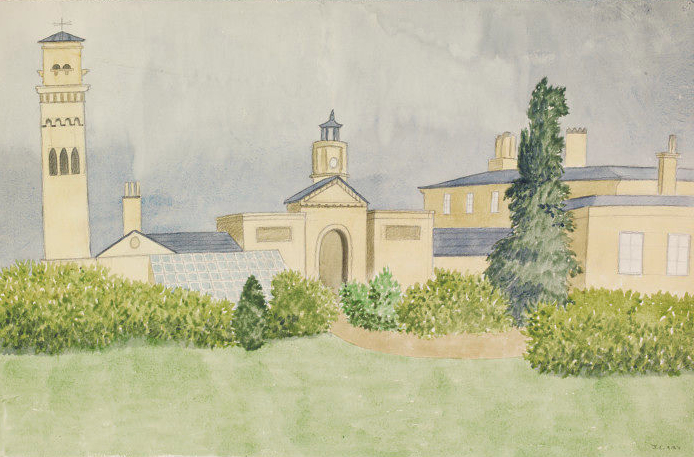
In 1852 alterations in the same Italian Renaissance style were made to the stable courtyard. A new curved wall with semi-circular arched entrance was built to the north, placing the well head at the centre of the yard. This was enclosed by a wall between the servants courtyard. Both north and south entrance gateways into the stable yard had ornamented gates. A doorway with rusticated surround was added in the western elevation. A brick and stone ornamental tower c. 18.2m (60ft) high was built attached to the yard’s south-west corner that was mentioned in the 1872 sales particulars and probably built at the same time as the alterations to the stable courtyard.
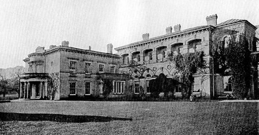
Most of the 1852 extension to the house is described in the sales particulars of 1921, although Historic England states that some of the additions were demolished in the 1920s, suggesting this occurred after the house and parkland failed to sell and lay empty for a number of years. After World War II most of the later additions were demolished to leave just the original 1792 wing of the house, although some of the interior had been removed. At the same time the tower and much of the stable courtyard, including the southern side and the first floor rooms, were also demolished. Since then the house has been restored and the remains of the stable courtyard stabilised and incorporated into the gardens surrounding the house.
THE PARK AND GARDENS
A deer park associated with Theberton Hall was first recorded in the early-sixteenth century. It was close to the northern parish boundary with Middleton and extended westward into the parish of Kelsale, thus including present day Theberton Woods. Although the park is not marked on Hodskinson’s 1783 map, a small park surrounding Theberton Hall is shown on the 1838 tithe map when it was the home of Revd Charles Montagu Doughty. The map shows the house and stable complex within an oval-shaped garden enclosure with a large oval pond to the west. There were drives between clumps of trees from the Leiston to Yoxford road to the east and from the south-west off present day Pretty Road. The south-west entrance arrived south of the house, having passed an entrance arch into the stable courtyard. The parkland extended north into the neighbouring parish, now Middleton-cum-Fordley, and to the south-east where, for privacy, a surviving shelterbelt of trees surrounds the Old Rectory (Grade II), which dates back to the fifteenth century. Sixteenth century Dovehouse Farm (Grade II) lies west of the house and is presumably the site of a dovecote, most likely associated with the earlier manor house. The estate included a number of woods and coverts and was known particularly for its shooting.
In 1844 the park was noted for being well wooded, and later sales particulars of 1872 describe it as a residential and manorial estate of 442ha (1,092a), including farms, cottages and small holdings, with a mansion with ‘commanding views’ including of the sea. At the time its park extended to 20.2ha (50a) with pleasure gardens and shrubbery walks of evergreen and flowering shrubs interspersed with trees. A kitchen garden extending to 0.4ha (1a) lay close to the stables. Although the house and park were tenanted, the woods and plantations were retained for the shooting by the Doughty family. The particulars feature an illustration of a keeper’s lodge. This was not located at the main entrances into the park but was a short distance to the west near Great Wood and a concentration of groves and coverts.
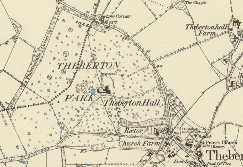
The park remained well-wooded with individual freestanding trees in 1883. The OS map of that year shows an additional drive leading to the rear of the stable courtyard from the north-east and a footpath through the shelterbelt of trees around the Old Rectory. By this time the clumps of trees beside the east entrance had expanded along the road to create a shelterbelt of trees. When the estate was for sale again in 1921 it had contracted to 280ha (691a) due to the sale of the lands to the east around Theberton Hall Farm. However, the parkland had expanded to 28.3ha (70a) and was still described as well-wooded. By this time the garden enclosure had expanded northward into the parkland so that it encircled the later north wing of the house.
With the break-up of the estate after World War II only the southern section of the park was retained, the northern section converted for agricultural use with the loss of many of the parkland trees and the northern drive. Most of the mature freestanding trees in the southern parkland were felled after World War II. The parkland further contracted when industrial units were built north of the Old Rectory with a few bungalows constructed beside the eastern driveway.
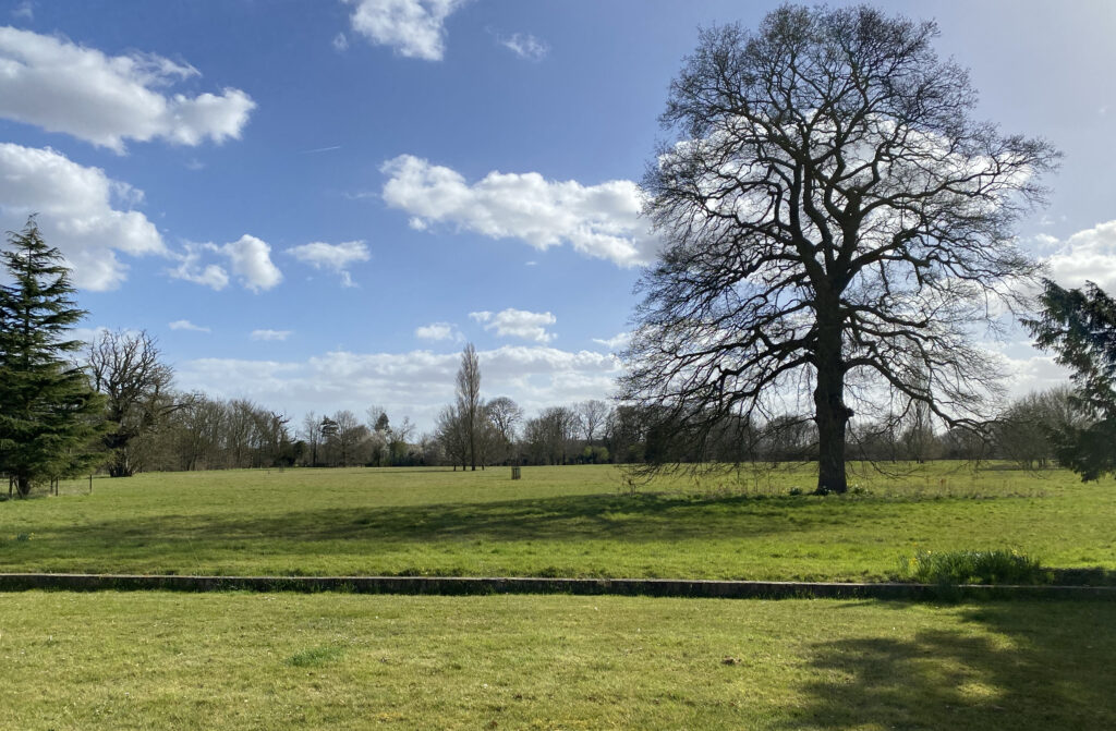
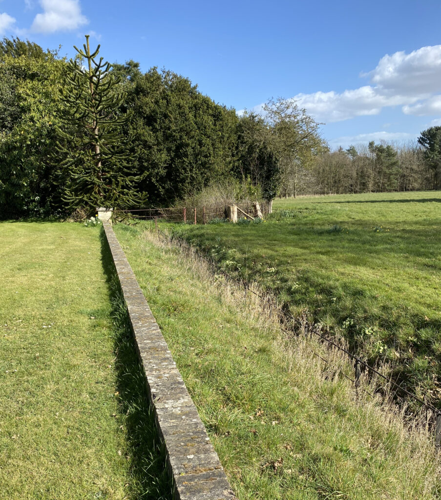
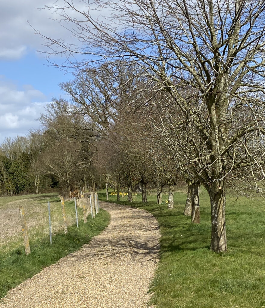
In 1995 the present owners bought the house, a much reduced stable courtyard and the remaining parkland immediately south of the two main drives. The surrounding areas are now in separate ownership and used for arable purposes. The owners have continued the restoration process of the house and the remains of the stable courtyard and planted a number of parkland trees. The two main drives survive in the same positions as in the early-nineteenth century, with trees now lining the south-west drive. A belt of trees and shrubs surrounds the house following the shape of the garden enclosure shown on the 1905 OS map. Within it are the remains of the 1852 stable courtyard, including the north entrance with curved walling on either side and the central, square, highly-ornamented well head. There are lawns to the north and east of the house and the present owners uncovered the line of a ha-ha to the south of the house, probably dating to the end of the eighteenth century or beginning of the nineteenth century when the original house was built, which has been rebuilt.
SOURCES:
Biographical History of Gonville and Caius College, Vol: II, 1801–20.
Birch, Mel, Suffolk’s Ancient Sites Historic Places, 2004.
John Burke, A genealogical and heraldic dictionary of the landed gentry of Great Britain & Ireland, Vol: 2 for 1850.
Burke, John, A genealogical and heraldic history of the Commoners of Great Britain and Ireland, 1835.
Burke’s Peerage, 1885.
Doughty, Henry Montague, Chronicles of Theberton a Suffolk Village, 1910.
Hoppitt, Rosemary, Deer Parks of Suffolk 1086–1602, 2020
The Illustrated London News No. 424, 1850.
Kelly’s Handbook to the Titled, Landed and Official Classes, 1895.
Suffolk County Council, Suffolk Landscape Character Assessment, Rolling Estate Claylands, 2010.
Lingwood, H. R., ‘The Rectors of Martlesham’ in Suffolk Institute of History and Archaeology, Vol: XXV Part 2, 1950.
White, William, History, Gazetteer, and Directory of Suffolk, 1844, 1855.
Winchester College Year Book 1836–1906.
Theberton & Eastbridge website https://thebertoneastbridge-pc.gov.uk/ (accessed March 2025).
The Register (Adelaide, SA: 1901–1929), Tuesday 18 Dec 1928, https://trove.nla.gov.au/newspaper/article/53609649 (accessed July 2021).
Edith’s death registered July to September 1870 in Marylebone, Middlesex. Civil Registration Deaths 1837–2005.
Memorial in Theberton Church.
1872 Sales Particulars, a copy in the present owners possession.
1921 Sales Particulars, a copy in the present owners possession.
Conversation with the present owners in 2025.
Census: 1841, 1851, 1861, 1871, 1881, 1891, 1901, 1911.
1783 Hodskinson’s Map of Suffolk in 1783.
1836 Ordnance Survey map.
1838 (surveyed 1839) tithe map and apportionment.
1883 (surveyed 1882 to 1883) OS map.
1905 (revised 1902) OS map.
1928 (revised 1925) OS map.
1949 (revised 1938) OS map.
1951 (revised 1946 to 1948) OS map.
2023 Google aerial map (Imagery © Bluesky, CNES / Airbus, Getmapping plc, Infoterra Lts & Bluesky, Maxar Technologies, Map data © 2023).
Heritage Assets:
Suffolk Historic Environment Record (SHER): THB 014.
Church of St Peter (Grade I). Historic England No: 1227756.
Theberton Hall (Grade II). Historic England No: 1287529.
Gates, Gateway, Walling and Wall Head 30 metres west of Theberton Hall (Grade II). Historic England No: 1227753.
The Old Rectory (Grade II). Historic England No: 1227758.
Dovehouse Farmhouse (Grade II). Historic England No: 1199213.
Suffolk Record Office (now Suffolk Archives):
SRO (Ipswich) HD 79, Suffolk (Middleton, etc) deeds, manorial records, family and estate papers, with papers of the Betts family, 14th to 19th century.
SRO (Ipswich) HB 108, Acc 1309/19-21, Suffolk (Theberton Hall, etc) deeds and papers, 17th to 19th century.
SRO (Ipswich) HA 75, Doughty family papers, 1701–20th century.
SRO (Ipswich) HB 441/B/37, Deeds of Suffolk Properties, including the Carlton Hall Estate, 1830–54.
Site ownership: Private
Study written: May 2025
Type of Study: Desktop and site visit
Written by: Tina Ranft
Amended:
