(previously Mount House, Prospect House, Brick House)
Parish: THEBERTON
District Council: EAST SUFFOLK (previously Suffolk Coastal)
TM 445 651
Not open to the public
Close to the North Sea coast, Theberton House (Grade II*) is c. 40km (25mls) north-east of Ipswich and c. 2.5km (1.5mls) north of Leiston. The house and parkland is on the eastern side of the B1122 between Yoxford and Leiston and south of Theberton village centre and the Church of St Peter (Grade I), which dates back to the twelfth century. The mainly agricultural parish includes a few scattered farmsteads, compact village and the small hamlet of Eastbridge, a bridging point of the River Minsmere that flows eastward to the sea. A pond just north of the house marks the beginning of a stream that flows northward through osier beds to join the Minsmere. In 1810 an act was passed to enclose the low, common peat wetlands of the Minsmere estuary, although it was not enacted until 1824. Part of the wetlands lay in the parish of Leiston. Theberton House, its walled garden, stable yard and associated buildings form an intimate complex within its small parkland setting.
OWNERS OF THEBERTON HOUSE
Named ‘Mount House’ on Hodskinson’s 1783 map, the house on the site was also known as ‘Prospect House’, which refers to a mount or mound from where there were picturesque views of Leiston Abbey to the south. Henry Montagu Doughty in The Chronicles of Theberton, A Suffolk Village, tells us that at one time the house had belonged to the Jesups, an old Theberton name, but it was a Mr Goldsbury who sold the estate of 81ha (200a) and a number of cottages to Thomas Whiting Wootton (d. 1844) in 1805. At this time the house had changed name again to ‘Brick House’, probably because of its position to an adjacent field called ‘Brick-kiln Piece’.
After extending the house c. 1834, Thomas renamed it ‘Theberton House’ and the following year it was inherited by his step-son, Thomas Gibson (1806–84), whose father was Major Thomas Gibson. Major Thomas is said to have made his fortune from his West Indies sugar plantations. He returned to England with his wife, Isabella, and son but died in 1807, a year after the birth of their son, leaving Isabella a widow. In 1810 Isabella married Thomas Whiting Wootton.
After inheriting Theberton House it became Thomas’s (born 1806) country residence, but he spent much of his time in London. In 1832 Thomas married Susanna Arethusa (later known just as Arethusa), the wealthy daughter of Sir Gery Cullum of Hardwick House near Bury St Edmunds. With reforming views, Arethusa entertained significant artistic, political and diplomatic figures in their London home, including Thackeray, Richard Cobden, Victor Hugo and Disraeli. She was also a friend of Charles Dickens.
In 1839 Thomas Gibson took the additional name of Milner, which is said to have been in honour of a Robert Milner of Ipswich, to become Thomas Milner-Gibson. Thomas had entered politics as the Tory MP for Ipswich, but like his wife he soon became a radical reformer. He defected to the Liberal Party and entered Lord Palmerston’s cabinet in 1859 and was known as a witty public orator. During this period the family invested in land in Islington, London, to build housing, which still exists today as the desirable Georgian terraces of Theberton Street, Milner Square and Gibson Square.
Although spending much time apart over the following years – Thomas on his yacht and Arethusa in Paris – they produced seven children, plus at least one illegitimate child from an affair between Thomas and a servant, Susan Bowles. This child was named Thomas Gibson Bowles and he was supported by the family throughout his childhood and went on to become a leading journalist, founding Vanity Fair and The Lady. After losing his seat in 1868, Thomas Milner-Gibson was mainly to be found on his yacht and died in Algiers in 1884, being brought back to Theberton to be buried. Arethusa spent most of her later life in Paris where she continued to entertain and bring together artists and radical thinkers. After her death, a year after her husband, she was buried in the Cullum family vault near Bury St Edmunds.
When Thomas Milner-Gibson died Theberton House and their London home were inherited by Jasper Joseph Alexander Milner-Gibson (1852–98), one of their two surviving sons. The other son, George Gery, but known as Gery (1857–1921), was left little as he was to inherit his mother’s family seat of Hardwick House near Bury St Edmunds, becoming George Gery Milner-Gibson-Cullum, a well-known antiquarian and author and the last Cullum baronet. Jasper spent little time at Theberton, renting the house to various people including Vancy Harper Creese and his family in 1881 who was recorded as the eldest son of a Baronet, and ten years later Lord Knutford.
Jasper died in 1898 and the estate was left to his step-son William Archer Milner-Gibson (1879–1961), a military man. During William’s ownership wider family members made the house their home, such as his mother and her third husband, Antonio Lavy-Charré who were occupants of Theberton House in 1916. By 1925 William had returned to Theberton and after divorcing his first wife. A year later he married the American Mary Forvé. In 1927 the estate was sold and had a number of owners until the present family bought it in the 1960s.
THEBERTON HOUSE
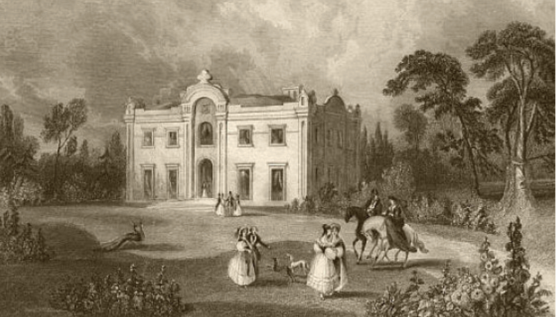
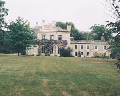
The house that Thomas Whiting Wootton bought is said to have been quite small and named ‘Brick House’. With its eighteenth-century core, the house was extensively re-modelled between 1830 and 1834 by Thomas and re-named ‘Theberton House’. The remodelling included building a new rectangular house south-west of the original house, which became the service wing. A second smaller wing was attached to the new main house. Writing in 1972, the architectural historian Richard Fawsett described it as ‘an example of a curious eclectic picturesque phase of neo-Classicism that came to the fore at the turn of the eighteenth and nineteenth centuries’ and that it was ‘clearly the work of a provincial architect’ suggesting an ‘East Anglian builder from a centre such as Ipswich’.
It is not known who the architect was although Sir Howard Colvin, another architectural historian, suggested that the similarities between The Grove in Little Bealings, near Ipswich and Theberton House suggest it may have been the work of Perry Nursey, the architect, landscape designer and advocate of the picturesque style. Through his marriage to Ann Simpson, Perry owned the Little Bealings Estate and is believed to have been the architect of their home, The Grove. Perry probably also knew Thomas Wootton socially because in 1829 Thomas had been a subscriber to the Revd Perry Nursey’s ‘Evening, with other poems’, who was Perry Nursey’s son.
The entrance front faces south-west and looks out over parkland, as do the south-east and north-west elevations, the latter with paths to the pleasure grounds and walled garden (Grade II). A rear courtyard was created between the service wing and the smaller secondary wing that gave access to the gardens to the west via a gateway with a date plaque of ‘1830’.
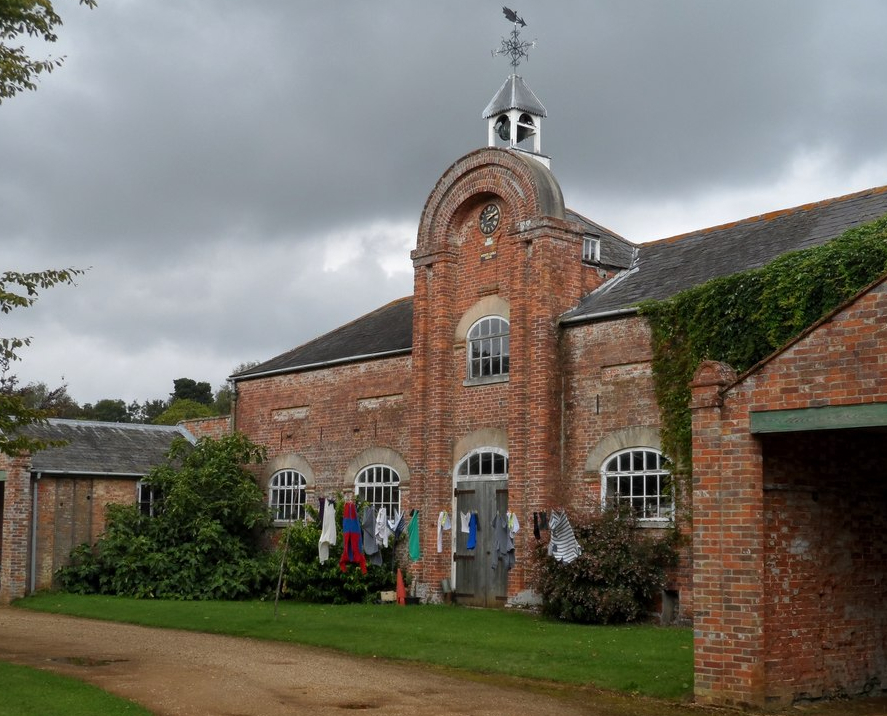
A further gateway (Grade II) of stone piers surmounted by spheres gives access to the stable block (Grade II). This has a tall central two-storey block in a style similar to that used on the house, with the date ‘1836’ on a plaque below the clock face. Two single-storey projecting wings to the left and right appear to have been added in 1841.
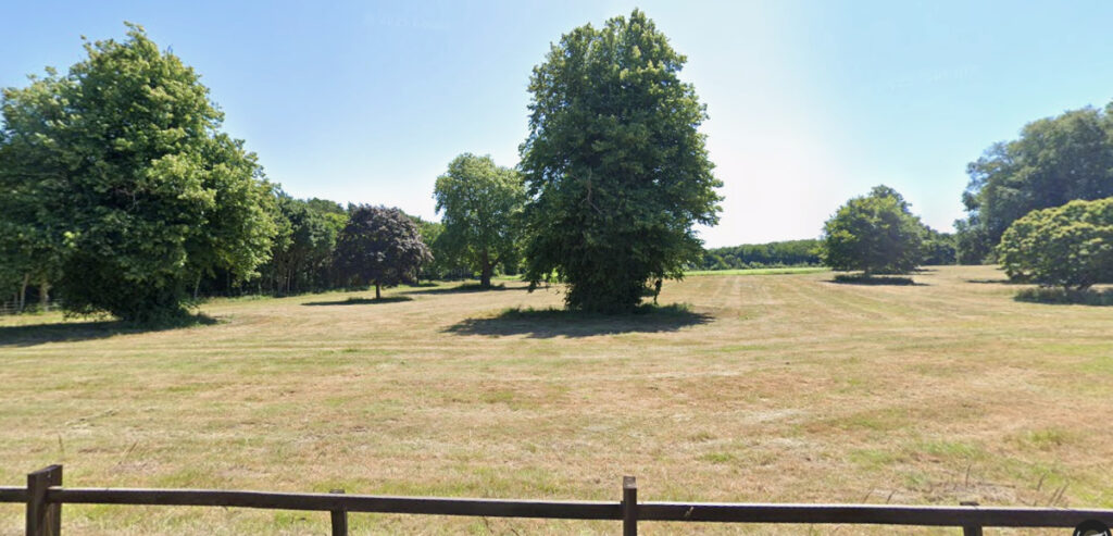
THE PARKLAND
Although the house is named on Hodskinson’s 1783 map, which is usually an indicator of a house of some status, it is thought to have been fairly small and probably with no parkland at this time. The name ‘Mount House’ refers to a viewing mount, or mound, located on the southern tip of a field south-east of the house. This probably had a summerhouse on top and would have given excellent views of Leiston Abbey to the south-west.
It is believed that a park for Theberton House was created during the 1830s after much of Theberton parish had been enclosed in 1824. In the 1830s the small landscape park and gardens extended to c. 20ha (50a).
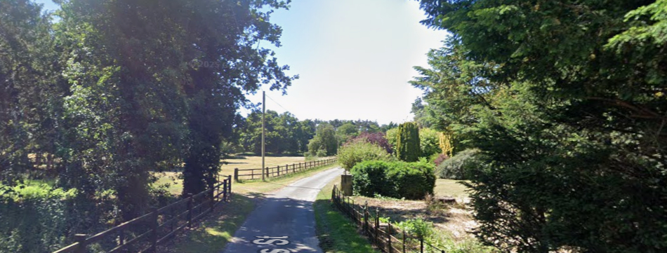
The tithe map drawn in 1839 shows the parkland bounded to the west by the road between Yoxford and Leiston with clumps of trees at intervals along the boundary, giving glimpses of the house from the road. The northern boundary of the park was a narrow oblong arable field, although the northern entrance was further north at the junction of Onner’s Lane and today’s B1122 where a wrought iron six-bar gate and piers (Grade II) survived in 2010, although hardly visible amongst overgrown undergrowth in a tree belt. From here a drive passed through belts of trees, known as ‘Brown’s Plantation’ and ‘Fishpond Groove’, and continued through the parkland to arrive at a further surviving gate (Grade II) at the junction of the parkland and pleasure gardens and onward to the entrance front of the house. The drive then continued southward.
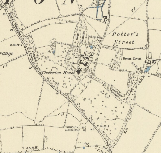
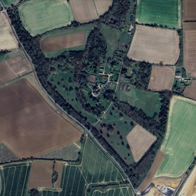
A separate field south of Theberton House was probably incorporated into the parkland when the new house was built. However, this field was separated from the northern parkland by a lane, today’s Potter’s Street, that ran from the Yoxford to Leiston road northward through the hamlet of Potter’s Street and onward towards Eastbridge. When the tithe map was produced this lane appears to have been blocked-off where it crossed the parkland, becoming a drive for the house. Even in 1884 this situation persisted, but by 1905 that section of drive had been officially converted giving public right of way so that Potter’s Street continued to the junction with the road between Yoxford and Leiston.
After crossing the old lane the southern drive swept through further parkland to a south entrance flanked by trees near the corner of the L-shaped plantation, later named ‘Greenhouse Plantation’, that forms a section of the parish boundary with Leiston. The entrance was close to the remains of the mount. This drive across the southern parkland is shown on the tithe map of 1838 but does not appear on the 1884 OS map, although later OS maps still depict it. This may suggest a cartographic omission. It was not until the second half the twentieth century that it finally disappeared, as had the northern drive.
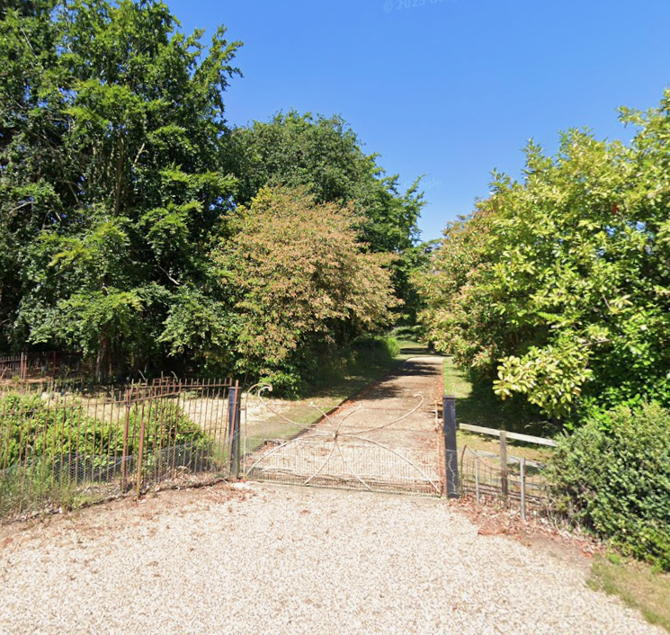

Today’s main entrance to the house has a mid-nineteenth century wrought iron 6-bar gate with sweeping curves and central rosette motif gateway (Grade II). It marks the point where the old southern drive crossed Potter’s Street. Further north along Potter’s Street is an unlisted gateway with two wrought iron gates of a similar design that gives access to the rear of the house and stable block.
THE PLEASURE GARDENS

Writing in 1844 William White described Theberton House as having ‘… a beautiful lawn [lawn is another name historically used for parkland], pleasure grounds and gardens…’ with the house as ‘A commodious stuccoed mansion.
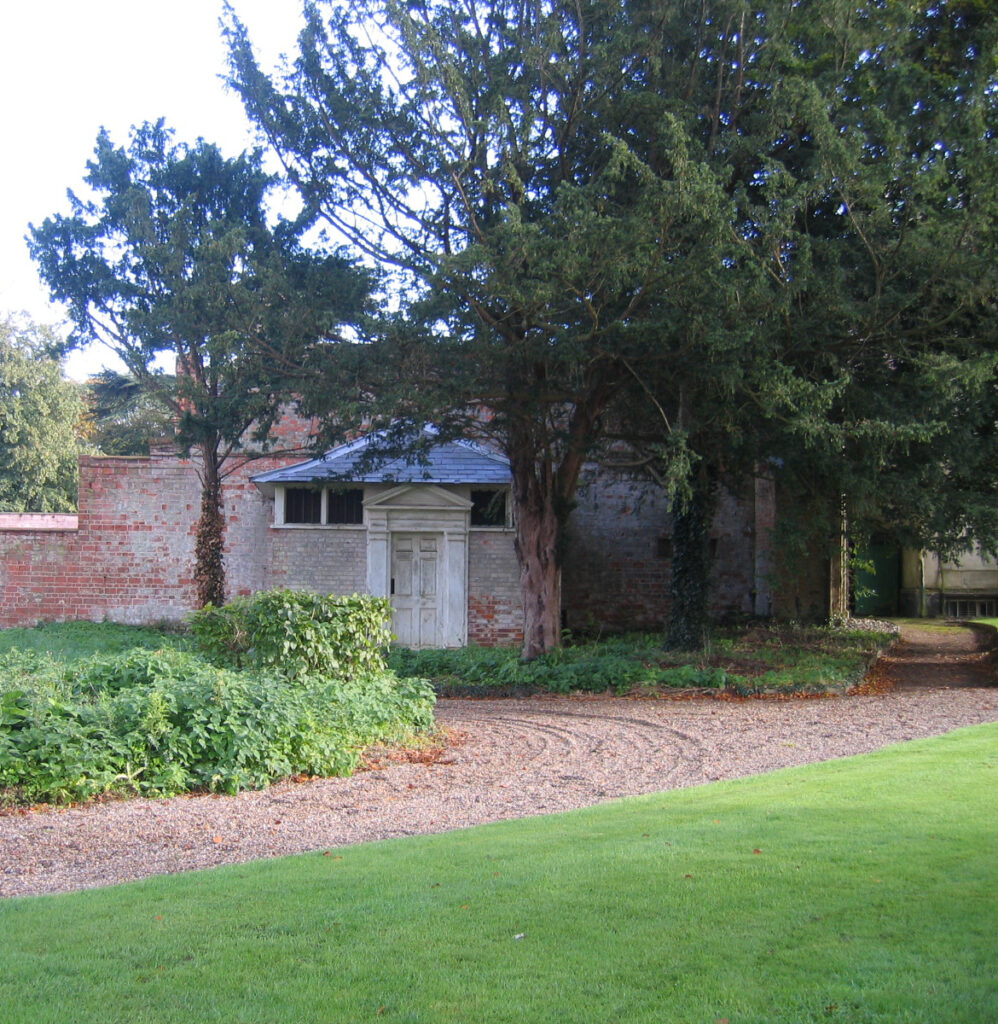
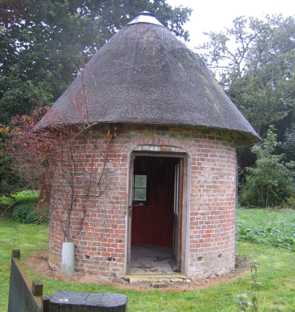
Today the pleasure gardens cover c. 4.5ha (11a), having reduced slightly since the nineteenth century. Attached to the rear of the secondary wing there is a game larder designed with pedimented doorway reminiscent of the house detailing and thought to have been built at a similar time. From here paths lead into the pleasure gardens mainly to the north of the house and give access to and around the walled garden via a number of gravel paths that date back to the nineteenth century. Other paths have been grassed-over, although they lie just below the surface. One path leads from the house north-westward and west of the walled garden to encircle a charming round thatched apple store that is shown on the 1884 OS map.
WALLED GARDEN
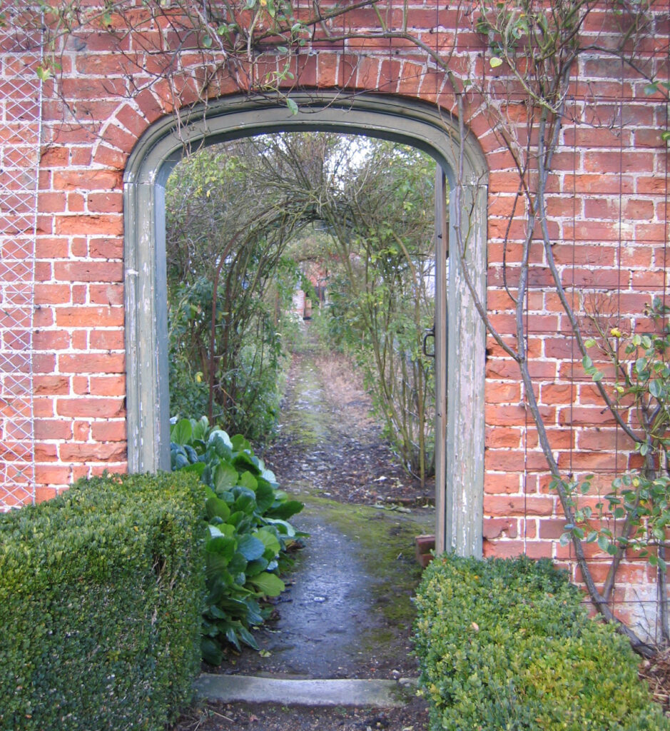
A listed rectangular walled garden is accessed through the pleasure gardens c. 60m (196ft) north of the house. It had been built by the time of the tithe map of 1839 and is probably contemporary with the house. It encloses an area of c. 40m x 30m (131ft x 98ft). There are moulded copings on the top of the red brick walls and it is entered through two elliptical arched gateways. One is the main southern entrance, the other through the east wall giving access to another low walled enclosure.
To the north end there is a lean-to glasshouse with curved barrel-shaped roof of small panes in cast iron frame that is also included in the listing. Outside, against the south wall, there is a lean-to vinery shown on the 1884 OS map, the map also showing the existing internal path layout with perimeter and cross paths. In 2010 there was a modern plastic glasshouse on top of earlier brick foundations standing beside the glasshouse with the barrel-shaped roof. The whole garden is still productive.
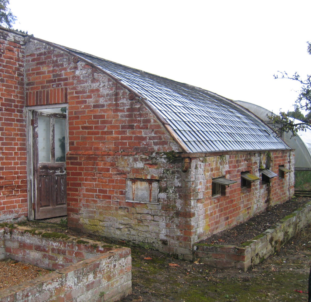
Beyond the walled garden there is a low-walled enclosure and a number of small buildings that are believed to have been a bothy and part of a small farm complex. These are thought to pre-date the 1830s house and likely relate to the original ‘Mount House’ or ‘Brick House’. In 2010 this area was dotted with fruit trees.
SOURCES:
Boase, George Clement, Dictionary of National Biography, 1885–1900, Vol. 21. https://en.wikisource.org/wiki/Dictionary_of_National_Biography,_1885-1900/Gibson,_Thomas_Milner- (accessed December 2025).
Death Registration of Thomas Whiting Wootton in Bything April, May, June, 1844.
Doughty, Henry Montagu, The Chronicles of Theberton, A Suffolk Village, 1910.
Dugdale, Thomas, Curiosities of Great Britain. England & Wales Delineated. Historical, Entertaining & Commercial, 1860.
Fawsett, Richard, ‘An Architectural History of Theberton House, Suffolk’, 1972.
Guinness, Jonathan, The House of Mitford, 1984.
Howard, Joseph, Jackson and Crisp, Frederick, Arthur (eds), Visitation of England and Wales Notes Vol. 1, 1896.
Parish Records for Dedham St Mary the Virgin, 13th July 1810.
Suffolk County Council, Suffolk Landscape Character Assessment, Rolling Estate Claylands, 2010.
Suffolk Gardens Trust Walled Kitchens Gardens Recording Group Survey, 2010.
White, William, History, Gazetteer and Directory of Suffolk, 1844.
Williamson, Tom, Suffolk’s Gardens and Parks, 2000.
Griffmonster-walks.blogspot.com/2011/01/eastbridge-circular-walk-abbey-and.html (accessed March 2025).
walkhttps//en.wikipedia.org/wiki/Hardwick_House,_Suffolk (accessed January 2020).
https://milnergibson.wordpress.com/2013/08/03/the-milner-gibsons/ (accessed December 2025).
https://londontraveller.org/2014/06/20/bradshaws-hand-book-to-london-the-milner-gibson-estate/ (accessed October 2019).
www.anthonyadolph.co.uk (accessed January 2020).
Theberton & Eastbridge website https://thebertoneastbridge-pc.gov.uk/ (accessed March 2025).
London Gardens Online, www.londongardensonline.org.uk/gardens-online-record. Php?ID=ISL032 (accessed January 2020).
Census: 1841, 1851, 1861, 1871, 1881, 1891, 1901, 1911.
Maps:
1783 Hodskinson’s Map of Suffolk in 1783.
1836 Ordnance Survey map.
1838 (surveyed 1839) tithe map and apportionment.
1883 (surveyed 1882 to 1883) OS map.
1905 (revised 1902) OS map.
1928 (revised 1925) OS map.
1949 (revised 1938) OS map.
1951 (revised 1946 to 1948) OS map.
2023 Google aerial map (Imagery © Bluesky, CNES / Airbus, Getmapping plc, Infoterra Lts & Bluesky, Maxar Technologies, Map data © 2023).
Heritage Assets:
Suffolk Historic Environment Record (SHER): THB 004.
Theberton House (Grade II*). Historic England No: 1228378.
Church of St Peter (Grade I). Historic England No: 1227756.
Walls Enclosing Garden 60 metres to north of Theberton House and Greenhouse at north end (Grade II). Historic England No: 1287235.
Theberton House Stables. (Grade II). Historic England No: 1228268.
Gateway 45 metres north of main entrance to Theberton House (Grade II). Historic England No: 1228269.
Gate and Gate Piers 105 metres south-west of main entrance to Theberton House (Grade II). Historic England No: 1287237.
Gate and Gate Piers at junction of Leiston Road and Onner’s Lane (Grade II). Historic England No: 1287303.
Gate and Gate Piers 80 metres north-west of main entrance to Theberton House (Grade II). Historic England No: 1287260.
Suffolk Archives (previously Suffolk Record Office):
(SA) K681/1/447/31 and 32. Photographs of Theberton House fete, late-nineteenth century.
(SA) K681/1/447/21. Photograph of large group in grounds of Theberton House, c. 1880.
(SA) HD4052/40/13. Engraving of Theberton House, October 1930.
Study written: December 2025
Type of Study: Desktop and site visit 2010
Written by: Tina Ranft
Amended:
