Parish: TOSTOCK
District Council: MID SUFFOLK
TL 951 638
Not open to the public
On the edge of the Suffolk clayland plateau, the former rectory of Tostock (Grade II) is west of the main village settlement of Tostock, which is c. 11km (7mls) east of Bury St Edmunds. The parish Church of St Andrews (Grade I) lies to the east of the village.
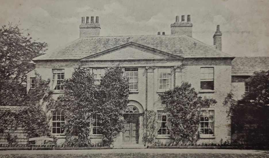
The Revd Maurice Moseley, whose family owned much of the land in and around Tostock at the time, had been rector of Tostock in the late-eighteenth century. In 1796 he was followed by the Revd James Oakes, the second son of the Bury St Edmunds banker and diarist, James Oakes. James bought the living of Tostock for his son on his marriage to Elizabeth Tyrell, the daughter of the Revd James Tyrell, and is believed to be responsible for building the rectory on the present site c. 1800. It was extended to the right side and rear slightly later. To either side of the present house front are semi-elliptical screen walls about 2.5m high, built of gault brick – possibly from nearby Woolpit – to match the house. In each wall there is an archway with wrought iron fencing within the lower part, which once opened into the gardens on either side.
Further land was acquired until the Revd James became one of the larger landowners in the parish. In 1844 Tostock Rectory was described in White’s Directory as a good residence with fifteen acres of glebe. It is shown on the tithe map of 1843 with parkland – described on the apportionment as ‘lawn’ – to the south, west and north of the house, most bounded by established shelterbelts of trees. The entrance into the site was, as it remains, from the east and flanked by clumps of trees, although few of these trees survive today. A building, now a private residence but originally a sixteenth century farmhouse that became known as the Old Rectory Lodge (Grade II) sits within the northern clump. With trees lining the drive to the north hiding stable yard buildings, there were views across the parkland to the south as it approached a turning circle south of the entrance front of the house. There appears to have been little in the way of formal gardens around the house, just an area of lawn defined by an irregular enclosure, giving way to parkland beyond. The stable yard giving access into a square walled garden lies immediately to the east of the house. The walled garden has a pronounced curved corner where it attached to the rear of the buildings of the yard. In 1843 the garden had a simple layout of perimeter and cross-paths with a gate in the north wall leading, in a dog-leg, to a path flanked by an avenue of trees stretching northward into the parkland, although the avenue had gone by 1905, leaving just a belt of trees to the east side. However the path remained.
James Oakes died in 1861 aged sixty-one, although his wife and children stayed on at the rectory for at least the next ten years while the new rector, William Gilbert Tuck, lived at Tostock House until his death in 1887. At the time of the census in 1881 the Revd Andrew Foster-Melliar was living at the rectory with his family and is recorded as a curate. He must have had an interest in gardening and horticulture as his name features in the Journal of Horticulture, Cottage Gardener and Home Farmer for 1881 and the Gardeners Chronicle and New Horticulturalist in 1885.
The Revd Julian G. Tuck, son of the Revd William Tuck, became rector after his father’s death and moved into Tostock Rectory. Julian was a renowned botanist, naturalist and was also interested in gardening. He was documented in the Proceedings of the Linnean Society of London of 1895 as having planned and planted a rose garden at his home. Julian was still at the rectory in 1932.
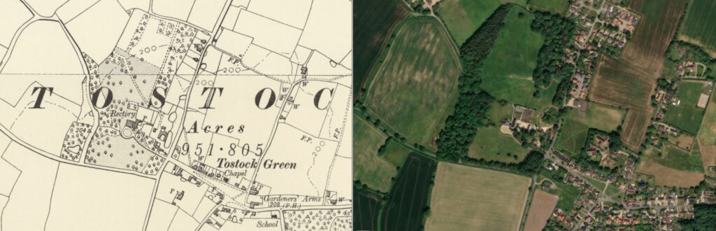
By the 1950s the rectory had become the home of a farmer, as it remained well into the twenty-first century. For sale in 2022, the house had ceased to be a farmhouse and now had c. 13ha (33a) of parkland with the old lodge and barn behind appearing to be it in separate ownership. The curving entrance drive and layout of the grounds has changed little since the mid-nineteenth century with shelterbelts surrounding much of the parkland, although now much denser, but with fewer freestanding trees. The main focus of ornamental planting is within the surviving walled garden, the 2022 sales particulars describing it as ‘overflowing with roses’, perhaps the site of the rose garden originally planned and planted by the Revd Julian Tuck. However a quarter is now taken up by a swimming pool screened by hedging.
SOURCES:
A Concise Description of Bury St. Edmund’s: And Its Environs, Within the Distance of Ten Miles, 1827.
Birch, Mel, Suffolk’s Ancient Sites Historic Places, 2004.
Copinger, W. A., The Manors of Suffolk, Vol. 6, 1910.
Fiske, Jane, ed., The Oakes Diaries, Suffolk Records Society, Vol. XXXIII.
Garden Life, Vol. 17, 1910.
Gardeners Chronicle and New Horticulturalist, 1885.
Journal of Horticulture, Cottage Gardener and Home Farmer, 1881.
Mid Suffolk District Council, Tostock Conservation Area Appraisal, 2006.
Proceedings of the Linnean Society of London, 1895.
Suffolk Institute of History & Archaeology Proceedings VoI. XXXVIII, Part 3, 1995.
The Gentleman’s Magazine and Historical Chronicle, 1861.
The Spectator, Vol. 198, 1957, letter from D.E. Lilley concerning British farming and Europe.
The Zoologist; A Monthly Journal of Natural History, 1908, 1916.
Ticehurst, Claud, B., A History of the Birds of Suffolk, 1932.
White, William, Directory of Suffolk, 1844.
https://tostock-pc.gov.uk/past-and-present/digital-archive/chapter-2-farming-in-tostock/ (accessed June 2025)
https://tostock-pc.gov.uk/past-and-present/digital-archive/chapter-1-st-andrews-church/ (accessed June 2025)
Census: 1851, 1861, 1871, 1881, 1901, 1911.
1843 (surveyed 1843) tithe map and apportionment.
1884 (surveyed 1883) Ordnance Survey map.
1905 (revised 1903) OS map.
1953 (revised 1950) OS map.
Heritage Assets:
Suffolk HER: TCK 003, 039.
The Old Rectory, Norton Road, Tostock (Grade II), Historic England No. 1032399.
Old Rectory Lodge, Norton Road, Tostock (Grade II), Historic England No. 1284181.
Church of St Andrew (Grade I), Historic England: No. 1352395.
Suffolk Record Office (now Suffolk Archives):
SRO (Bury St Edmunds) FL642/4/8, The Revd Maurice Moseley, rector of Tostock…, 21 October 1783.
SRO (Bury St Edmunds) Acc 2753/26, 39, Misc Suffolk (Tostock, etc) deeds and papers, 18th century–1890.
SRO (Bury St Edmunds) 1754/1/467, Brent Eleigh Estate Records, Deeds and Related Papers, 1906.
SRO (Ipswich) K681/1/461/4, The Old Rectory Tostock, 1960–70.
Site ownership: Private
Study written: July 2025.
Type of Study: Desktop
Written by: Tina Ranft
Amended:
