(formerley Uggeshall Rectory)
Parish: UGGESHALL
District Council: EAST SUFFOLK (previously Waveney)
TM 455 803
Not open to the public
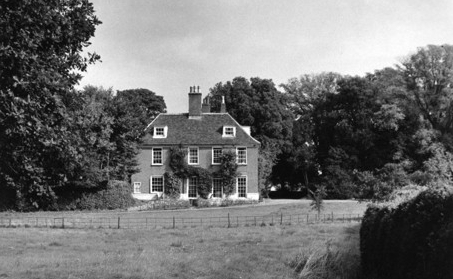
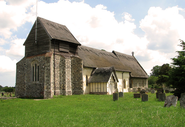
Uggeshall House (Grade II) is a former rectory standing south of the thatched, medieval Church of St Mary (Grade I) in the rural parish of Uggeshall. Close to the main A12 road between Ipswich and Lowestoft c. 9.5km (6mls) north-east of Halesworth, it lies in a flat landscape on the edge of the Suffolk clayland plateau. The house has an early-eighteenth century core, possibly dating to 1720 when John Edwards BA was presented to the Rectories of Uggeshall and Sotherton, with later additions to the rear.
The Revd Thomas Sheriffe became Rector of Uggeshall with Sotherton in 1799. He was a senior member of a local family who became wealthy in north-east Suffolk in the seventeenth century. He made a good marriage with the Affleck family, baronets of Dalham in West Suffolk, dealt in real estate and, like a banker, gave loans to local people. He was associated with the development of Southwold as a seaside resort, including financing the building of some houses that survive today. Much of his time was spent as a resident in Southwold, whilst he still kept his base in Uggeshall, where the 1841 census lists him living with his family and seven servants.
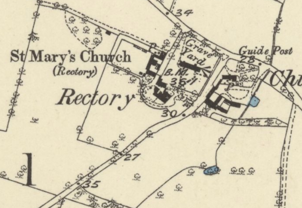
The 1838 tithe map shows the main entrance façade facing east, southern garden front overlooking parkland with later house additions forming an irregular courtyard to the west. What appears to be an enclosed walkway joined the house to a barn attached to the south-west corner of the churchyard that would have given access to the path leading to the south porch of the church. Although not entirely clear on the tithe map, there appears to be a lean-to glasshouse/conservatory attached to the south elevation of the house. To the west were pleasure gardens with a path to a summerhouse with views over parkland and on through a shelterbelt of trees that enclosed the parkland area to the south and west. The east drive was lined with trees and curved to the front of the house. Rear access was gained from a track from the north that passed a courtyard of stables/coach house, stores and offices. This was attached to the east wall of a walled garden with a structure, probably a lean-to glasshouse, facing south and attached to the north wall. This garden is likely to be contemporary with the main wing of the house, although it is possible it was one of the improvements made by Thomas Sheriffe in the first forty years of the 1800s.
After fifty-six years as rector, Thomas died in 1842 and his family moved to Southwold, with the house described in 1848 as a ‘commodious parsonage-house, much improved by the late rector, The Rev. Thomas Sheriffe’… ‘the glebe comprises 43 acres [17.4ha]’, which would have given a good income.
The Revd William Charles Edgell took over from the Revd Thomas Sheriffe, dying in 1886 when the Revd Arthur Ashton became rector. Arthur stayed at Uggeshall for fifty years until his death in 1938, writing his memories in Fifty Years Work in A Suffolk Parish, published in 1936. He spent much of his time tending his flower beds and c. 1908 found an unusual primrose growing in the garden. This prolific plant became known as ‘Helio’, due to its colour being something between heliotrope and pink, was granted an award from the Royal Horticultural Society and sold at Covent Garden and Manchester markets. By the 1930s he had 40,000 plants growing in the walled garden. Arthur went on to cultivate two further primrose varieties, ‘Albion’ and ‘Chrome Queen’, although no known plants survive today.
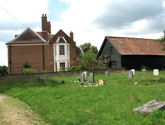
Today Uggeshall House is the base for a farming estate with the access drives from the east and rear remaining as they were in 1838 and probably dating back to the building of the main range of the house in the early-eighteenth century. The courtyard buildings attached to the east wall of the surviving walled garden have been converted to residential and holiday lets and a pleasure garden created within the walled garden. The house still has a small parkland area to the south and west and there is a length of mid-nineteenth century low boundary wall (Grade II) that extends from the south-east corner of the churchyard westward to the path accessing the rear of the house.

SOURCES:
Ashton, Revd Arthur, Fifty Years Work in A Suffolk Parish, 1936.
Downing, Ruth and Bellamy, Denis, Notes on the Sheriffe Family of Uggeshall, Southwold and Henstead, 2006.
Lewis, Samuel, A Topographical Dictionary of England, Vol. IV, 1848.
Scriven, Paul, ‘The Primrose Parson’ in Suffolk Garden Trust Newsletter, Autumn 2008.
White, William, History, Gazetteer, and Directory of Suffolk, 1844 and 1855.
Census: 1851, 1861, 1871, 1891, 1901, 1911.
1838 (surveyed 1838) tithe map and apportionment.
1883 (surveyed 1882 to 1883) Ordnance Survey map.
1905 (revised 1903) OS map.
1928 (revised 1925) OS map.
1951 (revised 1946 to 1947) OS map.
2022 Google aerial map (Imagery © Bluesky, CNES / Airbus, Getmapping plc, Infoterra Lts & Bluesky, Maxar Technologies, Map data © 2022).
Suffolk Record Office:
Suffolk Record Office (Ipswich) HB26/412/816. Abstract of the title of Rev. Thomas Sheriffe, 1744–1793.
SRO (Ipswich) HB26/412/815. Abstract of the title of Rev. Thomas Sheriffe, c. 1799.
SRO (Ipswich) HA11/C9/41. Plan of part of the glebe lands belonging to the rectory of Uggeshall, 1841.
Norfolk Record Office: WLS/XXXV111/31/419x.8. Letters of ordination as priest by the Bishop of Norwich of John Edwards, B.A. and documents regarding his presentation to the Rectories of Uggeshall and Sotherton.
Heritage Assets:
Uggeshall House (Grade II), Historic England No. 1284131.
Church of St Mary (Grade I), Historic England No. 1284129.
Churchyard Walling 35 metres south of Church of St Mary (Grade II), Historic England No. 1032104.
Site ownership: Private
Study written: February 2023.
Type of Study: Desktop
Written by: Tina Ranft
Amended: May 2025
