(also known as Wherstead Lodge)
Parish: WHERSTEAD
District Council: BABERGH
TM 157 407
Not open to the general public except for business users
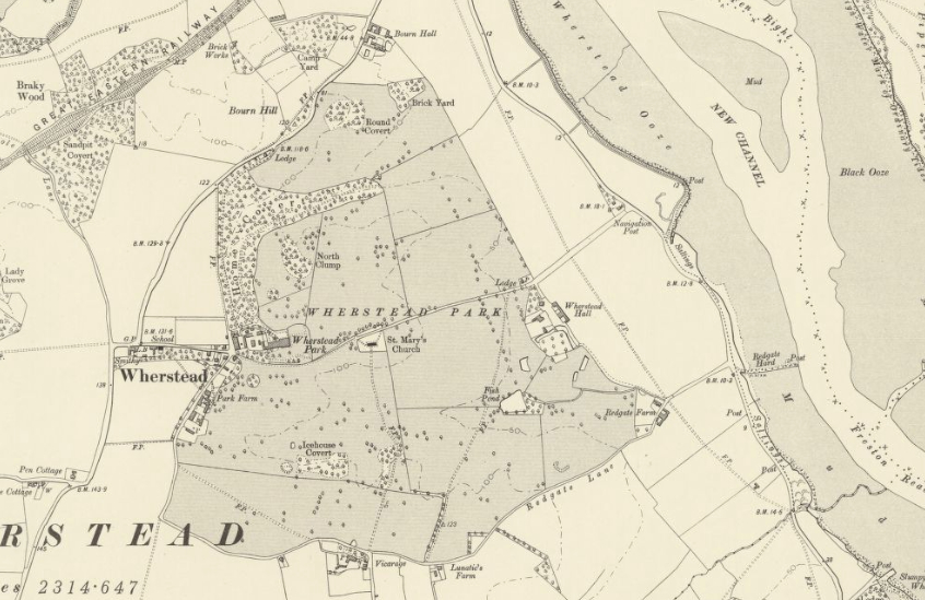
Once within a landscape park, eighteenth century Wherstead Park (Grade II) is c. 2.5km (1.5mls) south of Ipswich and lies on the Shotley peninsular, a plateau of fertile loamy soils. The ancient manor of Wherstead included estate lands on the plateau and river valleys that steeply descend north-eastward to the River Orwell, in Old English Wherstead means ‘place by a wharf or landing place’. Wherstead Park should not be confused with fifteenth century Wherstead Hall (Grade II), which lies to the east and is on the site of the original manorial complex. Its status sharply declined in the late Middle Ages, becoming a farmhouse and part of the Wherstead Park landholdings by the early-nineteenth century. Today Wherstead Hall is within the Suffolk Food Hall complex.
Due to the nature of the soils, arable farming has always been a major feature in the relatively sparsely populated parish where most of the houses cluster around or near the site of the present Wherstead Park mansion. The Church of St Mary (Grade II*) lies isolated a short distance away to the east beside a track leading down the slope towards the Suffolk Food Hall site and onward to the River Orwell. There are deposits of clay on nearby Bourne Hill, where bricks for the Wherstead Park Estate were produced until the brickworks closed in 1861.
OWNERS OF THE WHERSTEAD ESTATE
The first Sir Robert Harland (c. 1715–1784), who was made Lord of the Admiralty in 1782, owned a number of estates in Suffolk including nearby Sproughton where he made his home. He extended his landholdings with the purchase of the Belstead Estate from the Blois family and the estates and manors in Wherstead from Thomas Wenham Coke, Esq. His only son, Sir Robert Harland Bt. (1765–1848), inherited the Wherstead manor and estate on his father’s death in 1784.
Sir Robert had big plans for Wherstead and substantially extended the existing house on the estate and commissioned designs for a landscape park. In 1813, Sir Robert exchanged the Wherstead Estate with his brother-in-law John Vernon (1776–1818) for Orwell Park. John was a member of the rich landowning Vernon family who held estates throughout Suffolk during the eighteenth century. It is unclear who was the instigator of this move, although writing in 1887 the then vicar of Wherstead and chaplain to Queen Victoria, Foster Barham Zincke, suggested that John Vernon wished to be near his great friend George Capper who was the vicar of Wherstead in 1813.
With the death of John in 1818, the Wherstead estate returned to the Harlands when Lady Arethusa Harland (c. 1780–1860), wife of Sir Robert, inherited the Vernon estates. However, Sir Robert and his wife did not return to live at Wherstead Park, choosing to keep Orwell Park as their main Suffolk residence. As a result, over the next three decades there followed a succession of tenants, all with a keen interest in hunting and shooting such as Lord Granville. During a ten year period between 1826 and 1835 Wherstead Park was home to the parents of the poet Edward Fitzgerald, until the family moved to Boulge near Woodbridge.
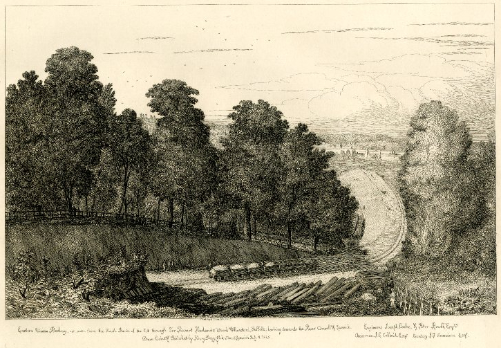
There followed the sportsman and author William Scroope who wrote The Art of Deerstalking and Days and Nights of Salmon-fishing in the Tweed, published in 1843. However, William felt driven from Wherstead with the coming of the railway in 1846 when the route of the Colchester to Ipswich line skirted Home Covert in the north of the park, bringing with it the inevitable influx of railway construction workers, noise and pollution to this previously rural area.
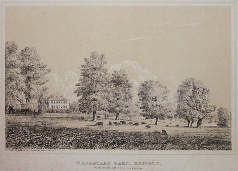
Having sold Orwell Park to the politician and a keen amateur astronomer George Tomline (1813–1889), in 1847 Sir Robert returned to Wherstead. But within a year Sir Robert died, leaving his wife Lady Harland living in the house until her death in 1860. Initially the estate was inherited by a distance relative, the Revd Charles Jenkins, who changed his name to Vernon, but three years later he died and the estate passed to Arethusa’s great nephew, Charles Edmund Dashwood. Recorded as covering c. 916ha (2,264a) in 1887, the Dashwood family owned Wherstead Park Estate into the twentieth century. The house and park were described in Kelly’s Directory of 1900 as a mansion ‘… of white brick, pleasantly situated on an eminence, with commanding prospects of the river Orwell and the surrounding country’.
As on many Suffolk estates, World War I saw the mansion used as a convalescent hospital for injured soldiers and the park became a staging depot for horses in transit to the frontline on the continent. It was once again commandeered in World War II and used as a military camp, with much of the park ploughed up to grow food. After the war, Eastern Electricity bought the estate and used the mansion, garden and park as its headquarters and by 1951 the Paul family owned much of the estate’s agricultural land, which is believed to still be farmed by the same family today.
Massive disruption was to follow in 1982 with the opening of the Orwell Bridge, resulting in the A14 trunk road running only a few hundred metres north of the mansion itself, slicing through its surrounding pleasure grounds and completely cutting off Home Covert from the parkland. In the twentieth century a modern office complex was built attached to the old mansion. In 2008 the Wherstead Park grounds had reduced to c. 7ha (17.5a) and were bought by the East of England Co-operative Society to use as its headquarters, an events venue and additional office space that was rented out. In the same year an application was put forward to extend the area of the office complex by the further development of the c. 3.3ha (8a) walled garden to the west of the mansion that was owned by the Paul family. As of 2025 this development had not taken place and the walled garden lies uncultivated, occasionally used to graze cattle and believed to still be owned by the Paul family. In 2025 the East of England Co-operative Society put the site up for sale.
THE MANSION
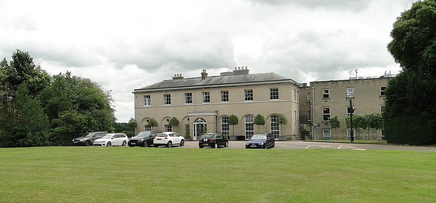
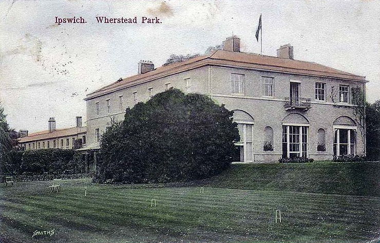
After inheriting the Wherstead Estate in 1784 Sir Robert Harland Bt. commissioned Jeffry Wyatville (1766–1840), the architect and garden designer best known for his projects at Chatsworth and Windsor Castle, to substantially extend an existing house to form a much grander residence. A foundation stone bearing the inscription ‘The first stone of this house laid by Sir Robert Harland Bt. July 29th 1792’ survives to the left of the entrance on the seven bay north elevation. Built of grey brick with ashlar dressings, the elegant two storey house was constructed with hipped roofs and shallow dome and cupola above an impressive central staircase. The service wing was to the west and the mansion’s east-facing elevation had fine views of the River Orwell. An entrance porch was added later.
Wherstead Park mansion, often referred to as Wherstead Lodge during the nineteenth century, was much extended during the twentieth century, with the addition of modern office spaces attached to the original service wing. However, Jeffry Wyatville’s original mansion remains largely as it was when first built.
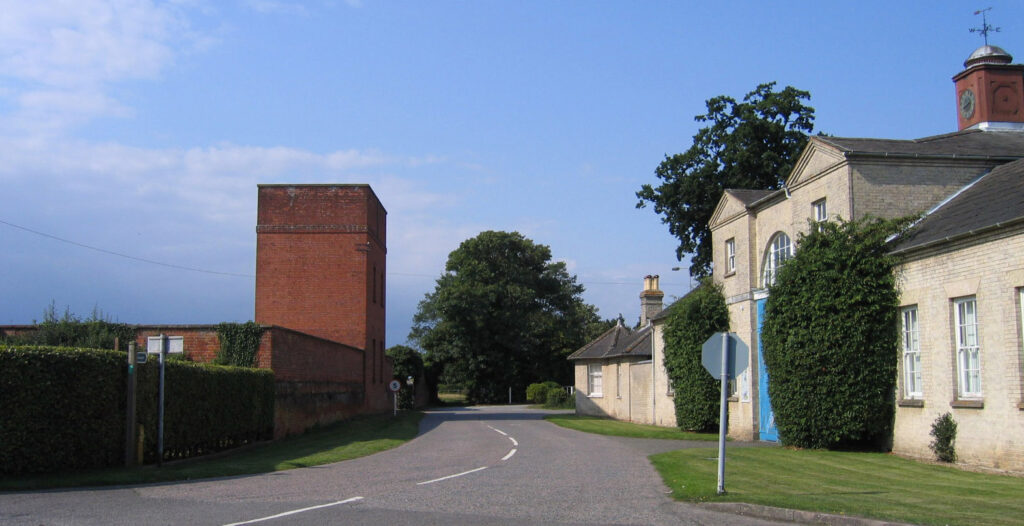
STABLE BLOCK
The stable block (Grade II) stands in a prominent position just west of the mansion and was built at the end of the eighteenth century. It has similar detailing to the mansion, suggesting it was designed at the same time by Jeffry Wyattville. There is a central two-storey, three-bay coach house flanked by single storey wings, plus a cupola with clock faces topped by a weathervane. The clock faces are believed to be much older than the cupola, possibly from the late 1600s, and came to Wherstead at the demolition of the West Gatehouse in Ipswich. The stable block was restored and converted to office space in 1976/7, at which time the wings were extended. Today it is still rented out as offices.
The 1839 tithe map depicts a courtyard to the west of the mansion and east of the stable block. This appears to be an entrance courtyard giving access to the west end of the service wing. An OS map dated 1882 shows the courtyard with a lean-to glasshouse along its north wall and a large freestanding glasshouse in the centre of the courtyard, possibly an orangery. With no other glasshouses on the site, this area must have been used to house tender plants and foodstuffs, vines and exotics destined for the household’s use. This arrangement appears to have continued well into the twentieth century, although all trace of the courtyard was lost when the office block was added in the middle of the century.
THE PARK AND GARDENS
In 1789, three years before work began on Wyatt’s new mansion, Humphrey Repton produced one of his famous Red Books entitled Wherstead, A Seat of Sir Robert Harland, Bart. in Suffolk. It showed the potential to develop the site using the fashionable ‘picturesque’ landscape style of the period. It is unclear whether all of Repton’s ideas were implemented, although they were probably influential in Sir Robert’s acquisition and demolition of the old vicarage next to the church in 1802, thus creating uninterrupted views towards the Orwell estuary from the mansion. A new vicarage was built on the southern boundary of the park. Although Home Covert north of the mansion appears to have been in existence before 1783, it is possible that clumps of trees, such as North Clump, were developed from Repton’s ideas for the creation of ‘middle distance interest’ in the landscape. In 1855 William White described Wherstead Park as ‘…a handsome mansion, and delightful grounds descending in verdant slopes to the Orwell estuary’.
At one time Repton’s Red Book for Wherstead was owned by Massachusetts Horticultural Society and was auctioned in the USA by Sotherby’s in 2008, although the buyer at the auction is unknown. Another Red Book was produced in the same year for Brook Hall Park, which lies on the opposite bank of the River Orwell and next to Orwell Park.
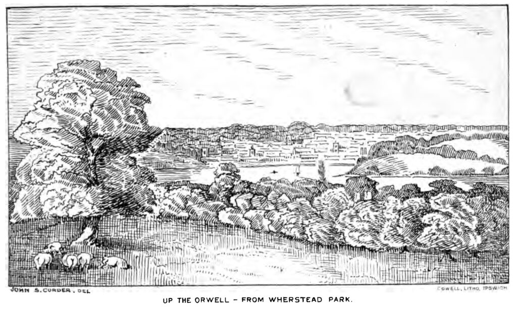
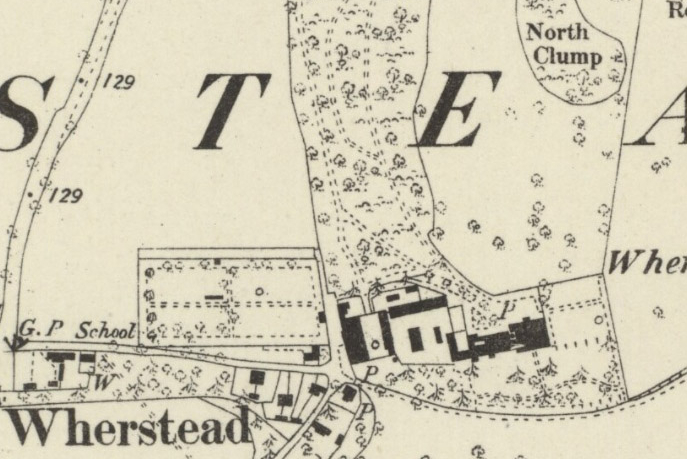
The 1884 OS map shows the mansion with a small lawn to the east giving extensive open views across parkland towards the Orwell River. To the south another lawn was enclosed by a narrow belt of shrubs and trees to give privacy from the track towards the church. Parkland dotted with freestanding trees stretched out to the north, east and south with a few small woods such as North Clump and Round Covert in the northern section and Icehouse Clump south of the house. As the name suggests, this surrounded an icehouse, the remains of which are believed to survive today. Curving in a large arc to the north of the mansion, Home Covert was formed by trees interspersed with tracks and paths.
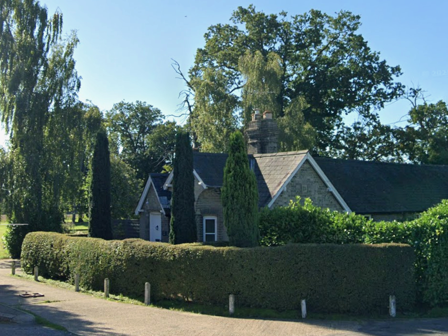
There were three entrance lodges, to the north, east and west. The lodge to the north was on the edge of Home Covert with a drive leading through the woodland to the house. The east lodge marked the eastern boundary of parkland close to Wherstead Hall. A further surviving lodge is on the western boundary of parkland, close to the mansion and beside the track leading eastward to the church.
By 1926 little change had taken place in the gardens and pleasure grounds layout of Wherstead Park, although North Clump had been expanded northward to become an extension of Home Covert. An undated postcard produced by Smiths Soutall of Ipswich shows that a croquet lawn had been installed in the gardens to the south of the mansion, with terraced grass to accommodate the change in site levels.
When Home Covert was cut off from the mansion site by the construction of the A14 leading to the Orwell Bridge in 1982, the tiny slice of the covert remaining between the road and the mansion was levelled and used for car parking, leaving just a few of the nineteenth century trees around the edge of the car park. By the twenty-first century a row of trees had been planted to mark the edge of the gardens to the east of the house that blocks the view over the former parkland, now cultivated fields, down to the River Orwell. This garden has been laid out with formal flowerbeds surrounded by grass with terracing and steps leading down to a lawn south of the house. Immediately north of the mansion there is a parking area with a lawn giving way to a small area of plantings, mainly dating from the twentieth century.

WALLED GARDEN
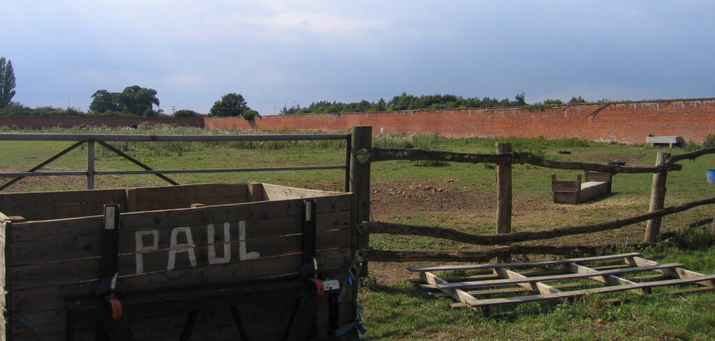
To the west of the stable block is a large rectangular walled garden with an area of c. 1.61ha (4a). Probably contemporary with the mansion, the walled garden’s tall red brick walls vary between 2.5m to 3m (8.2ft to 9.8ft) high. Writing in 1887 the vicar of Wherstead stated that the bricks had been made at the nearby Bourne Hill brickworks, at the time part of the Wherstead Park Estate. In 1884 the walled garden was divided into equal quarters by cross-paths with a perimeter path around all four sides. A further path led through the centre of the north wall and into a thin walled slip garden, although this outer wall had gone by 1967. Fruit trees lined the central north–south path, with further trees parallel to the north, south and west walls. At this time a freestanding cold frame is shown springing off the central path, although there were no other glasshouses within the garden because they were accommodated in the courtyard between the mansion and stables. A small pond or fountain stood in the adjacent segment.
A two-storey brick-built tower with tank to store water for the garden is attached to the walled garden’s eastern boundary wall and opposite the stable block. Water is believed to have been pumped from a stream c. 0.8km (0.5mls) away and storage racks for produce are housed in the lower part of the tower. Although the walled garden and tower are not listed in their own right, in 2008 Babergh District Council produced a Planning Position Statement. This concludes that due to its association with listed eighteenth century Garden Cottage (Grade II) – part of the south wall of the walled garden forming its rear boundary – the water tower and walled garden are classed as listed. The present c. 5m (16.4ft) entrance into the garden is close to the water tower with a pedestrian entrance at the east end of the north wall. Evidence remains of a blocked-up doorway centrally along this wall and opposite the route of an internal path shown on the 1884 OS map.
At a site visit in 2009 decaying wooden battening could be seen on the inside of the north wall suggestive of a protective system for tender wall plants such as early-flowering fruit, but with little further evidence elsewhere, either in or outside the garden, which at the time was often used to house cattle.
SOURCES:
Babergh District Council, Wherstead Office Park, Wherstead Planning Position Statement, February 2008.
Betham, Revd William, The Baronetage of England, or, The History of the English Baronets, Vol. 3, 1803.
Birch, Mel, Suffolk’s Ancient Sites – Historic Places, 2004.
Debrett, John, Debrett’s Baronetage of England, 1815.
Dictionary of National Biography, Vol. 19.
Fryer, Freda A., ‘Wherstead’ in East Anglian Magazine, April, 1951.
Kelly’s Directory of Suffolk, 1900.
Pevner, Nikolaus, The Buildings of England, Suffolk, 1974.
Saint Mary’s Church Wherstead, Suffolk, Brief History and Guide.
Wherstead Explorer walks leaflet.
White, William, History, Gazetteer, and Directory of Suffolk, 1855.
Zincke, Foster Barham, Materials for the History of Wherstead, 1887.
www.wherstead.com (accessed October 2013)
www.suffolkcoastandheaths.org (accessed October 2013)
http://www.esscrp.org.uk/gainsborough-line/gainsborough-history.html (accessed October 2013).
www.whersteadparksuffolk.coop/History.html (accessed July 2009).
www.artfact.com/auction-lot/repton,-humphry-1-c-blchvcrioj (accessed October 2013).
Conversation with owners of Garden Cottage at time of site visit in August 2009.
Census: 1911.
Maps:
1783 Hodskinson’s Map of Suffolk in 1783.
1839 (surveyed 1839) tithe map and apportionments.
1884 (surveyed 1881) OS map.
1904 (revised 1902) OS map.
1928 (revised 1924) OS map.
1947 (revised 1938) OS map.
2024 Google aerial map (Imagery © Bluesky, CNES / Airbus, Getmapping plc, Infoterra Lts & Bluesky, Maxar Technologies, Map data © 2024).
Heritage Assets:
Suffolk Historic Environment Record (SHER): WHR 044, WHR 061, WHR 066, WHR 094.
Wherstead Park (Grade II). Historic England No: 1281392.
Wherstead Hall (Grade II). Historic England No: 1281415.
Church of St Mary (Grade II*). Historic England No: 1204027.
Stable Block of Wherstead Park (Grade II). Historic England No: 1036939.
Garden Cottage (Grade II). Historic England No: 1351616.
Suffolk Archives (previously Suffolk Record Office):
(SA) HD 2833/1/SC461/1. Sales Catalogue for china, vases, plate, books and prints, bed linen from Wherstead Park. Vendor: exors. Of the late Sir Robert Harland Bt., May 1860.
(SA) HE 402/1/1891/16. Timber on Wherstead Park Estate, Vnedor: Chas. E. Dashwood, Esq., 25 June 1891.
(SA) K489/2/291. Edwardian photo of the lodges.
(SA) HG 400/2/311/1/12. Estimate for alterations and decorations to Wherstead Park, December 1915.
(SA) 2833/1/SC461/2. Sales catalogue of surplus household goods, 11 April 1934.
Site ownership: Company headquarters and offices
Study written: November 2025
Type of Study: Site visit 2009 and desktop
Written by: Tina Ranft
Amended:
