Parish: WISSETT
District Council: EAST SUFFOLK (previously Waveney)
TM 381 785
Not open to the public
Bordering the north-west outskirts of Halesworth, Wissett Hall (Grade II) is in elevated position on the Suffolk clayland plateau. It lies on the north side of the valley of The Beck, a small tributary of the River Blyth that flows eastward to the North Sea. The house is east of the main village settlement of Wissett in the far south-east of the parish where it borders Halesworth town boundaries. Said to be on the site of an earlier substantial property, the house has an early-seventeenth century core but was substantially altered and extended in the late-Victorian and early-twentieth century.
In 1841 Wissett Hall and a number of the surrounding fields were leased to Jonathan Howlett by the executors of the will of Isaac Wilcox. Jonathan was an auctioneer, who is later recorded as living at ‘Hill House’, another property to the north-west of the village and still owned by the Howlett family today. Lacking detail, the tithe map of that year shows a U-shaped house with side wings extending southward and west-facing entrance front. Its main garden elevation faced south with a terrace overlooking a small area of lawn and arable field beyond. The separate stable courtyard lay north of the house. From the road there were entrances flanked by trees to the south and north-west with an in-and-out drive that passed through a small park-like area to the west. A footpath lead from the house due west to the road. Pasture lay to the east, an orchard to the north and a field beyond named ‘The Grove’ on the tithe apportionment. The word ‘grove’ was usually used for an open and airy area of scattered trees and grassland used for grazing livestock. This is suggestive of wood pasture – an historic form of land management for the production of food and timber products from the same piece of land – and possibly dates back to the earliest years of a house on the site. The opening of the branch line of the Halesworth, Beccles and Haddiscoe Railway in 1854 to the east of the house must have disturbed the peace of this rural property.
By 1871 Jonathan Howlett had returned as the owner of Wissett Hall and was described as a farmer and landowner. The 1883 OS map shows a narrow shelterbelt of trees along the boundary with the road surrounding most of the western park-like area that would have given some privacy. The drives were lined with deciduous trees with a lone ornamental coniferous tree standing in front of the western entrance to the house. The eastern area of parkland was sparsely dotted with trees, also deciduous. A path lead from the rear of the house northward. It was flanked by ponds to the east and an orchard with a small building, probably a summerhouse, to the west. Beyond lay the ‘The Grove’ field with a marshy depression, which had been shown on the earlier tithe map and possibly representing an old clay pit, perhaps supplying the clay used to make bricks for the original house. A rectangular enclosure, not unlike a kitchen garden, lay to the north of the stable courtyard.
Although an exact date and architect are not given, the Historic England listing for Wissett Hall says it was enlarged in the late-nineteenth century, producing a timber-framed house encased in brick in the Arts and Crafts style. The alterations are said to have been done by ‘Herbert Groom’, although no record has been found for this person. However, the 1901 census lists a ‘Herbert Broom’ farmer and auctioneer’s clerk, as resident of ‘The Hall’ in Wissett, presumably the Wissett Hall property. Herbert was the son of a farmer with a substantial holding in Moulton St Mary, Norfolk. ‘Broom’ would seem to be the more likely name for this person.
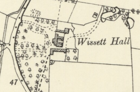
Four years later the 1905 OS map, surveyed in 1903, shows the drive and parkland layout remained much as it was twenty years earlier, albeit a number of additional coniferous and deciduous freestanding trees are marked on the map. The path leading due west is shown within a slight depression with embankments dotted with a mixed planting of specimen trees and north of the embankment is an area without any trees and suggestive of a flat lawn used for sporting activities such as tennis or crochet. The house and stable yard to the north are shown as separate buildings and south of the house the lawn was bordered by a field with a tree in the north-west corner and a square orchard lay to the east.
By 1911 Percy Balfour, a captain in the army, was living at Wissett Hall with his wife, two young children plus seven servants. On census night they had a visitor, Walter Sarel, listed as thirty-seven years old and an unmarried architect. Walter was born Henry Walter Molyneux Sarel (1873–1941) in Bickley, Kent but shortened his name to Walter Sarel in his professional life. He was known for remodelling sixteenth and seventeenth century houses in the Arts and Crafts style and often included designs for their gardens, influenced by and sometimes working with his friend Gertrude Jekyll, the well-known garden designer. Walter had recently extensively rebuilt neighbouring Spexhall Manor (Grade II) for Edmund Percy Calvert and his wife the Hon. Susan May Dutton Calver and it seems likely he was visiting in his professional capacity as an architect, perhaps suggesting alterations to the house and gardens.
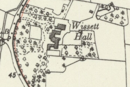
In 1917 Percy Balfour died in action in World War I and four years later the stockbroker Walter Scrimgeour (1852–1937) moved into Wissett Hall as the new owner where he lived with his wife Elizabeth (b. 1853). They are said to have moved from the Norfolk seaside resort of Hemsby, having previously come from Highgate in London. The 1928 OS map (revised in 1925) shows that alterations had been made to the house over the preceding twenty years and it seems possible that Walter and Elizabeth had made Hemsby a temporary home while building works took place. By this time the east wing of the house had been lost and the stable buildings and house were now joined to make a much larger house. At the same time alterations had also been made in the gardens with additional garden compartments or ‘garden rooms’ having been added. These included a surviving walled enclosure to the east of the house with crinkle-crankle walls to north, south and west, and an extension of the gardens by taking in part of the field beyond the old south lawn, with terracing and an additional lawn with a possible ha-ha marking the boundary between lawn and field. To the north-west part of an arable field had been incorporated into the gardens with lawn, belts of trees and a small building at the east end, possibly a summerhouse.
The Historic England listing for Wissett Hall states that a ‘Louis Sarel’ designed the distinctive circular tower linked to the north-east corner of the Wissett Hall. However, a ‘Louis Sarel’ is not listed as a practising architect by the Royal Institute of British Architects and an extensive search of censuses, births and deaths registrations plus other sources of documentary evidence have drawn a blank for the existence of a person named ‘Louis Sarel’.
The combined alterations to the house, including the addition of the circular tower, and the development of the gardens, with its mix of informal with more formal areas and garden compartments, show many of the characteristics associated with Walter Sarel’s other Arts and Crafts houses and gardens of the period, where work on the house went hand-in-hand with redesigning the gardens. His visit to the owners of Wissett Hall on census night in 1911, his work on neighbouring Spexhall Manor and the layout and style of the gardens at this time suggest Walter had either fully designed or advised on alterations to both house and gardens at Wissett.

Having spent some of his time at Wissett building up a prize-winning herd of red pole cattle, Walter Scrimgeour died in 1937 at the age of eighty-five and after his wife’s death in 1954 the Wissett Hall Estate was put up for sale and described as a ‘small residential estate’ of 43ha (106a) with house, grounds and ‘various gardens’, farm and four cottages. The gardens continued to be developed and expanded with Arts and Crafts principles in mind by following owners.
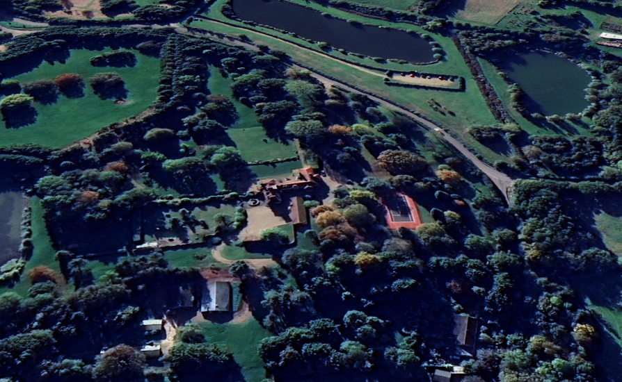
Wissett Hall was for sale c. 1980, and again c. 2019 when the parkland and grounds now extended to 9ha (22a). By this time surrounding arable fields had been converted to wooded parkland, described in the sales particulars as mature, with an equally mature avenue of trees lining the main drive from the south. A 0.4ha (1a) lake stocked with fish was created in the parkland east of the house. The gardens around the house have continued to be maintained as separate areas with rose garden, formal box garden and within the walled garden there are clipped hedging, flowerbeds, vegetable garden and swimming pool.
SOURCES:
Kelly’s Directory of Cambridge, Norfolk and Suffolk, 1922.
Norfolk Landowners Record for 1871.
Savills Sales Particulars, 2019.
White, William, History, Gazetteer & Directory of Suffolk, 1844, 1874.
Wissett Draft Conservation Area Appraisal, 2019, East Suffolk District Council.
Information about the life and work of Walter Sarel in Compton Rectory, a purpose-built rectory designed by the London architect Walter Sarel (1873-1941) in an Arts and Crafts style https://historicengland.org.uk/listing/the-list/list-entry/1434120?section=official-list-entry (accessed November 2024) and https://www.parksandgardens.org/people/henry-walter-molyneux-sarel (accessed June 2023)
Riba Collections website shows no entry for a Louis Sarel and Historic England cross-referencing to Spexhall Manor refers to Walter, not Louis Sarel. https://riba.sirsidynix.net.uk/uhtbin/cgisirsi/?ps=AXQn3E34Ll/MAIN_CAT/X/60/53/X (accessed November 2024)
Halesworth Museum https://www.halesworth.net/history/ (accessed January 2023)
Halesworth Museum https://www.halesworth.net/history/Economic_and_Social_History_of_Halesworth.pdf (accessed January 2023)
‘The Skirmisher, The Bulletin of the Scrimgeour Clan Association’ No. 29, 2007. https://citeseerx.ist.psu.edu/document?repid=rep1&type=pdf&doi=21178a1b11c7e758acf0aec6f3721f08e2628182 (accessed November 2024)
Census: 1871, 1881, 1891, 1901, 1911.
1841 (surveyed 1839) tithe map and apportionment.
1883 (surveyed 1882 to 1883) Ordnance Survey map.
1905 (revised 1903) OS map.
1928 (revised 1925) OS map.
2021 Google aerial map (Imagery © Bluesky, CNES / Airbus, Getmapping plc, Infoterra Lts & Bluesky, Maxar Technologies, Map data © 2021).
Heritage Assets:
Suffolk Historic Environment Record (SHER): WSS 036.
Wissett Hall (Grade II). Historic England No: 1285667.
Spexhall Manor (Grade II). Historic England No: 1283610.
Suffolk Record Office (now Suffolk Archives):
SRO (Lowestoft) 1013/2/11 and 13 Conveyance Rumburgh Town Feoffment Leases etc, 26 March 1866 and 31 December 1867.
SRO (Ipswich) HE402/1/1954/33. Sales Particulars, 1954.
SRO (Ipswich) HD2833/1/SC471/1. Sales Particulars, c. 1980.
Site ownership: Private
Study written: February 2025
Type of Study: Desktop
Written by: Tina Ranft
Amended:
