Parish: WORLINGHAM
District Council: EAST SUFFOLK (previously Waveney)
TM 442 901
Not open to the public except for private hire, weddings, parties and holiday accommodation
The parish of Worlingham lies in the valley of the River Waveney, which separates Suffolk from Norfolk, c. 13km (8ml) south-west of Lowestoft and today on the eastern outskirts of Beccles. The village and Worlingham Hall (Grade I) are c. 10m above sea-level, the land sloping northward down to the floodplain of the river where terrace heaths were once exploited as common grazing land by farmers, much of which was incorporated into the landscape park of Worlingham Hall. Its southern entrance was originally opposite the medieval All Saints Church (Grade I). The village was previously on the main road between Lowestoft and Beccles but is now bypassed to the north, cutting through part of the late-eighteenth/early-nineteenth century landscape park of the Hall.
OWNERS OF WORLINGHAM ESTATE
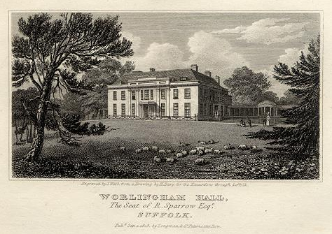
The estate was owned by the Duke family until the mid-seventeenth century when it was bought by John Felton, Esq., the youngest son of Sir John Felton, Knt of Playford Hall, who built the original mansion on the site. On his death it passed to his daughter who sold to Sir Thomas Robinson, Bart, grandson of Sir Thomas Robinson, Knt of Kentwell Hall, Long Melford, who made it his chief residence. After the death of Sir Thomas, the estate was bought by Robert Sparrow, Esq., whose son, also Robert inherited in 1766 and some thirty years later completely remodelled the house. Robert was known as a man of taste but described by his land agent as ‘a man of considerable Talent, but wanted to make every one afraid of him’. In 1822 the Worlingham Estate passed to Mary, Robert Sparrow’s only daughter, and later to her husband Archibald Acheson, second Earl of Gosford. The c. 1,133ha (2,800a) estate was sold by Archibald in 1849, passed through several hands and had long periods of being unoccupied with it gradually broken-up and sold.
By 1962 the Hall was in need of a full restoration when the task was taken on by the Fourth Viscount Colville. With restoration still unfinished, the mansion with only c. 8ha (20a) of parkland was sold in the late 1990s to Richard and Fiona Nourse, who set about buying back some of the parkland previously lost so that by the time it was for sale in 2010 the estate had been expanded further to include a large lake, marshes, woods and an area of conservation woods and wetland to create a conservation and sporting estate. It was again for sale in 2019, since when the Hall has been used as an exclusive country house available for private hire, weddings and parties, with further holiday accommodation in surrounding converted buildings.
THE HALL
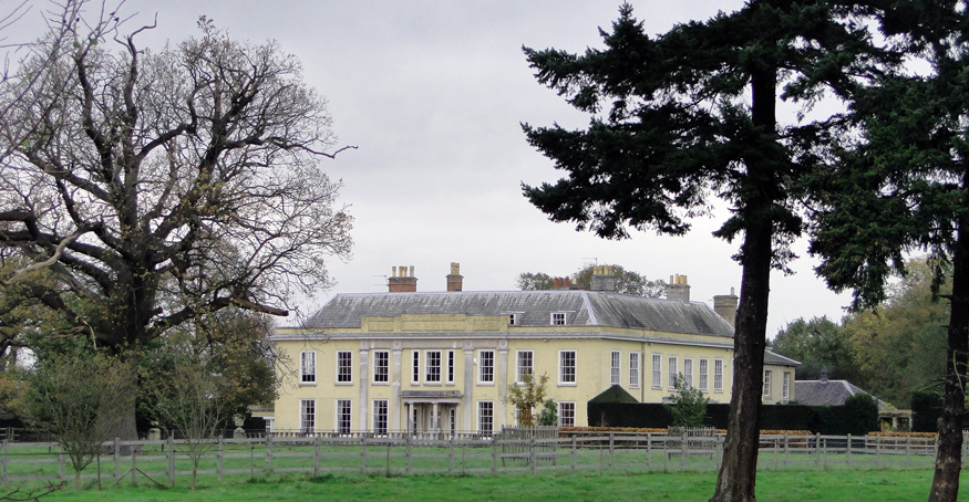
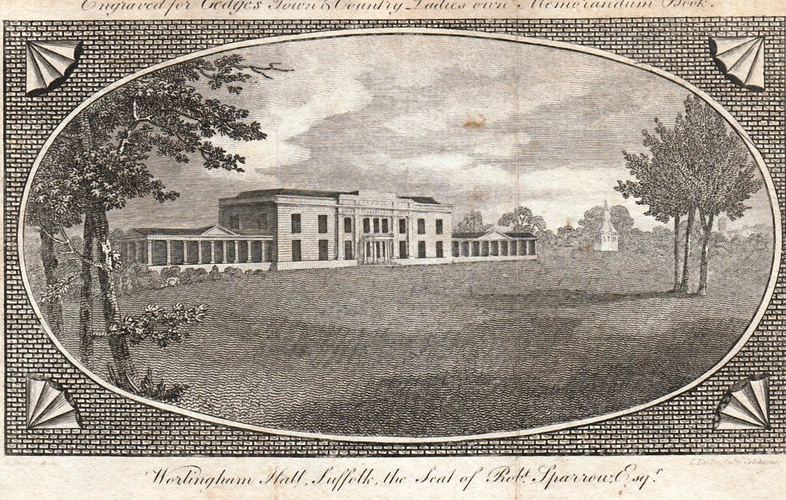
In 1785 Robert Sparrow commissioned the well-known architect John Soane to prepare plans for a new mansion, but these were not implemented. Instead c. 1800 John Felton’s original house was enlarged and remodelled in the Georgian style to designs by the Irish architect Francis Sandys whose other Suffolk commissions included Ickworth House for the Fourth Earl of Bristol, Tendring Hall, Stoke-by-Nayland for Sir Joshua Rowley and Great Finborough Hall for Roger Pettiward. However, it has been suggested there are several features of the house that indicate a Soane influence. Whilst evidence of the original red brick house remains to the rear, attention was concentrated on the three sides that were most likely to be seen. The exterior was described by Eric Sandon as ‘unadorned simplicity’ that contrasts with the ‘considerable richness of the interior’, including the dramatic central octagonal staircase with domed roof lit by lantern. The almost square main block faces south and was flanked to the west by a surviving eleven-bay orangery leading to a picture gallery and to the east by an open fronted colonnade with a small domed conservatory along its length. The stable block and offices were situated to the north of the house.
The house changed little over the following two hundred years, although by the early part of the twentieth century the orangery had acquired a return wing and the colonnade was shortened and lost its domed conservatory. As the estate contracted the house deteriorated and by 1962 was in need of major restoration that was done by Viscount Colville over the following thirty years. Since then further renovation has taken place to re-create this classic Georgian house. By the end of the twentieth century the rear courtyard included stabling, garages, a coach house, store and workshop, plus three cottages, which have since been converted to guest accommodation.
THE PARK
In the 1780s the park at Worlingham covered c. 18 ha (44a), but the enclosure of Worlingham common in 1787 allowed Robert Sparrow to expand his park at about the same time as the house was remodelled. Most of the common was planted with trees to create a wood, described by Henry Davy in 1827 as ‘…greatly improved by the late proprietor Robert Sparrow (d. 1822), who showed much taste in the arrangement of the plantations and the general disposition of the grounds’.
An engraving from the early 1800s shows the Hall and its side wings with a dovecote on a hexagonal base with spired roof in a simple parkland scene with no visible pleasure gardens. It lay north-east of the mansion and was named ‘Dove House’ on the 1840 tithe apportionment, but had gone by the time of the 1884 OS map. The tithe map also shows an ‘Ice House’ slightly further north and on the edge of a wooded area that became known as ‘Icehousehill Covert’. The 1849 sales particulars described the ice house as ‘screened by dark pines’ and secluded walks of pine, oak and yew mingled with larch, birch and Spanish chestnuts. Still named on the 1884 map, the ice house was lost soon after.
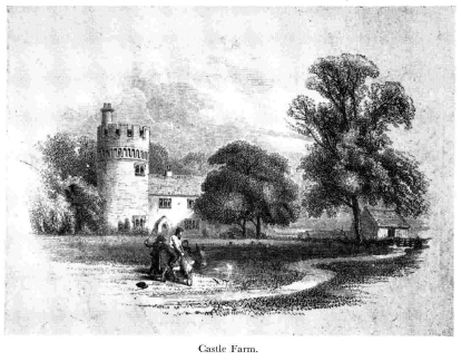
By 1840 the landscape park had expanded to c. 42 ha (104a) with an additional c. 50ha (125a) of woodland adjoining the river marshes. It appears to have been designed on picturesque principles with sales particulars of 1849 describing the gamekeeper’s cottage as of ‘Norman style’ and designed to be a ‘picturesque object from the park’. Not marked on nineteenth century maps, it is unclear where this was located, although it seems likely it was the castle folly named ‘Castle Farm’ illustrated and referred to by Norman Scarfe in an article for Suffolk Institute of Archaeology and History in 1959. This is described as being viewed from the mansion and by the time of the article was situated near a housing estate, which may relate to a possible building in a clump of trees shown on the 1840 tithe map in the parkland south-west of the house.
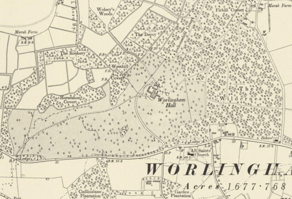
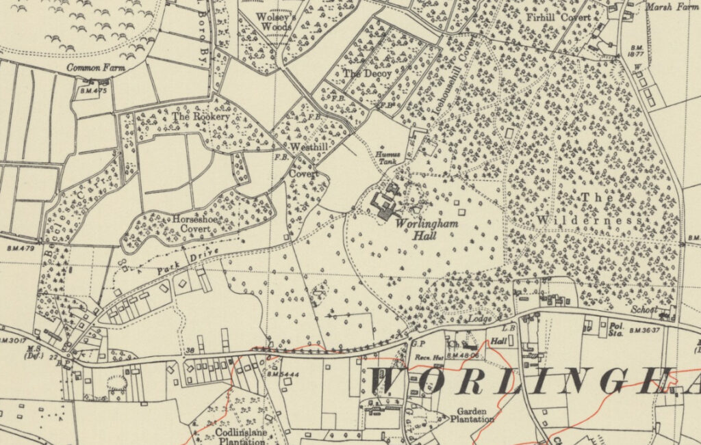
The parkland surrounded the house, extending south-west and south towards the Beccles to Lowestoft road and north towards the river. By 1840 there were belts of trees in the south-east corner and to the north and west of the house. The eastern section of parkland became woodland with tracks and was renamed ‘The Wilderness’ during the second half of the nineteenth century. In 1855 William White described it as ‘an extensive and well-wooded park’. Two entrances along the Beccles to Lowestoft road are shown on the tithe map with an in-and-out drive to the south front of the mansion. With its entrance just east of the parish church, the south drive, wound through a belt of trees that opened out to give views of parkland with the house beyond. The other entrance was to the south-west with a long drive sweeping through the parkland. By 1840 both entrances had lodges, although the course of the main southern drive subsequently moved slightly west leaving the original southern lodge isolated from the drive in a clump of trees. By 1906 the southern drive had been diverted within the park so that it curved slightly westward in front of the mansion to join the other drive, thus leaving the area immediately south-east of the house as uninterrupted open parkland. Both lodges appear to have survived into the twenty-first century, albeit greatly altered and enlarged until they are hardy discernible as the nineteenth century lodges.
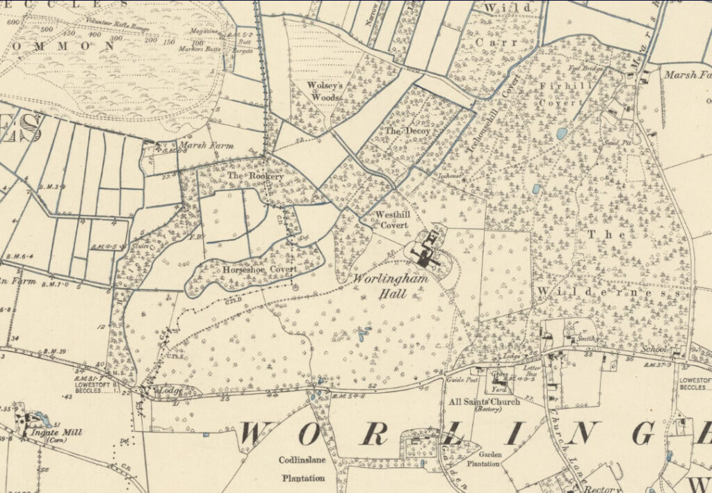
‘Decoy Plantation’ is shown on lower ground north of the house on an early OS map. It was renamed ‘The Decoy’ on the 1884, 1906 and 1947 maps, although shown as woodland with paths and a peripheral drainage ditch without a pond, as it has remained into the twenty-first century. The 1840 tithe apportionment describes the area as ‘weed’, suggesting a previous decoy pond had become overgrown by the early-nineteenth century. The Worlingham Hall Estate included Worlingham Staith, a quay on the Waveney River, but described in 1849 as ‘a forlorn mud-bank’. It was advertised in sales particulars with an illustration of a boat-house, two ladies being rowed on the river and another with parasol in a sailing boat. This may have been at Worlingham Mill, north-east of the house.
THE PLEASURE GARDENS
The tithe map of 1840 shows the mansion surrounded by a lozenge-shaped garden enclosure, although the stables and offices sat outside to the north. The enclosure represents the extent of the formal gardens throughout the nineteenth century with parkland immediately in front of the south elevation. By 1906 the gardens had also extended up to the eastern garden elevation and during the early 1900s a small area of garden with a pond and shrubbery developed slightly to the north-east of the mansion with paths towards the ‘Wilderness’ and ‘Icehousehill Covert’.
By the beginning of the twenty-first century the formal gardens had expanded further to the east of the house and beyond the nineteenth century enclosure to include a lawn and tennis court bordered by yew hedges, with the north-eastern garden area also extended. To the west, beyond the orangery, a further lawn surrounded by herbaceous borders and yew hedging had developed. In front of the main south elevation there is a car parking area surrounded by a relatively new ornate balustraded wall.
WALLED KITCHEN GARDEN
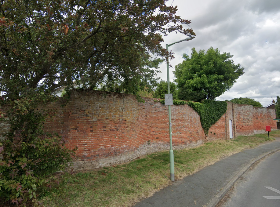
There appears to have been a walled enclosure to the rear of the orangery during the nineteenth century, by 1906 its western arm having been converted into a building. This may have been part of the offices serving the house or perhaps an ornamental or kitchen garden. However, there was another walled garden outside of the park to the south of the Lowestoft to Beccles road and west of the parish church of All Saints. It was named ‘Hall Garden Cottage & land’ on the tithe apportionment and owned and occupied by the Earl of Gosford. This would have been the principle kitchen garden for the Hall with access from the house via the southern drive. Rectangular in shape, in 1884 the enclosure had glasshouses and back sheds attached to its northern wall and a central dipping pond, all elements of a classic Victorian kitchen garden. The garden survived until the second half of the twentieth century, although today it is the site of housing and only some remains of late-eighteenth or early-nineteenth century crinkle-crankle red brick walls, gateway and a straight section of wall (Grade II) survive as boundaries for some of the houses.
SOURCES:
Burke, Sir Bernard, A Genealogical and Heraldic Directory of the Peerage Baronetage, 47th edition, 1885.
Burke’s Landed Gentry, 1914, Part 1.
Churchill, Penny, ‘The journey of a beautiful Suffolk estate from a crumbling ruin to modern masterpiece, with a 448-acre conservation and sporting estate’ in Country Life, June 2019. (https://www.countrylife.co.uk/property/journey-beautiful-suffolk-estate-crumbling-ruin-modern-masterpiece-448-acre-conservation-sporting-estate-198219 accessed November 2020)
Davy, Henry, Views of the seats of noblemen and gentlemen in Suffolk, 1824–26.
East Suffolk Local List: Historic Parks and Gardens, November 2021 for East Suffolk District Council.
Fox-Davies, Arthur, Charles, Armorial families: a directory of gentlemen of coat-armour, 1905.
Gedges, Town & Country Ladies’ own Memorandum Book, c. 1809.
Page, Augustine, Topographical and Genealogical, The County of Suffolk, A Supplement to the Suffolk Traveller (of J. Kirby), compiled 1811 and published in 1844 by Page, Joshua.
Payne-Gallwey, Sir R., The Book of Duck Decoys, 1886.
Sandon, Eric, Suffolk Houses. A Study of Domestic Architecture, 1977.
Scarfe, Norman, ‘Whitney and Read: Two Regency Estate-Agents. With a short account of the Worlingham Estate 1755–1851’ in Suffolk Institute of Archaeology and History Proceedings, Vol. XXXVIII, Part 2, 1959.
Walford’s County Families of the United Kingdom, 1880.
White, William, History, Gazetteer, and Directory of Suffolk, 1855.
Williamson, Tom, Suffolk’s Gardens & Parks, 2000.
Sir John Soane’s Museum Collection Online. http://www.soane.org/collections (accessed October 2021).
Suffolk Landscape Character Assessment https://suffolklandscape.org.uk/landscapes/rolling-valley-farmlands-furze/ (accessed November 2020).
Census 1861, 1881, 1901, 1911.
Hodskinson’s Map of Suffolk in 1783.
1840 (surveyed 1840) tithe map and apportionment.
1884 (surveyed 1883) Ordnance Survey map.
1906 (revised 1903) OS map.
1929 (revised 1926) OS map.
1947 (revised 1938) OS map.
1951 (revised 1947) OS map.
2022 Google aerial map (Imagery © Bluesky, CNES / Airbus, Getmapping plc, Infoterra Lts & Bluesky, Maxar Technologies, Map data © 2022).
Heritage Assets:
Suffolk Historic Environment Record (SHER): WGM 004, WGM 005,WGM 025.
Worlingham Hall (Grade I), Historic England No. 1032013.
Garden Lane Serpentine wall together with adjoining straight wall and second serpentine wall (Grade II), Historic England No. 1032014.
Church of All Saints (Grade I), Historic England No: 1182968.
East Suffolk Local List: Historic Parks and Gardens, November 2021 for East Suffolk District Council. (Review of five Historic Parks and Gardens in former Waveney area identified as Non-designated heritage assets)
Suffolk Record Office (now Suffolk Archives):
SRO (Lowestoft) 180/1. Map, sales particulars and conditions of sale of the Worlingham Estate, 21 August 1849.
SRO (Lowestoft) 167/N/1/1. Plan of Worlingham Hall Estate, 1914.
SRO (Lowestoft) 191/1/2. Sales particulars for Worlingham Hall, 1959.
SRO (Lowestoft) 1117/481/8. Sales particulars for Worlingham Hall, undated [1994].
Site ownership: Private
Study written: March 2023
Type of Study: Desktop
Written by: Tina Ranft
Amended:
