(formerly Wortham Hall and also known as The Manor House)
Parish: WORTHAM
District Council: WEST SUFFOLK
TM 078 797
Not open to the public
In the far north of the parish of Wortham, Wortham Manor (Grade II*), also known as The Manor House, lies close to the River Waveney, the boundary between Suffolk and Norfolk. It is c. 10km (6mls) north-west of Eye and c. 6.5km (4mls) from Diss in Norfolk.
Once two parishes with their own church and parsonage, Wortham Abbots (Everard or Southmore) and Wortham Hall (Jervis or Eastgate) were combined in 1769. The Saxon church in Wortham Abbots disappeared leaving only the Church of St Mary the Virgin (Grade I) standing in the north-east corner of the parish. This has a partially collapsed large round tower dated to the twelfth century and believed to be the largest Norman round tower in England.
Part of the gently undulating parish lies on the High Suffolk clayland plateau with the northern section bordering the Waveney river valley where soils are sandy and acidic, an area historically the focus for settlement. The parish consists of small hamlets and isolated properties. In the north-east of the parish and east of Wortham Manor, Wortham Ling is an area of Special Scientific Interest (SSSI), this dry common heathland has been preserved because it was deemed unsuitable for enclosure and conversion to arable. The parish once had three blocks of ancient woodland – Great Wood and Little Wood in the north-west, Grittin Wood in the south – but only the latter has survived into the twenty-first century.
The Wortham Manor Estate was owned by the Betts family from c. 1490 to c. 1907 and is believed to have once included parts of the Waveney valley, where it is said a ship burial was found in the meadows. Originally named Wortham Hall and the manor house for the original Jervis or Eastgate parish, the house changed its name to Wortham Manor in the early-nineteenth century.
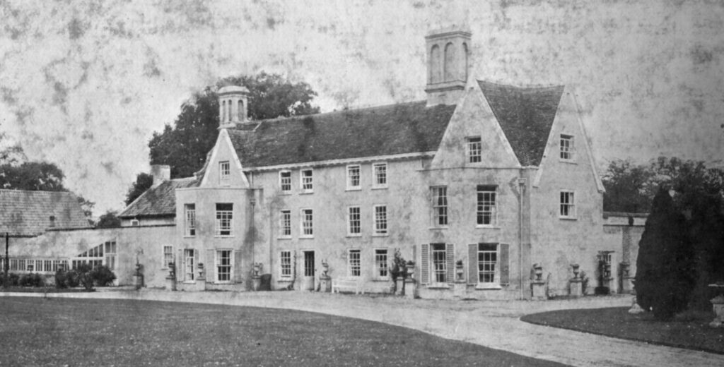
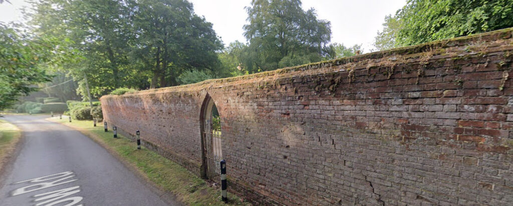
With earlier origins, the timber-framed house dates from the mid-seventeenth century, but was altered in the eighteenth and extended in the nineteenth centuries, although it retains a seventeenth century appearance with its Queen Anne south frontage. The house lies adjacent to a small lane running east to west, its northern rear elevation immediately along the road. A few windows along this elevation have views northward over meadow and grazing land. The main house elevation faces south and overlooks a small park and a Victorian glasshouse survives attached to the west end of the house. Attached to the east end of the house there is a red brick 3m (10ft) high boundary wall with a small arched gateway into the pleasure garden that developed with the house from the seventeenth century onwards.
Hodkinson’s map of 1783 shows it as an un-named house, the home of ‘Rev. M. Betts’. It passed through the Betts family, including the Revd Thomas D’Eye Betts who let the manor house when he moved south to take up the family living in Martlesham after the death of the Revd G. C. Doughty in 1832. By the time of the tithe map of 1838 the gardens and parkland to the south of the house had developed. The main features were a surviving small area of formal gardens – certainly of a nineteenth century date but likely to be earlier – east of the house behind the boundary wall and to the south, a formal layout of an oval pond on the central axis of the house flanked by two parallel lines of trees at wide intervals in parkland.
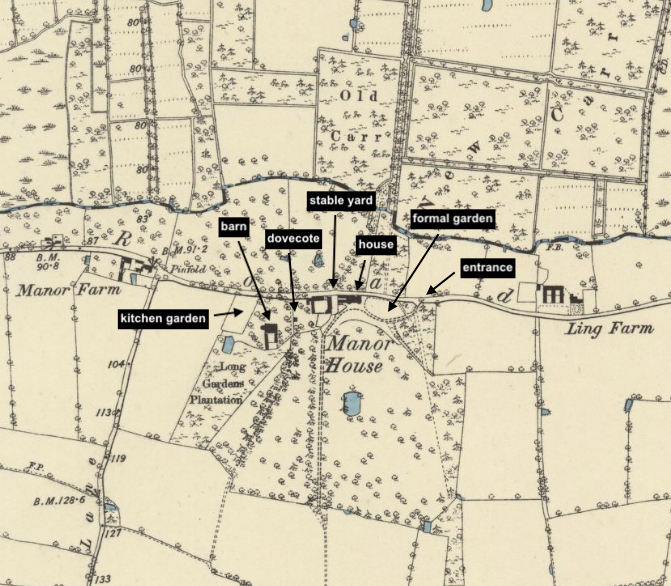
The 1885 OS map shows that the pond shown on the 1838 tithe map is still present, although the lines of parallel trees have gone to be replaced by a less formal parkland dotted with freestanding trees, mostly deciduous with occasional coniferous trees. A curving entrance drive from the east passes in front of the house before turning south to become a track lined with trees towards the church. The small area of formal gardens is to the east of the house shown on the 1838 map survives as does a triangular plantation by the entrance. West of the house are the stable yard with enclosure behind, small barns and then a large barn set in a meadow from where a tree-lined track passes through the parkland southward. Further west is a parallelogram-shaped large kitchen garden. This was shown on the tithe map to have a perimeter path with cross-paths creating eight sections. It is not clear if this was walled. Behind the kitchen garden and barn meadow is surviving ‘Long Garden Plantation’ with a mixed planting of deciduous and coniferous trees. This was shown on the tithe map to have had a path curving through it from the kitchen garden to the enclosure behind the stable yard. An undated photograph of a small dovecote, said to be from Wortham Manor, may be the small building shown to the west of the stable courtyard that survived into the twentieth century but has now gone.
Descending through the family, by the end of the nineteenth century it was the home of Harriett Betts and after her death eventually sold to Mr Beaumont of Coggleshall in 1907. In 1911 it was the home of retired wine merchant Paul Bradshaw and his family followed by Paul B. Fearon.
By the 1930s the novelist Doreen Wallace (Rash) lived with her farmer husband Roland Rash at Wortham Manor. Not only was she a prolific writer whose books often dealt with the countryside, she was also a teacher and social campaigner known as an agitator against high tithe taxes that farmers were required to pay to the church. This resulted in a demonstration and barricade of the manor when bailiffs arrived after Doreen and Roland’s refusal to pay the tithes. Ultimately, in 1939 a tithe bankruptcy sale of the furniture and effects was held in the grounds of the manor house. Hundreds of farmers came to support Doreen and it was reported that Mr S. W. Mobbs of Lowestoft bought every one of the lots and returned them to the house.
The property has changed hands on a number of occasions since. It was for sale c. 1985 when the sales particulars describe it as a country house with cottage, range of outbuildings, gardens and grounds, woodland, all totalling c. 8ha (20a). More recently it was once more for sale in 2015.
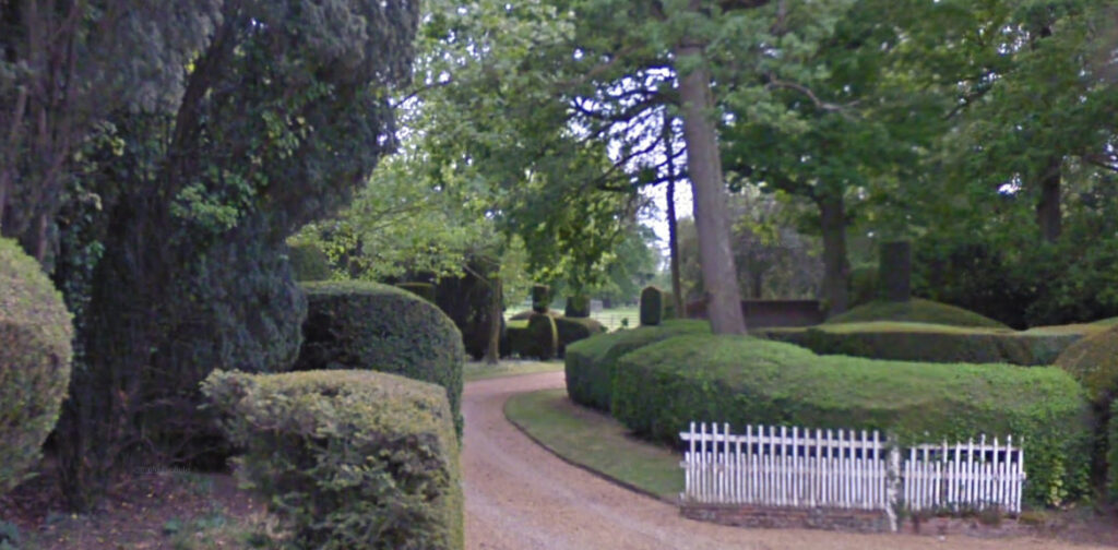
An ornamented octagonal ashlar sundial (Grade II) with eighteenth century stem and nineteenth century finial survives in the formal garden of clipped box and yew interspersed with trees, including plane and lime, c. 40m east of the house. Known to have been in existence in 1838, it is likely this garden dates back to the eighteenth century. The north and east ranges of the stable courtyard survive, the large western barn with thatched roof is now in separate ownership and has been converted for residential use and the kitchen garden enclosure beyond has gone, to be replaced by a tennis court and now part of the gardens for the barn conversion. A lawned area has been created immediately in front of the house, separated from the parkland by a fence. Within the parkland the pond survives, albeit now surrounded by shrubs and trees, and some late-nineteenth century parkland trees have also survived including oak and lime trees.
SOURCES:
Birth, Mel, Suffolk’s Ancient Sites, Historic Places, 2004.
Copinger, W. A., The Manors of Suffolk, Vol. 3, 1905.
Country Life, December 2015, https://www.countrylife.co.uk/property/three-listed-country-houses-for-sale-81245/attachment/wortham-manor-main (accessed August 2021).
Doughty, Katherine, Frances, The Betts of Wortham in Suffolk, 1480–1905, 1911.
Kelly’s Directory of Suffolk, 1921.
Suffolk County Council, Suffolk Landscape Guidance, 19 Guidance Note Rolling Valley Farmlands and Furze, EP/Edit/1.10.10.
Waikato Times, Volume 125, Issue 20886, 18 August 1939, page 12, © Stuff Ltd, https://paperpast. Natlib.govt.nz/newspapers/WT19390818.2.51 Reproduced under Creative Commons BY-NC-SA 3.0 New Zealand (accessed August 2021).
Walford, Edward, The County Families of the United Kingdom,1893.
Williamson, Tom, Suffolk’s Gardens & Parks, 2000.
https://friendsofworthamchurch.weebly.com/history.htmlWortham church – a brief history (accessed August 2021).
Census: 1841, 1861, 1881, 1891, 1901, 1911.
Maps:
1783 Hodskinson’s Map of Suffolk in 1783.
1840 (surveyed 1838) tithe map and apportionment.
1885 (surveyed 1885) Ordnance Survey map.
1905 (revised 1903) OS map.
1952 (revised 1950) OS map.
2015 LiDAR image. (Crown Copyright Scottish Government, SEPA, Fugro and Scottish Water 2012–2022)
Heritage Assets:
Suffolk Historic Environment Record (SHER): WTM 011, WTM 028.
The Manor House (Grade II*), Historic England No. 1032738.
Church of St Mary the Virgin (Grade I), Historic England No. 1032741.
Sundial about 40 metres east of The Manor House (Grade II), Historic England No. 1032739.
Historic England Monument No: 387134.
Suffolk Archives: (formerly Suffolk Record Office):
(SA) HD 4084/31. Betts family of Yoxford and Wortham, 1649–1826.
(SA) HD 2833/1/SC484/3. Sales particulars of Wortham Manor, c. 1985.
Site ownership: private
Study written: January 2026
Type of Study: Desktop
Written by: Tina Ranft
Amended:
