(demolished 1925)
Parish: SANTON DOWNHAM
District Council: WEST SUFFOLK (formerly Forest Heath)
TL 812 876
Thetford Forest open to the public
Downham Hall, demolished in 1925, once stood in the small hamlet of Santon Downham in an area described as ‘Estate Sandlands’ in north-west Suffolk. It was just south of a large meander of the Little Ouse River, the border between Suffolk and Norfolk, lying on the edge of the river’s flood plain. It should not be confused with Santon, which is north of the river in Norfolk. Thetford is c. 10.5km (6.5mls) to the south-east and Brandon c. 3.2km (2mls) south-west. The area is generally a flat plateau of free-draining sandy soils, creating the once-extensive areas of heathland historically used for sheep grazing or rabbit warrens.
Downham Hall’s home farm and the medieval Church of St Mary (Grade I) were nearby, a grouping indicating a medieval manor house and church. During the late medieval period the manor of Santon Downham was mainly held by Bury St Edmunds Abbey and then passed through the de Vere family before it was subdivided into a number of sub-manors, when Downham Ixworth manor was given to Ixworth Priory in the mid-thirteenth century. After the Dissolution of the Monasteries in the sixteenth century John Kirby in his The Suffolk Traveller writes that one of the sub-manors was granted to Sir Thomas Kytson and another to Richard Codington (d. 1567) of Ixworth.
In the early-seventeenth century open areas of Thetford became important royal hunting grounds, especially for King James and King Charles. A 1636 warrant was issued for the preservation of the king’s game ‘of hare, partridge and other wild fowl’ in a twelve mile radius of Thetford, which would have included Santon Downham.
By the middle of the seventeenth century Downham Hall was owned by the Wright family, wealthy local landowners who stayed at Downham for more than one hundred and fifty years. In 1668 Thomas Wright announced that a ‘sand flood’ that had been continuing over a number of years had reached the village, buried a number of the village houses and nearly buried his own home, a substantial building that was recorded in 1674 as having twelve hearths. In an effort to protect his house he is said to have created embankments around it using a mixture of furze, sand and earth. To access his house he cut through the embankments.
In 1778 Charles Sloane Cadogan (b. 1728), the 1st Earl of Cadogan, bought the Downham Hall Estate of c. 1,268ha (3,134a) and used the house as a shooting lodge. At the time of the sale the Ipswich Journal described Downham Hall as ‘Mansion sashed, fronting South, with all conveniences, gardens, meadows etc… rights of fishing and swanning’. With the rise in popularity of game shooting by the gentry, low land prices in the area and sparse population gave opportunities for the formation of parks, which happened in Santon Downham during the eighteenth century.
A map dated 1778 shows the estate had ‘warren banks, doles [temporary allocated common land], roads and track’. A number of earthworks of mounds and banks for the rabbit warrens have been recorded in the area and the warrens are today remembered in areas of Thetford Forest around the village such as ‘Brandon Warren’, ‘Downham Highlodge Warren’, ‘Thetford Warren’ and ‘Downham Warren’, the latter in an area south-east of the village beside the river and close to today’s Little Lodge Farm.
Before buying Downham Hall Estate, Charles Sloane Cadogan was Surveyor of the King’s Garden between 1764 and 1769 and is known to have been in contact with the famous landscape designer Lancelot ‘Capability’ Brown. Lancelot had been called on the modernise the park at Cavenham Park, now in Berkshire, the Cadogans family home in the mid-1760s. So, although Lancelot died in 1783, five years after Charles Soane bought the Downham Hall Estate, it is possible he offered specific advice to Charles regarding landscaping of the park at Santon Downham, or perhaps his ideas may have filtered down to influence it.
It is recorded that there were numerous new tree plantations around this time and Hodkinson’s 1783 map shows a small area of pleasure grounds and parkland around the house with an avenue of trees running south-westward towards Brandon, today known as ‘Hereward Way’, with a triple avenue on the central axis of the house running southward for a short distance into heathland.
Charles was a Whig politician, becoming MP for Cambridge. Ever the opportunist, he was part of a syndicate who bought a c. 130ha (320a) estate in St George Parish, Grenada including its slaves. The Cadogan family had an estate in Chelsea, London, part of it was leased to architect Henry Holland who built Sloane Square, Sloane Street, Cadogan Place and Hans Place. Charles died at Santon Downham in 1807 and the title and various properties, including the Downham Hall Estate, passed to his eldest son, Charles.
A report dated 1829 described Downham Hall as ‘a modern house of apparently the former part of the last century’ and undated photographs of the house, probably late-nineteenth or early-twentieth century, show a building with many Georgian features. This suggests that the Cadogans either replaced the Wrights mansion or perhaps Georganised the existing house.
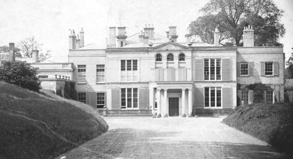
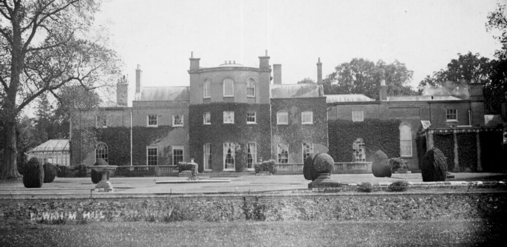
In 1830 the estate was bought by Lord William John Frederick Powlett (d. 1864), later Duke of Cleveland, who employed the architect Lewis Vulliamy to make alterations to the house, including adding a portico onto the front entrance. Six years after William’s death the estate was on the market in 1870 and bought by the wealthy Edward Mackenzie (1811–1880) of Fawley Court near Henley-on-Thames and became the home of Edward’s second son Col. Edward Philippe (1842–1928) who had the right of residence for his lifetime when it would revert to Edward’s eldest son William. In 1892 Kelly’s Directory of Suffolk recorded the estate as being well-wooded with extensive game reserves and 3.2km (2mls) carriage drives and entrance lodges, one to Thetford and the other to Brandon. These had been the original public roads that were taken into the landscape park at the end of the eighteenth century. The brick and flint lodge at the end of the southern drive survives today, although much extended. Visible as an earthwork on recent aerial photographs, a curved bank north of the house is believed to be the remains of a ha-ha separating the formal gardens from the parkland beyond, probably an early feature of the landscape park.
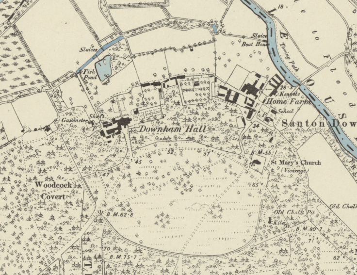
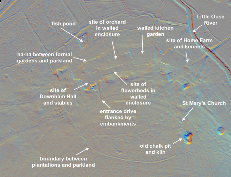
The 1884 OS map shows the south drive leading to the house flanked by trees. As the drive gets closer to the house it is shown on the photograph of the entrance front as being unusual embankments at a higher level than the drive and house. These must be the remains of the embankments created by Thomas Wright in the seventeenth century to protect his home in the ‘sand flood’. The main formal gardens are to the north and east of the house and were described in Kelly’s directory as being in the ‘Italian style’. Beyond a terrace next to the house, the northern garden was laid to lawn dotted with specimen coniferous trees with a central path leading to the ha-ha with parkland beyond. To the east, two lines of formal rectangular beds were in an enclosure with a small building in the south-east corner and larger building to the north-west. These were likely to be a corner summerhouse and larger glasshouse, possibly an orangery, suggesting this enclosure was walled and may have dated back to the Wright family’s house when a number of enclosures around a house was the norm. To the north was another enclosure around an orchard that was also probably walled. Further east there was a trapezoid-shaped walled kitchen garden with lean-to glasshouses along the northern wall facing south and freestanding glasshouse close to this wall. This garden was probably constructed when Charles Sloane Cadogan created his park at the end of the eighteenth century.
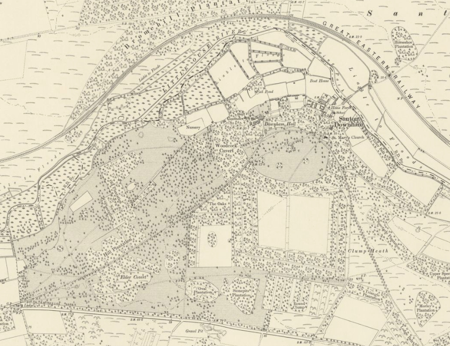
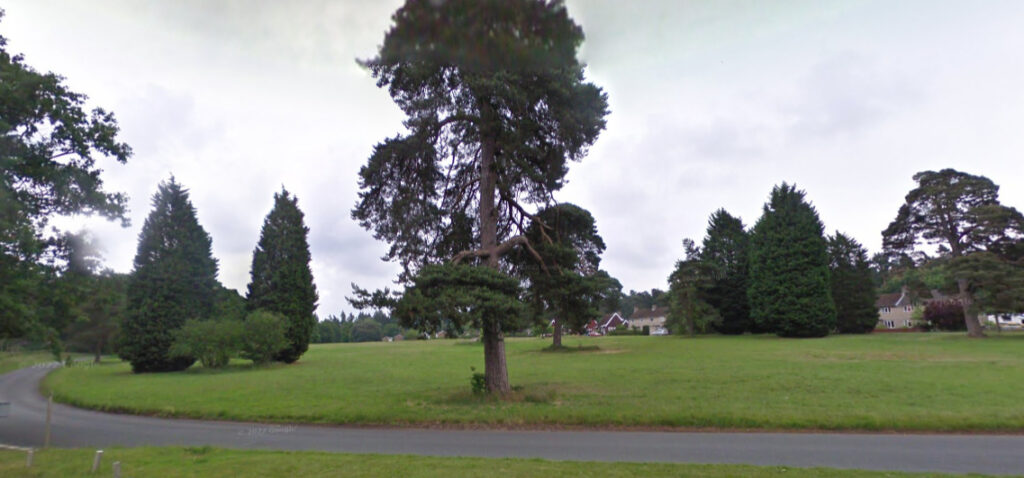
In 1918 the estate was sold to Frederick William Wateridge and over the following years much of the estate was acquired by the Forestry Commission (now Forestry England), who demolished the house in 1925 to make way for their regional headquarters and planted many coniferous trees as part of their afforestation scheme. Over time houses were built on and near the site of Downham Hall, originally for Forestry Commission workers, and later in the twentieth century many more were built surrounded by dense tree plantations. A large village green dotted with a few mature coniferous trees south of the hall site has been created on land that was once part of Downham Hall parkland.
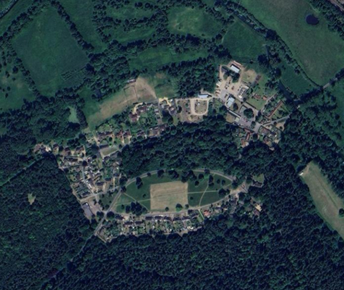

Almost nothing remains of the old house save an icehouse (Grade II) attached to Billiard Room Cottage that is dated to the early- to mid-nineteenth century and archaeological monitoring in 2001 at The Old Coach House identified a large soakaway plus building debris from the buildings associated with Downhall Hall. Underground pits related to the gasometers north-west of the Hall buildings were revealed during excavation of footings at ‘The Gas House’ in 1990 and LiDAR imagery in 2015 identified two circular mounds with hollow centres that have been interpreted as possible garden features or perhaps a World War II military features. Remnants of the walls around the kitchen garden shown on the 1884 OS map appear to have survived.
Downham Hall estate lands are now within the patchwork of pine trees, heathland and broadleaf trees and the Site of Special Scientific Interest (SSSI) of Thetford Forest, which covers 18,730ha (46,283a).
SOURCES:
Copinger, Walter, The Manors of Suffolk, Vol. 4, 1909.
Finch, Canon John, St. Mary the Virgin, Santon Downham, Suffolk, 2007.
Kelly’s Directory of Suffolk, 1892.
Kirby, John, The Suffolk Traveller, 1753.
Roberts, W. M., Lost Suffolk Country Houses of Suffolk, 2010.
Paine, Clive, ‘Downham Lodge’ in Suffolk Institute of Archaeology and History, Excursions, Vol. XXXIX Part 1, 1996.
Wilkie, Gwyneth, ‘Edward Mackenzie’ Lives Retold website https://static1.squarespace.com/static/5c65dd81af46834afd07e40a/t/5f50c488a28d284e9be538f0/1599128736194/lives+retold+mackenzie+edward.pdf (accessed January 2026).
Williamson, Tom, Suffolk’s Gardens & Parks, 2000.
https://www.forestryengland.uk/thetford-forest (accessed January 2026).
https://highlodgeheritage.fotf.org.uk/hhhl/human_heritage/high_lodge_downham_estate.php (accessed January 2026).
https://www.brecsoc.org.uk/projects/warrens-project/warrens/santon-downham/ (accessed January 2026).
https://competitions.landscapeinstitute.org/capability-brown/garden/caversham/index.html (accessed January 2026).
https://en.wikipedia.org/wiki/Charles_Cadogan,_1st_Earl_Cadogan (accessed January 2026).
https://www.santondownham.org/downhamhall.html (accessed January 2026)
https://suffolklandscape.org.uk/landscapes/estate-sandlings/ (accessed January 2026)
https://22villages.manystories.org/santondownham22/downham_hall.htm (accessed January 2026).
Maps:
1783 Hodskinson’s Map of Suffolk in 1783.
1884 (surveyed 1881 to 1882) Ordnance Survey map.
1905 (revised 1903) OS map.
1929 (revised 1926) OS map.
2015 LiDAR image. (Crown Copyright Scottish Government, SEPA, Fugro and Scottish Water 2012–2022)
Heritage Assets:
Suffolk Historic Environment Record (SHER): STN 007, STN 017, STN 025, STN 045, STN 055, STN 057, STN 095, STN 136, STN 147, STN 249.
Church of St Mary (Grade I), Historic England No: 1351353.
Icehouse at Billiard Room Cottage, Hall Drive (Grade II), Historic England No: 1248709.
Suffolk Archives: (formerly Suffolk Record Office):
(SA) NRA 5827 or (SA) 651/37. Santon deeds, Downham Newall Manor memorandum rel to delivery of court rolls to Thetford Priory, 1475–1500.
(SA) NRA 5827 or (SA) 651/36. Santon deeds, Downham Monkshall Manor, estreats, 1607–1622.
(SA) NRA 5827 or (SA) 651/32/10. Santon deeds, Downham Ixwoth Manor, estreats, 1620.
Manor memorandum rel to delivery of court rolls to Thetford Priory, 1475–1500.
(SA) Q/SH/87. Santon Downham and Brandon highways diversion orders, April 1800.
(SA) Q/SH/15. Santon Downham and Brandon highways diversion orders, March 1824.
(SA) FL621/13/1. Album of photographs of the Mackenzie family of Downham Hall, 1865.
Norfolk Record Office:
(NRO) MC 662/22, 793 x 5. Map of the estate of Robert Wright, Santon Downham, 1778.
(NRO) no reference stated. Cadogan family, Earl Cadogan, Santon Downham maps, 1805, 1812.
Site ownership: various private residences and Forestry England
Study written: January 2026
Type of Study: Desktop
Written by: Tina Ranft
Amended:
