(previously known as Upland Grove and The Grove)
Parish: BUNGAY TOWN (previously in Bungay Holy Trinity and Bungay St Mary parishes)
District: EAST SUFFOLK (previously Suffolk Coastal)
TM 333 880
Not open to the public
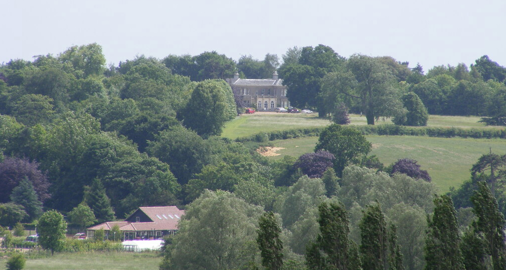
In a rural position on the Suffolk clayland plateau, nineteenth century Upland Hall (Grade II) stands towards the top of the valley escarpment with fine views overlooking the Waveney River, the county boundary between Norfolk and Suffolk. It is just south-west of the outskirts of Bungay and the small Upland Hall Estate once straddled the parish boundaries of Bungay Holy Trinity and Bungay St Mary until they were combined under the umbrella of Bungay Town Council in the twentieth century. The house, gardens and small area of parkland were in Bungay St Mary with the rest of the estate in Bungay Holy Trinity.
In 1819 Robert Butcher Esq. was said to be ‘of Upland Grove’, the name of the property at the time. He was a prosperous wine merchant whose home would have looked towards the Earsham distillery across the county border in Norfolk that he inherited from his father Mark. By 1841 the census lists Robert and his wife Gina Maria, both 75 years old, living with a number of servants at the property, now called ‘The Grove’.
Robert died in 1844, the year of the tithe apportionment for Bungay Holy Trinity parish, by which time the estate was owned by his heirs. Soon after it appears to have been acquired by John Margitson Esq. (sometimes misspelt Margetson) and by the 1848 tithe apportionment for Bungay St Mary it was in the hands of John’s trustee, William Hartcup (1814–1895), a solicitor from Bungay. William had married into the Margitson family of Ditchingham House with his marriage to Louisa Jane Margitson (1818–1898) in 1843.
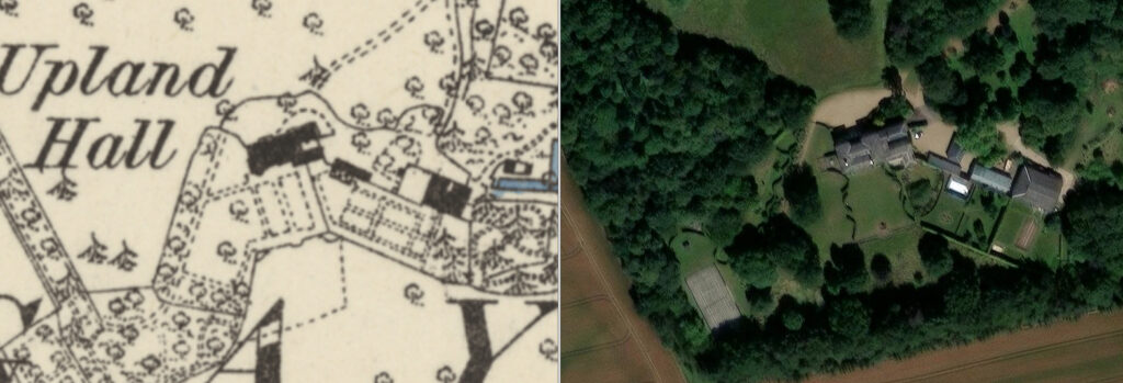
The accompanying tithe maps for Bungay Holy Trinity and Bungay St Mary parishes show the main drive off the Flixton to Bungay road leading up the valley escarpment to the house. At a high point, the rectangular house, with bay to the north, was orientated with the longest side north to south. With views of the valley below, it was surrounded by pleasure gardens with a northern sinuous boundary, possible a ha-ha, with the parkland sloping down towards the river. The southern garden was flanked by an orchard and plantation. A stable yard and ancillary buildings were to the east with a gardener’s cottage attached to a square walled kitchen garden, plus one other cottage and garden beyond. Two subsidiary drives came off the road running south from Bungay to St Margaret Ilketshall and the Elmhams to arrive at these buildings from the east.
Census returns show William Hartcup, Louisa and their family living at the house from 1861 to 1881. During this time it was re-named Upland Hall. However, in 1851 the census has them at ‘The Lodge’ in Ditchingham, which was also owned by the Margitson family.
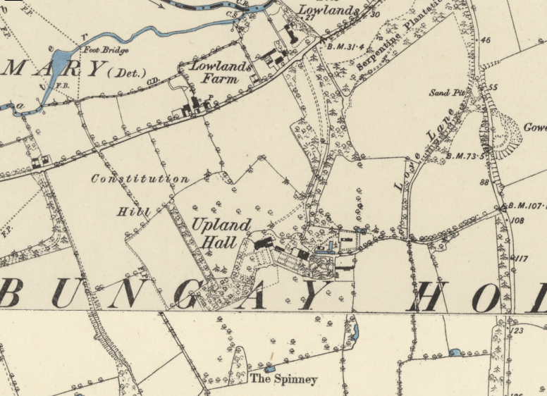
The 1884 OS map shows the present house standing on the same site as that depicted on the tithe map, but the orientation of the house had changed since 1848 with its longest length now approximately east to west, which gave more windows with commanding views of the valley below. This suggests a major rebuild or alterations and additions had taken place, including the addition of an entrance loggia arcade and ancillary wing to the east, possibly around 1851 when William and Louisa were living in Ditchingham, presumably while the building works took place.
On the map parkland stretches out to the south and north with a shelterbelt to the west and a walled formal pleasure garden with curved alcove to the south of the house. From here paths led to wooded pleasure grounds to the south-west. The kitchen garden had been expanded since the tithe map to east and west and was now attached to the walls around the southern pleasure garden. This meant the loss of one cottage to be replaced by a new building on the outside of its northern wall. The garden had perimeter and cross paths with an area to the east taken up by coniferous trees. A lean-to glasshouse had been built against the western end of the north wall. Beyond to the east was a further area with paths weaving through a planting of coniferous trees. A farmhouse and barns with a garden lay to the north-east of Upland Hall.
William Hartcup died in September 1895 aged eighty-two at home at Uplands Hall and Louisa died three years later. At the turn of the century their son, Herbert is recorded as living at Upland Hall.
By 1908 Cecil Sergeant and his wife Mary are resident, although in 1919 the Uplands Hall Estate was for sale. It later changed ownership on a number of occasions, including a short period c. 1960 when it was a school.
It then became the home of merchant banker and former Chairman of Historic England Sir Laurie Magnus and his family. The property was once more for sale in 2020.
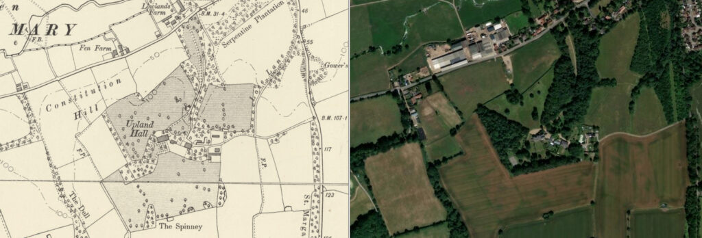
The parkland survived into the twentieth century, although today it is much reduced with a number of fields used for agriculture. The nineteenth century shelterbelts have been extended, creating a splayed view of the river valley from the house. Most of the walls for the enclosures near the house appear to have been replaced by hedges, there are fewer paths and more area is laid to lawn. A new belt of trees, planted since the beginning of the twentieth century, gives privacy to the gardens on their southern boundary and the earlier belt of trees to the west has been extended to form a wood. Additional serpentine hedges flank the southern view and to the west and south-west of the house. The farmhouse is now in separate ownership.
SOURCES:
Scott, John and Taylor, John, The London Magazine Vol. 2, 1820.
The Gentleman’s Magazine, Part II, 1819.
The Law Journal, Vol. 30, 1895.
Tymms, Samuel, The Family Topographer, Vol. 3, 1833.
Walford, Edward, The County Families of the United Kingdom, 1880, 1894.
White, William, History, Gazetteer & Directory of Suffolk, 1844.
Census: 1841, 1851, 1861, 1871, 1881, 1891, 1911.
Maps:
1844 (surveyed 1845) tithe map and apportionment for Bungay Holy Trinity.
1848 (surveyed 1847) tithe map apportionment for Bungay St Mary.
1884 (surveyed 1882) Ordnance Survey map.
1906 (revised 1903) OS map.
1928 (revised 1926) OS map.
1951 (revised 1946) OS map.
Heritage Assets:
Upland Hall (Grade II). Historic England No: 1234764.
Suffolk Archives (previously Suffolk Record Office):
SA) K681/1/75/9. Postcard of Upland Hall, the residence of H. J. Hartcup, c. 1903.
Norfolk Record Office:
MC 14/125, 388 x 7. Sales particulars for Upland Hall Estate, Bungay, 1919.
Site ownership: Private
Study Written: February 2026
Type of Study: Desktop
Written by: Tina Ranft
Amended:
