Parish: ACTON
District Council: BABERGH
TL 891 454
Not open to the public
North of Acton village, the isolated moated site of Acton Hall is surrounded by fields with the Church of All Saints (Grade I) c. 250m to the south. Sudbury is c. 4.8km (3mls) to the south-west and the surrounding landscape is of gently rolling arable fields on the Suffolk clayland plateau.
The de Hodeboville family held the manor in the late-twelfth century and the moat could date to this period. Moats at this time are believed to have been a reflection of status as opposed to having any defensive role. It passed through the de Bures family, to the second Earl of Essex and appears to have become a farmhouse rather than a manor house before the sixteenth century.
By the time of the 1839 tithe apportionment Earl Howe, a member of the Jennens family of nearby Acton Place, owned the manor and tenanted farmhouse. The apportionment map shows a house in the interior of a circular moat with an entrance causeway on the south-west side and farm buildings lying outside the moat on the north side of the approach drive. By 1885 the house had been replaced by one slightly further south but still within the moat, which was now mainly dry with only the south-east segment water-filled. Trees lined the dry moat ditch with further bridging points to the north-west and north-east. An unusual extended-cruciform-shaped complex of farm buildings had developed to the west of the site, with an avenue of trees along the entrance approach, possibly of a much earlier date. An orchard lay south of the moat.
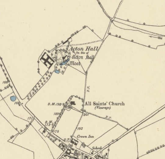
Replacing an earlier house within the moat, a farmhouse built after 1849 is shown on the 1885 OS map. By this time the moat was partially dry and a substantial complex of farm buildings had been built to the west of the moat and an avenue of trees lined the entrance drive.
In 2022 the farmhouse and much of the surrounding land is owned and farmed by the same family. The moated site has changed little since the late-nineteenth century. Field and other boundaries are still as they were at that time, the entrance drive has an avenue of trees that has been recently replanted and the orchard has been grassed over. However, the nineteenth century farm buildings have been replaced and the mid-seventeenth century double-aisled tithe barn from the site coming up for auction in 2014, having been dismantled and stored in the late 1980s.
SOURCES:
Copinger, W. A., The Manors of Suffolk, Vol. 1, 1905.
Cromwell, Thomas. K., Excursions in the county of Suffolk, 1818.
Martin, Edward, Suffolk Gardens Trust talk, 6 February 2025.
http://www.the-saleroom.com/en-gb/auction-catalogues/summers-place-auctions/catalogue-id-srsum10002/lot-a740c522-f6c4-4100-8755-a3f700d80482 (assessed December 2016).
1839 tithe map and apportionment.
1885 Ordnance Survey map.
1905 (revised 1896) OS map.
1928 (revised 1924) OS map.
2022 Google aerial map (Imagery © Bluesky, CNES / Airbus, Getmapping plc, Infoterra Lts & Bluesky, Maxar Technologies, Map data © 2022).
Heritage Assets:
Suffolk Historic Environment Record (SHER): ACT 006.
Church of All Saints (Grade I), Historic England No: 1036718.
Site ownership: Private
Study written: January 2023
Type of Study: Desktop/external visit
Written by: Tina Ranft
Amended: February 2025
