(previously known as Bansfield Hall)
Parish: WICKHAMBROOK
District Council: WEST SUFFOLK (previously St Edmundsbury)
TL 747 570
Not open to the public
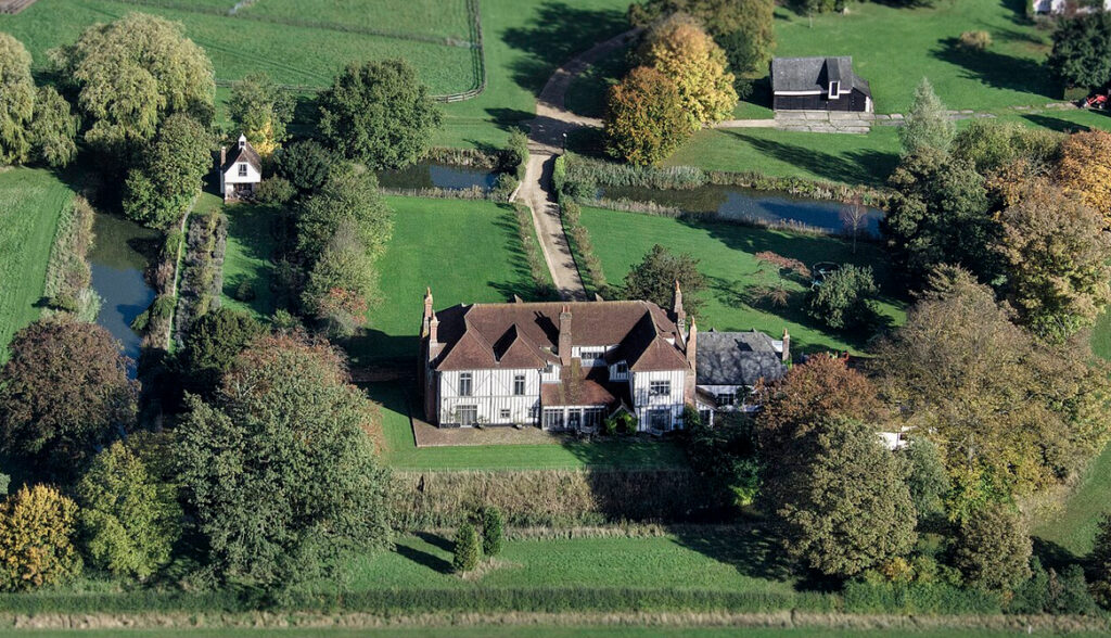
The large parish of Wickhambrook is c. 10 miles south-west of Bury St Edmunds and close to the county boundary with Cambridgeshire. The area is characterized by undulating clay farmland with low hilltops dissected by small streams flowing south. North of the village of Wickhambrook, Badmondisfield Hall (Grade II*) lies close to the north-west boundary of the parish with Ousden parish to the north and Lidgate to the west. It stands within an ancient parkland landscape that developed from wood pasture and two medieval deer parks. The Hall is c. 115m above sea level on high ground to the west of a tributary of the River Glem that flows south to join the River Stour at Long Melford. Ancient woodland feature as isolated blocks and parish settlement is scattered and often occurs near ancient greens, for instance Badmondisfield Hall is adjacent to Genesis Green.
OWNERS OF BADMONDISFIELD HALL ESTATE
Badmondisfield (Bademondesfelda) is recorded in Domesday Book as a substantial royal manor that was granted by Henry I to Baldwin de Boulers. It then passed by descent to the Hastings family until 1389 when the Grey family acquired it. Although they also held the neighbouring manor of Lidgate and its later park known as Cropley Park, Badmondisfield Hall was a favoured residence of the Greys giving an attractive setting in an area particularly significant for its woollen cloth industry in which the family had extensive interests and a suitably grand and impressive residence from which to oversee their East Anglian estates.
The Greys owned Badmondisfield until the early-sixteenth century when Richard Grey, 3rd Earl of Kent was forced to dispose of the manor due to large debts. Charles Somerset, Earl of Worcester, at the time Lord Chamberlain to Henry VIII, was the next owner. The Somerset family are believed to have rebuilt the earlier medieval house on the site.
The Somersets sold the manor c. 1600 to Roger, Lord North or his younger son, Sir Henry North (d. 1620). By 1674 Badmondisfield Hall was a substantial property and is recorded on the hearth taxes with nineteen hearths, a further three at ‘the Lodge’, a reference to a park lodge that lay within the medieval deer park but does not survive.
Not long after the hearth tax returns, the manor was sold to Francis Warner (d. 1684) and the Warner family made it their home for the next century. By 1783 it had passed down the family to Nathaniel Barrett (d. 1789) and was lived in by his widow Sarah until she died in 1796.
With no children to inherit, Badmondisfield was left to Sarah’s nephew Nathaniel Warner Bromley (1756–1844). Recorded on censuses during the second half of the nineteenth century as ‘Bansfield Hall’, the Hall and estate passed down through the family into the twentieth century and is recorded on the 1911 census as Badmondisfield Hall and the home of the widow Henrietta Warner Bromley. Henrietta was in her eighties and lived at the Hall with three daughters and five servants, although three years later she died.
Henrietta’s son Nathanial Barrett Warner Bromley (1869–1936), a solicitor, had inherited his father’s Badmondisfield estate of c. 121ha (300a). In 1916 he is recorded as living at the Hall with his sisters. Over the years he extended his landholding to c. 405ha (1,000a) but overspent on the Suffolk estate and lost money on various agricultural ventures. He was declared bankrupt, followed by three years imprisonment for fraud in 1932 and died five years later.
After Nathaniel’s prison sentence, Frank Joseph Woollard (d. 1947), who is said to have previously eloped with Amelia Bromley (d. 1950) daughter of Nathaniel, bought Badmondisfield Hall and c. 29ha (72a) in 1933. In October 1946 the Badmondisfield estate was advertised for sale by the Woollards. It is not known if it sold but was for sale again when an advert appeared in Country Life in 1959.
There followed a succession of owners over the next forty years, during which time the land attached to the house reduced to c. 20ha (50a) and it was severely damaged in a fire while refurbishment work was taking place.
THE HALL
The timber-framed house was built on a moated site in the fifteenth or early-sixteenth century, probably the rebuilding of an earlier medieval hall house by the Somerset family. Eric Sandon, writing in 1977, believed that traces of this earlier period still remained. It includes a fine surviving fifteenth century great hall with exposed timber-framing and arched braces. Unusually, a chapel was created over the entrance porch to replace the Chapel of St Edwards that once stood on an island within the moat. This is believed to have been pulled down c. 1591 by Sir George Somerset.
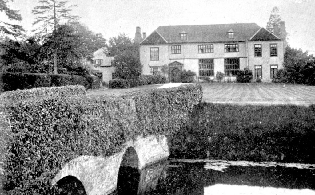
Two centuries later the Warner family Georgianised both the exterior and interior of the Hall. This included removing the top storey to create a two storey plus attic house. Further alterations were made by 1908. After World War II the house was once again altered, which Pevsner in his architectural guide to Suffolk, described as ‘a dramatic mid-twentieth century beauty treatment’, with the roof raised and timber frame exposed.
Today Badmondisfield Hall’s external faces have exposed timber framing with both plaster and brick-nogging infill. It is accessed by a two-arched bridge across the moat.
GARDENS AND DESIGNED PARKLAND
The medieval deer parks of Badmondisfield and Lidgate, known as Cropley Park, once lay to the south and west of the moated Badmondisfield Hall and appear to have been managed as one in the late-fourteenth century. A survey of Badmondisfield manor dated 1391/2 lists the park of Badmondisfield including land in the parish of Lidgate. Following the purchase of the estate by the Somerset family in the early-sixteenth century, a number of references are made to a park at Badmondisfield and a map dated 1598 clearly shows the park extending into Lidgate parish. Further records suggest there may have been two parks, one the old medieval park and a new park established around the rebuilt Badmondisfield Hall to the west and confirmed by a 1598 map. It is likely that the amalgamation of the two parks took place at an earlier date, probably when the Greys held both manors.
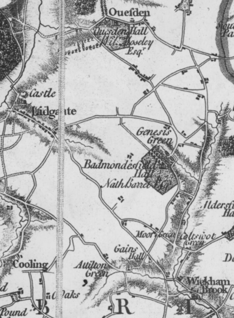
By 1783, when owned by Nathaniel Barrett, Hodskinson’s map depicts the park south of Genesis Green, bounded to the east by the road from Wickhambrook northward through the green and onward to Ousden. To the north-west, off a road between the green and Lidgate, there was a track passing through Spring Wood, which appears to have been included into Badmondisfield parkland. It led to an entrance into the park where it continued flanked by an avenue of trees to the bridge over the moat. There was another entrance on the edge of the park’s northern boundary that had an entrance causeway between two ponds fed from the stream running south-eastward to join the River Glem that must have dramatically marked the change from public to private space.
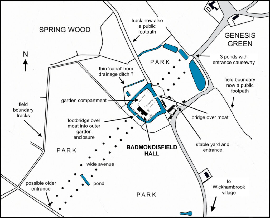
By the time of the tithe map associated with the 1840 tithe apportionment the estate had passed through marriage to Nathaniel Warner Bromley. The earlier avenue of trees shown on Hodskinson’s 1783 map from the north-west appears to have been lost, although its drive is still shown. This avenue had been replaced by a wide avenue of trees on the central axis of the house extending to the north-east and south-west of the moat. North of the moat the avenue crossed an enclosure covering c. 32ha (79a) named ‘Dove House Meadow’, suggesting the existence of a lost dovecote that would have been in existence since the medieval period. On the edge of the enclosure there were three linear ponds at right angles to the avenue. Beside the road from Wickhambrook to Ousden there was a central causeway and entrance into the parkland – creating a clear and dramatic division between public and private space – although no entrance drive in the avenue to the moat is shown on the map and it is unclear if this was a cartographic omission, a drive had never existed or perhaps the drive had disappeared by this time to be replaced by an entrance through the stable yard outside the moat to the east.
The tithe apportionment records the park as covering c. 32ha (79a). There was a small linear pond at right angles to the main avenue of trees some distance south-west of the house and a further thin linear pond immediately outside the moat to the north-west that probably developed from a drainage ditch. This created a garden enclosure between the moat and the linear pond. Another rectangular pond lay along the enclosure’s south-west boundary, although this had gone by 1886.
As today, the large sub-rectangular moat encloses c. 0.85ha (2a) with the main entrance from the north via a two arch bridge that, although once thought to date to the eighteenth century, is now believed to be much earlier with a fifteenth century date. Shown on the tithe map, there was a further small bridge over the moat to the south that accessed a rectangular garden area immediately outside the moat with what appears to be a length of revetment, possibly forming a short ha-ha between the garden and the park beyond. Edward Martin has suggested the moat had its north-west arm straightened to give the appearance of an ornamental canal.
A surviving Georgian summerhouse is shown on the tithe map next to the water inside the moat and within a long narrow compartment, formed by a surviving parallel partition. This configuration is suggestive of a small, formalised garden that was fashionable during the late-seventeenth and eighteenth centuries. Yards and stables were sited outside of the moat with direct access from the adjacent road to the east. This road continued, as today, to curve around ‘Dove House Meadow’ to the entrance causeway.
By 1885 the estate had passed through marriage to the Warner Bromley family. By this time two of the three northern linear ponds had been amalgamated and a new entrance with surviving single storey lodge had been created from the east, a short distance north of the stable entrance. The new east drive curved around a belt of deciduous and coniferous trees which hid the stable yard and associated buildings, arriving in front of moat’s bridge.
Although without a drive, the northern avenue continued to exist as freestanding parkland trees, much like the southern avenue that survived at this time. The 1885 OS map shows a building just to the east of the most southern end of the avenue and marks it as a viewing point. Not only would this have given views across the flat parkland back to towards the moat and house but would also have acted as an eye catcher or focal point from the house.
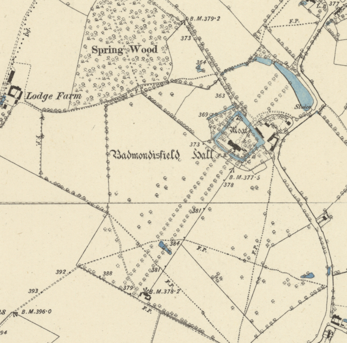
Pleasure gardens are shown on the 1885 OS map as almost surrounding the moat. The area to the west between the thin linear pond and the moat was planted with a mix of deciduous and coniferous specimen trees that also surrounded the stable yard. Paths following the alignment of the moat arms featured both outside to the south-east and within the moat.
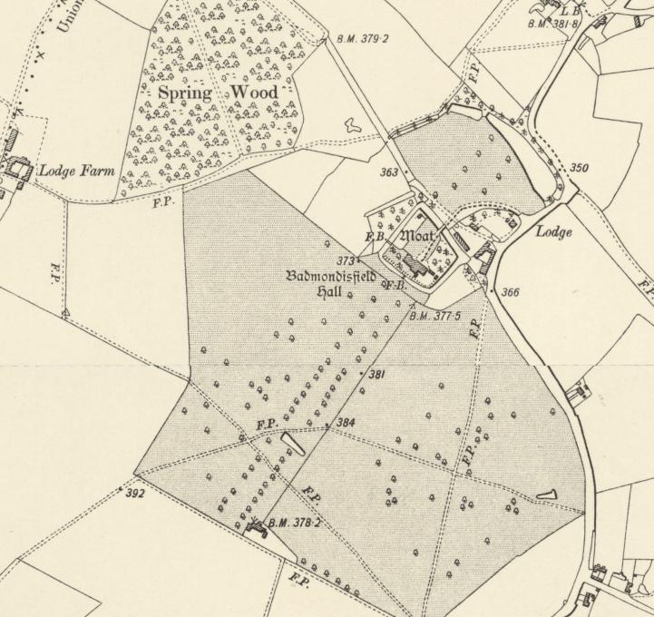
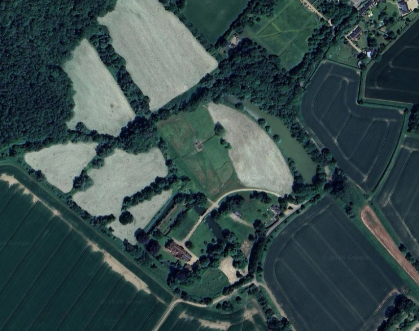
Little changed to the park and gardens into the twentieth century, although by the 1980s the avenue of trees had gone. Today the south parkland has been lost to agriculture, the two linear northern ponds have become one expanse of water and part of the north park appears to have become an outdoor riding area. In addition, a number of trees outside of the moat have been lost and most of the stable buildings have gone to be replaced by a tall hedge along the road boundary. The nineteenth century lodge along the eastern boundary survives and stands at the main entrance towards the moat and house. However, within the moat the summerhouse and linear partition survive, although nineteenth century paths and plantings have been lost or simplified.
SOURCES
Copinger, W. A., Manors of Suffolk, Vol. 5, 1905.
Country Life, vol. C, 1946. From https://www.sleekburnprints.com/1946-country-life-magazine-emilia-echandia-nelson-villa-cheltenham-9852-1778-p.asp, (accessed July 2018).
Country Life, 1959.
Dallas, P., ‘Elite Landscapes in Late Medieval and Early Modern East Anglia’, 2013. UEA Thesis. Unpublished document.
Haverhill Echo, 20 February, 1932.
Hoppitt, Rosemary, Deer Parks of Suffolk 1086–1602, 2000.
Kelly’s Directory of Suffolk, 1922, 1929.
Martin, Edward, ‘Garden Canals in Suffolk’ in East Anglia’s History, Studies in Honour of Norman Scarfe, 2002.
Martin, Edward, Pastime of Pleasure, Suffolk Gardens Trust, 2000.
Pevsner, Nikolaus, The Buildings of England. Suffolk, 1974.
Sandon, Eric, Suffolk Houses. A Study in Domestic Architecture, 1977.
http://www.suffolklandscape.org.uk/landscapes/Undulating-ancient-farmlands.aspx.
https://lynnswaffles.com/2023/08/19/the-holworth-collection-chapter-4-badmondisfield-hall-estate%F0%9F%93%9A/ (accessed June 2026)
http://www.burypastandpresent.org.uk/suffolk-villages/wickhambrook.shtml (accessed October 2023).
http://www.stedmundsburychronicle.co.uk/Chronicle/1946-2000.htm (accessed October 2023)
Census: 1851, 1871, 1881, 1891, 1901, 1911.
Maps:
Hodskinson’s Map of Suffolk in 1783.
1840 (surveyed 1839) tithe map and apportionment.
1884 (surveyed 1884) Ordnance Survey map.
1903(revised 1901) OS map.
1952 (revised 1950) OS map.
2026 Google Imagery © 2026 Airbus, Maxar Technologies, Map data © 2026.
Heritage Assets:
Suffolk Historic Environmental Record (SHER): WKB 005, WKB 011.
Badmondisfield Hall (Grade II*). Historic England No: 1235891.
Suffolk Archives (previously Suffolk Record Office):
(SA) HD2723, papers related to the Barrett, Warner, Bromley and Duckinfield families, 1721–1913.
(SA) SB00281, Sales Particulars of the Estates of Badmondisfield Hall and Aldersfield Hall, Wickenhambrook, 9 October 1946.
Site ownership: Private
Study written: June 2026
Type of Study: Desktop
Written by: Tina Ranft
Amended: