Parish: ASPALL
District Council: MID SUFFOLK
TM 172 653
Not open to the general public
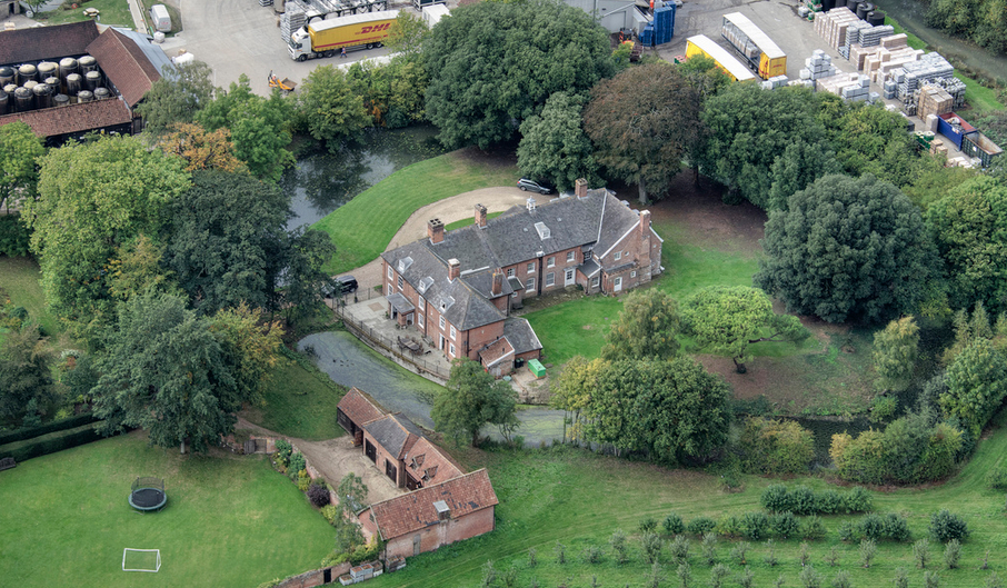
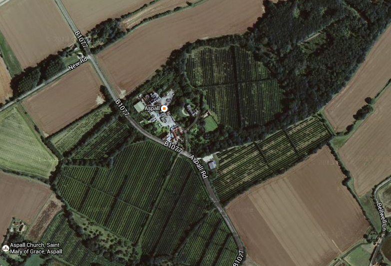
Close to the headwaters of the River Deben, which makes its way south-eastward towards the North Sea, Aspall Hall (Grade II) lies c. 0.5km (0.3mls) north-east of the medieval Church of St Mary of Grace (Grade II), c. 2.6km (1.6mls) north of Debenham and 16km (10mls) north-east of Stowmarket. It is accessed from the B1077 between Debenham and Eye.
One of the smallest parishes in Suffolk and not to be confused with Stonham Aspal, Aspall parish consists scattered isolated farms and a small hamlet centred on the church that lies towards the parish’s southern boundary. Mentioned in Domesday Book as the site of a fair, the parish is believed to have once been more important and much larger, extending southward to the outskirts of Debenham. It was said by W. A. Copinger in his Manors of Suffolk that the manor was formerly known as Harborough Hall cum Aspall, although the exact site of Harborough Hall is unknown. The parish once had a green to the north of Aspall Hall and Aspall Wood is an isolated c. 10.58ha (26a) block of ancient woodland mainly consisting ash, hazel and hornbeam lying just north-east of the site.
OWNERS OF ASPALL HALL
Mentioned in the Domesday Book and owned by Walter Langton, Bishop of Lichfield (d. 1321), the manor was held by William de Hoddeshaugh, followed by the Peverells, and through marriage William de la Pole in the fourteenth century. It is thought to have passed down to Sir Edward Brooke in the fifteenth century and was inherited by Edward Brooke, Lord Cobham in 1482. The Brook(e) family owned Aspall Hall and manor until it was sold to Temple Chevallier in 1702. Thus began the ownership of Aspall Hall Estate by the Chevallier family to the present day.
Temple died in 1722 and it passed to his cousin Clement Benjamin Chevallier (1698–1762) who came from Jersey and brought with him the knowledge of and some equipment for cider making. While waiting for his newly-planted fruit trees to produce a crop, Clement bought fruit from local growers. Son and heir of Clement, the Revd Temple Chevallier (1731–1804) inherited Aspall on his father’s death and it passed to his widow Mary (née Fiske) when he died in 1804. It then passed to her son the Revd Temple Fiske Chevallier (1764–1816) who was rector of Badingham, followed by his younger brother John Chevallier MD (c. 1774–1846), a physician and agriculturalist who became well-known for introducing Chevallier barley, a malting variety that revolutionised the brewing of ale.
John had also been ordained and was the perpetual curate of Aspall from 1817 to 1846 and vicar of Cransford from 1831. Later he opened Aspall Hall to accommodate six mentally ill patients on the first floor. He died in 1846 and Aspall passed to his widow and afterwards the Revd Charles Henry Chevallier (1823–1885), the rector of Aspall and an Honorary Canon of Norwich – a mark of distinction usually given to hard-working parish priests. In 1854 Charles married Isobella Francis Cobbold (1834–1917), the only daughter of the Revd Francis Cobbold of the Ipswich brewery dynasty.
John Barrington Chevallier (1857–1940), the eldest son of the Revd Charles Henry and his wife Isobella, was a successful amateur footballer before taking over the Aspall family business on his father’s death in 1885, becoming a fruit grower, cider maker and also a JP. John was responsible for adding the ‘y’ instead of an ‘i’ in the word ‘cider’, which is said to differentiate Aspall’s cider from West Country varieties.
Perronelle Guild (née Chevallier) took over the running of the business when her father John died in 1940. She became a founder member of the Soil Association resulting in Aspall Cyder becoming an organic producer. In 2018 the multinational brewing company Molson Coors bought the Aspall Cyder operation, although a member of the Chevallier family still lives at the Hall.
ASPALL HALL
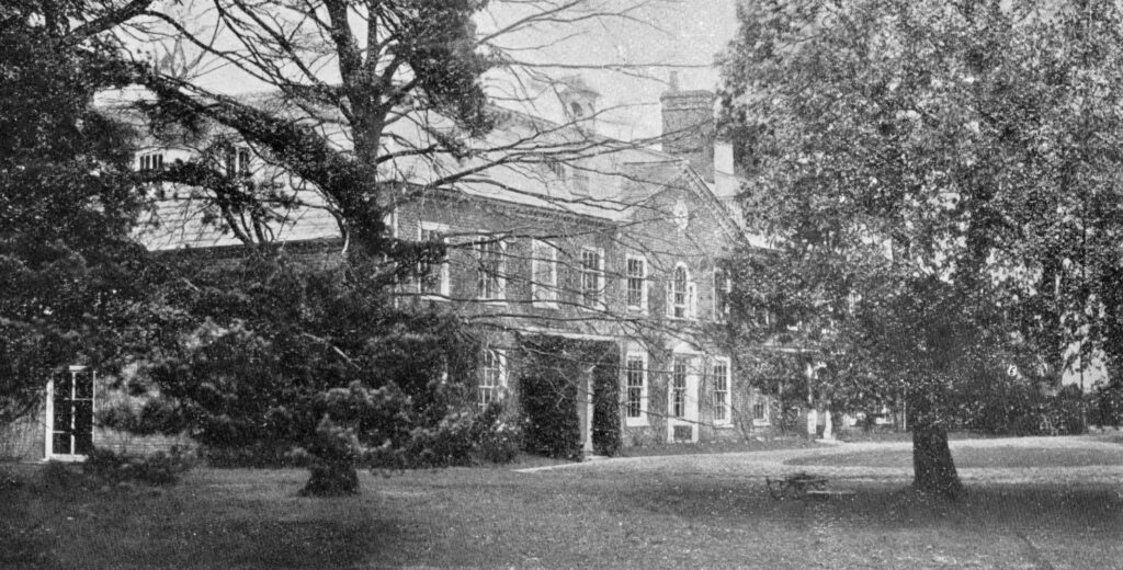
A former manor house, Aspall Hall sits on an island in the middle of an oval moat. The house dates from the late-sixteenth century but was altered over the following centuries. It consists a long twelve bay main range facing south-west and running from north-west to south-east with a rear service wing to the south forming an L-shaped plan, but with a short rear wing at the north end. The wings have early-eighteenth century facades of red brick and the brick gable end of the north wing dates from c. 1600.
It has been suggested by the present owners that Clement Chevallier, who died in 1805, may have been responsible for adding the unusually long red brick front in the latter part of the eighteenth century, which differs from the early-nineteenth century date on the Historic England listing. This elevation has two entrances with porches to the left and right of the shallow central gable with an octagonal sundial that is said to be of a later date. In the centre of the gable there is a window that replaced an earlier doorway. Although c. 1600 trusses survive in the roof, it was largely re-built in the early-nineteenth century. Internally there is a fine late-sixteenth century plaster ceiling in the parlour and early-seventeenth century panelling in north wing.
GARDENS, PARKLAND AND ORCHARDS
The large, oval moat surrounding the island on which Aspall Hall stands is still water-filled and believed to date back to the medieval period. From the house, the land slopes gently down to the water. In 1898 an article in Country Life Illustrated describes trees such as ilexes, copper beech, pines and laburnums planted in the sloping lawns and drooping over the water It also mentions ‘gardens, orchards, flower-beds, herbaceous borders, and the old stew ponds full of bullrushes’ outside of the moat.
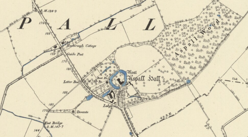
Today the entrance drive flanked by trees bridges the moat over its southern arm with a turning circle in front of the house. The Country Life Illustrated article suggests that the main entrance drive was previously from the west, bridging the western arm of the moat and centred on the house where the central doorway in the shallow gable has been replaced by a window. Such a drive is very likely to have continued westward towards the parish church. It is unclear when the drive was moved to its present position, although the move had taken place by 1838 when the tithe map associated with the 1842 tithe apportionment was surveyed.
The article goes on to suggest the entrance drive was flanked by another moat that had been in-filled. However, it is unclear where this was exactly located, although the ‘canal-like’ pond shown on the 1838 tithe map to the south-west of the moat may be a remaining arm. Alternatively, the writer of the article may have misinterpreted the ‘canal-like’ pond as one remaining arm of a moat when it was a surviving pond of a pair running parallel to the avenue of trees shown on the tithe map. This pond survived into the mid-twentieth century but was lost when additional buildings associated with the cider making process were added.
By 1838 the drive on the moat continued beyond the house to a secondary bridge across the north-east corner of the moat. This gave access into pleasure grounds surrounded by a belt of trees with a bottle-shaped pond leading to a regular planting of trees suggesting an orchard. Historic England’s Research Records state that the northern bridge has been replaced by a concrete dam.
Chevallier land surrounded the moated site and included fields sloping down to the river west of the road leading from Debenham to Eye. These were called ‘First Dove House Meadow’ and ‘Second Dove House Meadow’ and were separated by a thin strip of trees known as ‘Dove House Plantation’ with a circular feature and small central building representing the dove house. This survived into the twentieth century but has since been lost. If the entrance drive had originally been centred on the house it would have passed close to the dovecote on its way to the church and created a dramatic approach to the house from the opposite direction, possibly with a wide avenue of trees that continued the ‘avenue’ between the moat and road shown on the map.
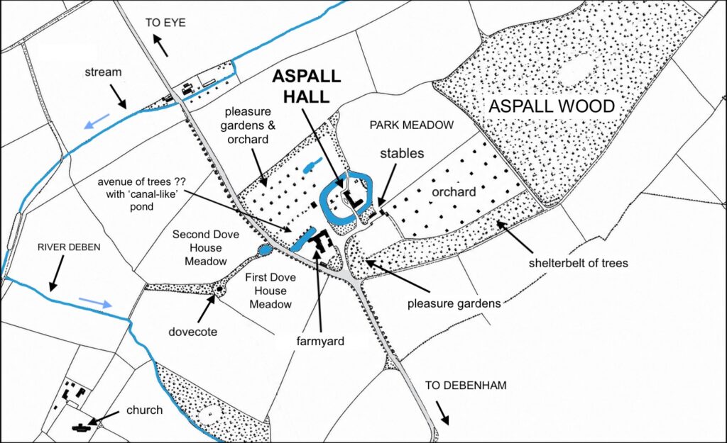
In 1838 parkland lay to the north-east of the moat with the ancient woodland of Aspall Woods beyond. An orchard with southern belt of trees separated the parkland from the fields to the south, with a further orchard to the north-west. Clement Chevallier is described in the Country Life Illustrated article as having planted woods and created a small park ‘in which he reared hares and deer for sale, and sent venison up to London’.
As today, the gardens inside the moat in the early-nineteenth century consisted lawns sloping down to the water and dotted with a variety of trees. Shielding a view of the stables, a mixed planting of trees and shrubs lay outside the southern arm of the moat with pleasure gardens beyond.
Just outside the moat near its south-west corner is the surviving old cyder (cider) house (Grade II) that was created c. 1730 from a former seventeenth century barn. This has a distinctive 1771 wind vane added by Revd Charles Henry Chevallier. Preserved inside is a horse-powered crusher with granite trough and runner stone dated 1728 and a screw press dated the following year, although this was altered in 1922. Nearby a boat house is marked on the outside of the moat on maps from 1838 well into the twentieth century, although it appears not to have survived.
Today orchards surround Aspall Hall and have developed over time as each new member of the Chevallier family planted more trees across the estate. The Country Life Illustrated article describes the orchards as divided by ‘archery lawns, stew ponds, and pleasure grounds’. Today over forty varieties are grown, many dating back to the nineteenth century, plus a number of rare, non-commercial varieties.
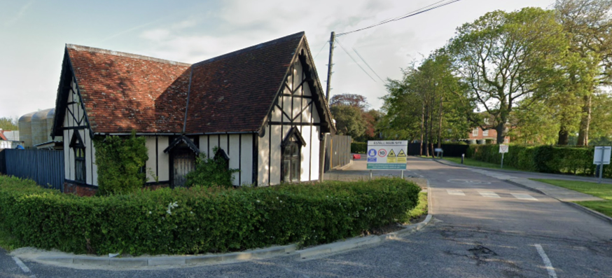
A single-storey cottage orné lodge sits at the southern end of the site where the drive meets the road between Debenham and Eye. It is not shown on the tithe map of 1842 but had been added by 1885, suggesting it was the work of the Revd Charles Henry Chevallier. Just to the north of the lodge is the site of the old farm buildings with a loose three-sided courtyard plan, some surviving and supplemented by modern industrial units where Aspall Cyder and Cyder Vinegar is still produced.
SOURCES
Barker, H. R., West Suffolk Illustrated, 1907.
Copinger, W. A., The Manors of Suffolk, Vol. 3, 1909.
Country Life Illustrated, 12th November 1898.
Chevallier, F. E. M., ‘Extracts from the Chevallier Papers, 1728–1762’, Suffolk Institute of Archaeology and History, Vol XVI, Part 3, 1918.
Doig, Sarah E., The A-Z of Curious Suffolk : Strange Stories of Mysteries, Crimes and Eccentrics, 2016.
Girling, F. A., ‘Early sixteenth century decorated bricks at Aspall Hall’, Suffolk Institute of Archaeology and History, Vol XXIXI Part 3, 1963.
Kelly’s Directory of Suffolk, 1869, 1883.
Pevsner, Nikolaus, The Buildings of England: Suffolk, 1961.
Sandon, Eric, Suffolk Houses. A Study in Domestic Architecture, 1977.
Stephen, Leslie (ed), Dictionary of National Biography, 1887.
Stone, Michael (ed), The Diary of John Longe (1765–1834), vicar of Coddenham. Suffolk Records Society, 2008.
Walford, Edward, The County Families of the United Kingdom, 1860.
White, William, History, Gazetteer, and Directory of Suffolk, 1874.
https://debenham.onesuffolk.net/useful-information/local-history/debenham-the-early-history/ (accessed June 2026)
https://docs.planning.org.uk/20240702/39/SFXVU9SHMYB00/x5uapdufxlno5hj0.pdf
https://grokipedia.com/page/john_chevallier_physician (accessed June 2026).
https://family-tree.cobboldfht.com/biographies/729/john-barley-chevallier (accessed June 2026)
https://family-tree.cobboldfht.com/biographies/207/john-barrington-jb-trapnell-chevallier (accessed June 2026).
https://www.aspall.co.uk/blogs/our-story/family (accessed June 2026). https://family-tree.cobboldfht.com/biographies/207/john-barrington-jb-trapnell-chevallier (accessed June 2026).
http://www.aspall.co.uk/our-story/place/aspall-hall (accessed March 2023).
Maps:
Hodskinson’s Map of Suffolk in 1783.
1842 (surveyed 1838) tithe map and apportionment.
1884 (surveyed 1884) Ordnance Survey map.
1905 (revised 1903) OS map.
1933 (revised 1903) OS map.
2026 Google Imagery © 2026 Airbus, Maxar Technologies, Map data © 2026.
Heritage Assets:
Suffolk Historic Environmental Record (SHER): ASP 001, ASP 005.
Aspall Hall Hall (Grade II). Historic England No: 281282.
Church of St Mary of Grace (Grade II). Historic England No: 1213437.
Old Cyder Press (Grade II). Historic England No: 1032404.
Historic England Research Record Hob Uid: 388773.
Suffolk Archives (previously Suffolk Record Office):
(SA) HD11/475/Aspall/733/4, Map and plan of Aspall Hall, the property of the late Revd Temple Chevallier, 22 May 1809.
Site ownership: Private
Study written: July 2026
Type of Study: Desktop
Written by: Tina Ranft
Amended: