Parish: BARHAM
District Council: MID-SUFFOLK
TM 137 509
Not open to the public except on specific days for charity
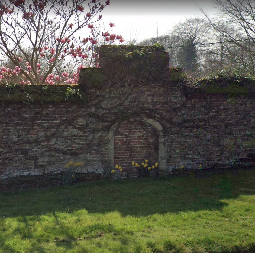
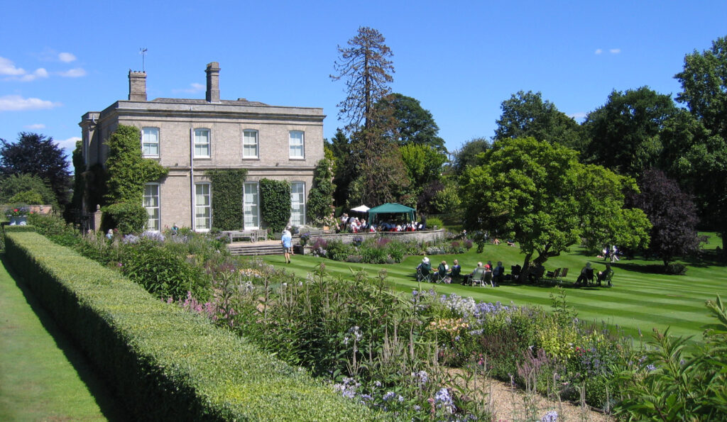
In the south of the parish of Barham and forming a complex with the Church of St Mary’s (Grade I), Barham Hall is c. 9.5km (6mls) north-west of Ipswich in an elevated position on the valley side of a stream as it flows southward to join the River Gipping. The church and Hall are separated by Church Lane running south-west to Claydon and north-east towards Henley. The present unlisted mid-nineteenth century house replaced a Tudor mansion on the site, the remains of which survive as a boundary wall and blocked gateway (Grade II) beside the road. The present gardens of Barham Hall occupy the Tudor mansion site straddling the steep valley with a small area of parkland on rising ground to the south.
OWNERS
The original Barham Hall was the residence of the Southwell family from the mid-fifteenth century, a wealthy and influential family who may have acquired it after the Dissolution from the priory of Ely. Subsequently the Hall and estate became the property of the Wood family, then Robert Burch (d. 1725) and by the beginning of the nineteenth century John Medows Rodwell, Esq. who was thought to have been one of the most skilful and informed agriculturists in Suffolk.
By 1844 the manor and Hall were owned by Joseph Burch Smyth, Esq. (d. 1852) of Stoke Hall, Ipswich, who was probably responsible for demolishing the original Tudor mansion at the end of the nineteenth century when a descendant of Smyth, Henry P. Phillips, took up residence with his family. After the death of Henry Phillips in 1920 Barham Hall and estate were bought by Sir Anthony Compton-Thornhill, Bt., and in 1967 it was sold once more.
BARHAM HALL
The present mid-nineteenth century house replaced the Southwell’s moated mansion on the site. The Southwell’s coat of arms surmounts a surviving early- to mid-sixteenth century blocked pedestrian gateway, which is opposite a path leading to the church. It is within a length of a flanking wall that is believed to have been an entrance and enclosing wall to the base court of the Southwell house. The mansion was replaced by the present mid-nineteenth century country house comprising a single rectangular range with service wing attached to the north-east elevation. The coach house/stables and offices were further to the north-east with access directly off the road. The current owners have made further additions to the house and the coach house/stables have been altered and repurposed.
GARDENS AND PARKLAND
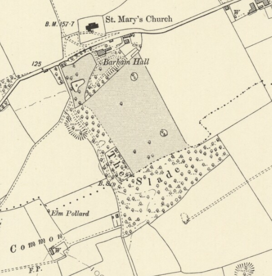
Although marked on both Kirby’s 1736 and Hodskinson’s 1783 maps, the first known detail of the site comes from the tithe map of 1844 (surveyed 1840). It shows it to be near the head of the steep-sided valley, with the present house built on the valley’s north side. The main gardens followed the dry valley contours down to the south-west where spring water collected into two oblong ponds that were joined by a narrow watercourse to form an L-shaped feature. An area of woodland was nearby. The small area of parkland was shown with freestanding trees and turned southward in a strip that included a chalk pit, with a path running through it from the road to woodland called The Slade and onward southward towards Claydon parish church.
Little changed over the next forty years, although the 1884 Ordnance Survey map gives more detail of the pleasure gardens. The house is shown standing on a platform with a level garden terrace to the south and west. From here a path ran south-westward beside the road boundary to a gateway and another path led to the terraced steep-sided escarpment on the opposite side of the valley. Serving as an entrance lodge, one of the buildings around the coach house/stables stood beside the entrance drive that passed the kitchen garden and curved towards the house. By this time the ponds had developed into one single L-shaped pond. A field south of the escarpment had become part of the parkland by 1905. Fifteen years later sales particulars described the Barham Hall Estate as a mansion with stabling, glasshouses, grounds and 32ha (80a) of land in Barham and Claydon.
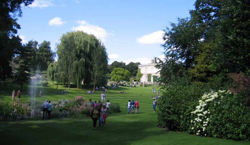
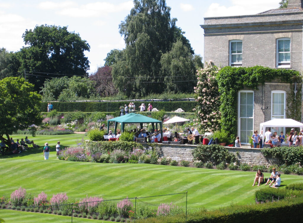
The general layout of the garden changed little during the twentieth century. Today a fountain and arcadian statue in a stone niche are focal points to the pond and appear to have been twentieth century additions. Along the steep-sided escarpment opposite the house there is a rose arbour walk dissected by a grand flight of stone steps that was constructed in the 1960s. The arbour leads to an area of mature shrubs and trees towards the south-west before joining the narrow strip of once-wooded land – the portion of the historically named ‘The Slade’ – that climbs steeply up to the south. During the late-twentieth century this area was cleared to create a swathe of lawn bordered by mature trees with views to the pond below. The bridleway called ‘The Slade’ is now outside the gardens. West of the house and parallel to the road is a long rill along a narrow terrace on the valley side. This appears to be a late-twentieth century formalisation of a more naturalistic path shown on the 1884 OS map. The earlier terracing around the house survives and beyond is a terraced lawn with borders and a tennis court. To the north-east there is an enclosed area of lawn and borders that was once the Victorian kitchen garden, with an adjacent lean-to glasshouse attached to a building that once formed part of the stable yard.
SOURCES:
Country Life, Sales advertisement, July 6, 1967.
Kelly’s Directory of Cambridgeshire, Norfolk and Suffolk, 1922.
Kirby, William and Spence, William, An Introduction to Entomology: Or Elements of the Natural History …, Vol. 1, 1818.
Loudon, John, Claudius, An Encyclopaedia of Agriculture, 1839.
Page, Augustine, Topographical and Genealogical, The County of Suffolk, A Supplement to the Suffolk Traveller (of J. Kirby), compiled 1811 and published in 1844 by Page, Joshua.
Pevsner, N., The Buildings of England, Suffolk, 1961.
The Dictionary of National Biography, Vol. XVIII.
V&A Collections, stained glass heraldic medallion dated 1514–50. (http://collections.vam.ac.uk/item/O333700/panel-unknown/ accessed December 2022).
White, William, History, Gazetteer and Dictionary of Suffolk, 1855.
Who’s Who in Hampshire, 1935.
Census 1861, 1911.
NOTE: In conversation with the owner in July 2017 it was suggested that the monks of Ely Cathedral may have had a priory on the site before the arrival of the Southwell family. Collaborative evidence in M. J. Franklin and Christopher Harper-Bill, eds, Medieval Ecclesiastical Studies in Honour of Dorothy M. Owen (7) (Studies in the History of Medieval Religion), 1995. However, some documentary evidence shows confusion with the well-documented Priory at Barham Hall in Linton, Cambridgeshire.
1736 John Kirby’s Suffolk Map.
1783 Hodskinson’s Map of Suffolk.
1844 (surveyed 1840) tithe map and apportionment.
1884 Ordnance Survey map (surveyed 1881 to 1883).
1905 (revised 1902) Ordnance Survey map.
1928 (revised 1925) OS map.
2022 Google aerial map (Imagery © Bluesky, CNES / Airbus, Getmapping plc, Infoterra Lts & Bluesky, Maxar Technologies, Map data © 2022).
Suffolk Record Office:
SRO (Ipswich), HG400/2/375/2/13. Sales Particulars, 1920.
SRO (Ipswich), HG400/2/375/2. Alterations to Barham Hall for Sir Anthony Thornhill, 1921.
SRO (Ipswich), HE402/1/1949/32. Catalogue of antique furniture at Barham Hall, 1949.
Heritage Assets:
Church of St Marys (Grade I), Historic England No: 1033288.
St Marys Church, Historic England Research Records No: 388732.
Garden Wall and Gateway (Grade II), Historic England No: 1033289.
Site ownership: Private
Study written: December 2022
Type of Study: Desktop and site visit in 2017
Written by: Tina Ranft
Amended: April 2025
