(formerly Kedington Rectory)
Parish: KEDINGTON
District Council: WEST SUFFOLK (formerly St Edmundsbury)
TL 708 464
Not open to the public
Situated in the far south-west of the county c. 4.8km (3mls) north-east of Haverhill and close to the River Stour – the boundary between Suffolk and Essex – Ketton House (Grade II*) was formerly the rectory for Kedington (also known as Ketton). It lies c. 0.8km (0.5mls) south-east of the Church of St Peter and Paul (Grade I) on the edge of this once dispersed village. The powerful and influential Barnardiston family owned the manor of Kedington from before 1578 when Queen Elizabeth I paid a visit to their home at Kedington Hall. They were prominent Puritans and leaders of the Parliamentarians in Suffolk during the English Civil War and held the manor until the mid-eighteenth century when the family line died out with their manor house finally demolished in 1785.
Kedington Rectory was built in the early-eighteenth century, probably at a time when Sir Robert Barnardiston 4th Bart held the manor and made the hall his home after his father’s death in 1700, staying until his own death in 1728. However the name of the rector at this time is not known. With the characteristics of a symmetrical red brick Queen Anne house, it has tall sash windows and matching north and south elevations and was described by Eric Sandon as one of a number of ‘ambitious parsonage houses’ built in Suffolk at this time. When it was originally built the grounds were separated from the main village centre by fields and it is unclear if the site was that of the original rectory – they were often closer to the parish church – although it has been suggested that the present site has ancient origins, suggesting the new rectory may be on the former rectory site.
The Syer family held the living of Kedington from 1760 to 1910. Unusually for a rectory and indicating its status, the house is marked on Hodskinson’s 1783 map of Suffolk. The Revd Barrington Blomfield Syer (1755–1844) became rector in 1800 and was also patron of the living. He married Elizabeth Maria Chevallier, daughter of the Revd Temple Chevallier of Aspall. During Barrington’s time as rector the road between Little Wratting and Baythorne End was diverted further south in 1833, suggesting a desire to make improvements to the gardens of the rectory by allowing more space around the house for gardens and shelterbelts of trees that gave it privacy from the road.
The 1841 tithe map indicates the result of the highways diversion. With a large area of glebe land surrounding the site, the rectory is shown standing in a small L-shaped park and gardens. To the north of the house was a ‘lawn’ – another name for parkland – dotted with freestanding trees with shelterbelts to the north and west and small wood known as ‘Glebe Plantation’ at its south-east corner. The main drive was, as it remains today, from the north through a belt of trees to arrive at the north front of the house. This drive continued to the east and around the house before turning southward and flanked by an orchard to the east to encircle a lawn and pleasure gardens. It continued towards the stable block (Grade II) and large eighteenth century barn (Grade II) where there was a further entrance. It then turned northwards to join the northern entrance drive. Although with no distinction made between paths and drives on the map, what appears to be a path cuts through part of the orchard and another forms a crescent through the western shelterbelt immediately west of the house with a gate to the road. Outside of the park and gardens further south and on the opposite side of the road was a brick and flint walled kitchen garden with cherry orchard beyond.
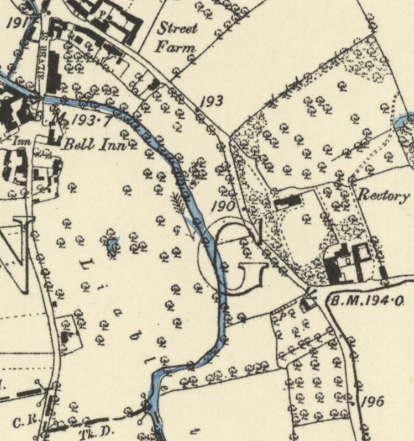
Few changes were made to the house, gardens and park over the following forty years. What appears to be the addition of more trees shattered around the park to the north of the house are shown on the 1885 OS map with a softening of the edges of the south lawn by the addition of shrubberies and the replacement of the crescent-shaped pathway west of the house with a single direct route to the road.
Map evidence suggests there were no further changes to the gardens and park until it became a private house in 1963 when it was renamed Ketton House. The second half of the century saw housing built on the fields immediately north of its grounds and a portion of the southern garden was allocated as gardens for the stable block and barn which were converted for residential use and now in separate ownership. This period also saw the walled kitchen garden become the garden of another residential property with the walls surviving today.
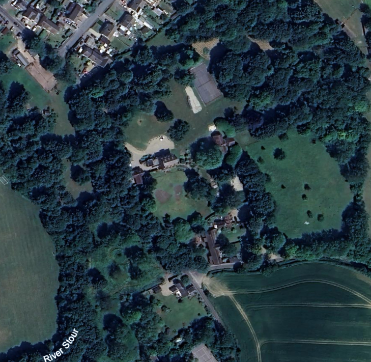
By 2010 the park-like lawn had been converted to pleasure grounds surrounding a tennis court to create in total c. 4.8ha (12a) of gardens. There was an area of mature mixed woodland, some trees dating back to the nineteenth century and including what was believed to be a three-hundred year old mulberry near the main drive. By this time more flower beds had been added north of the house and beside the tennis court. The gardens south of the house included a curved terrace with raised beds, formal lawn and ornamental hedging. An unusual well with a path leading to it flanked by raised beds survives near the house. This has been suggested as an ancient holy well that was sited beside the original road before it was diverted, although there is little evidence to confirm this. A large building, presumed to be an additional residential property built after the 1960s, stands east of the house with an access drive off the road to the south of the site.
SOURCES:
Biographical History of Gonville and Caius College, Cambridge, Vol. II.
Birch, Mel, Suffolk’s Ancient Sites Historic Places, 2004.
Copinger, W. A., The Manors of Suffolk; Notes on their History and Devolution, Vol. 7, 1910.
Editor’s note in Davy, David, Elisha, A Journal of Excursions through the County of Suffolk 1823–1844, Blatchy, John, (ed) Suffolk Records Society, 1982.
Kelly’s Directory of Suffolk, 1853, 1883, 1892, 1921.
Kirby, J., The Suffolk Traveller, 1735.
Muskett, Joseph, James, (ed) Suffolk Manorial Families, Being the County Visitations and Other Pedigrees Vol. 2, 1900.
Sandon, Eric, Suffolk Houses: A Study of Domestic Architecture, 1977.
Suffolk Institute of Archaeology and History, 1865 008. Kedington alias Ketton, and the Barnardiston Family.
Suffolk Institute of Archaeology and History, Proceedings Vol. IX Part 1, Excursions 1895.
Walford, Edward, The County Families of the United Kingdom…, 1864, 1871, 1880, 1894.
White, William, History, Gazetteer, and Directory of Suffolk, 1844, 1855, 1874.
St Edmundsbury Chronicle http://www.stedmundsburychronicle.co.uk/Chronicle/Havto1899.htm (accessed October 2019).
Cobbold Family History Trust https://family-tree.cobboldfht.com/4676, (accessed January 2025)
Open Gardens 2010, The Garden of Ketton House, http://www.kedingtonnews.co.uk/news/1-100/n72-8.shtml (accessed October 2019).
Holy and Healing Wells, https://insearchofholywellsandhealingsprings.wordpress.com/2020/02/19/a-little-known-suffolk-holy-well-the-holy-well-of-kedington/ (accessed January 2025).
Census: 1841, 1851, 1861, 1881, 1891, 1901, 1911.
Maps:
Hodskinson’s Map of Suffolk in 1783.
1841 tithe map and apportionment.
1885 (surveyed 1885) Ordnance Survey map.
1899 (revised 1896) OS map.
1924 (revised 1919) OS map.
1949 (revised 1938) OS map.
1951 (revised 1946 to 1949) OS map.
Google Earth image, Map data © 2023.
Heritage Assets:
Suffolk Historic Environment Record (SHER): KDG 001, KDG 074.
Ketton House (Grade II*), Historic England No: 1031633.
Church of St Peter and St Paul (Grade I), Historic England No: 1376724.
Stable to Ketton House (Grade II), Historic England English No: 1182457.
Barn to Ketton House (Grade II), Historic England No: 1031634.
Suffolk Record Office:
SRO (Ipswich) EE2/Z/3. Appointment by Rev. Thomas Preston, Great Waldingfield, rector of Wratting Parva, of Rev. Dey Syer, rector of Kedington, as his attorney…, 16 July 1761.
SRO (Bury) BA500/F/6/2/58. West Suffolk Quarter Sessions Highway Diversion, January 1833.
Site ownership: Private
Study written: January 2025
Type of Study: Desktop
Written by: Tina Ranft
Amended:
