(previously St Edmund’s Hill and The Mount)
Town: Bury St Edmunds
District: WEST SUFFOLK (previously St Edmundsbury)
TL 869 644
House not open to the public
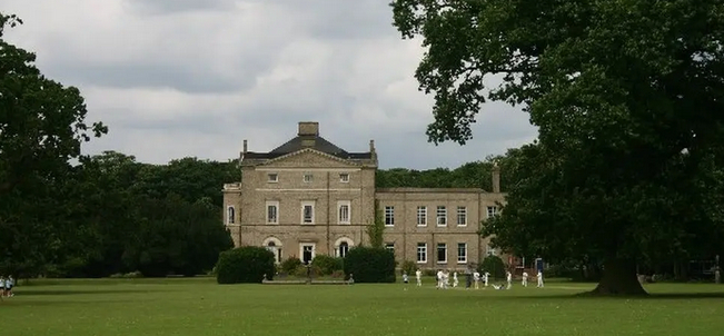
Standing on the brow of the hill to the east of Bury St Edmunds, late-eighteenth century Moreton Hall (Grade II*) once had uninterrupted views down to the abbey’s vineyards, Bury St Edmunds Abbey and the water meadows of the River Lark and River Linnet that join near the abbey site. The site of Moreton Hall was historically in the parish of St James in Bury St Edmunds, one of two parishes in the town, the other being St Mary. In the late-nineteenth century the two parishes were combined to become Bury St Edmunds parish and in 1974 they became part of the new Borough of St Edmundsbury. In 1914 the parish church of St James was elevated to become St Edmundsbury Cathedral.
Originally known as ‘St Edmund’s Hill’, the present country house was built in the 1770s and changed its name to ‘The Mount’ and then to Moreton Hall in the late-nineteenth century.
In 1846 the Ipswich and Bury Railway, later to become the Great Eastern Main Line, was completed running parallel to the river and interrupting the view from the house towards the abbey site.
Until the 1970s the main road route between Ipswich and Cambridge was known as the A45, a winding mostly single carriageway through villages and towns such as Bury St Edmunds. However, in 1973 the Bury St Edmunds bypass was officially opened, its route to the east of the town and separating the Moreton Hall site from Bury’s centre. The road was renamed the A14 in the 1990s to reflect its importance as a major trunk road between the port of Felixstowe and the Midlands.
The land to the east of Moreton Hall was originally the estate’s agricultural fields and heathland but during the 1980s and 90s it was sold off and a large housing development began to develop, which today continues to grow.
OWNERS OF MORETON HALL
It is unclear if there was a house was on the site in the first half of the eighteenth century. In 1773 John Symonds (1730–1807) had the present Moreton Hall built, at the time known as ‘St Edmund’s Hill’. John was the eldest son of the Revd D. John Symonds rector of Horningsheath on the south-west side of Bury St Edmunds, today known as Horringer. His mother was Merilina Jermyn whose family owned nearby Rushbrooke Estate.
John was a Regius Professor of Modern History at Cambridge and became Recorder of Bury St Edmunds in 1768. It is believed he inherited the Moreton Hall Estate from his maternal grandmother, also Merilina Jermyn. An academic and author with an interest in the new scientific approach to agriculture of the time, John contributed to Arthur Young’s Annals of Agriculture during the late-eighteenth century. He has been described as a ‘kindly’ man who was ‘friends to many leading artists, thinkers and scientists of his day’.
John died unmarried in 1807 and was buried in Pakenham, home of the Spring family, Baronets of Pakenham and relatives of his mother. He gave directions that his books be donated to the Historical Library of Cambridge, now the Seeley Library, and is regarded as its founder.
Soon after John’s death the St Edmunds Hill Estate was sold to Thomas Cocksedge (1748–1833), appearing to have been bought for his son Col. Martin Thomas Cocksedge (1781–1824) on his marriage to Mary Susanna Leheup (1787–1858). The Oakes Diaries tell us that the Leheups were ‘a Huguenot family at the centre of Bury society’ and were related, not only to the Symonds, Cocksedges and Godbolds but also the Cullums of Hardwick Hall. They were wealthy landowners in Suffolk, Norfolk, Hertfordshire and the Midlands.
Martin and Mary made St Edmund’s Hill their home and had five children between 1813 and 1824. Martin died in 1824 and the following year Mary married Capt. Charles Stubbs Tinling. The couple had moved to the fashionable resort of Worthing in Sussex by 1828. Surplus to requirements, St Edmunds Hill was rented out, first to Henry Franklyn Esq. between 1826 and 1828.
In 1833 a rental notice appeared in the Bury and Suffolk Herald, 24 April 1833. By this time the house was called ‘The Mount’ although the site with c. 24ha (60a) was still referred to as St Edmund’s Hill. It was described as having ‘luxuriant lawns, pleasure grounds, and plantations which surround the Mansion’. Included were the sporting rights over c. 405ha (1,000a) in the manor. There is no known documentary evidence regarding who became its resident.
It is believed when Martin Cocksedge and Mary’s eldest son Thomas Martin Cocksedge (1813–46) came of age he took possession of St Edmund’s Hill, although it is unknown if he took up residence. After an expensive divorce from his ‘barmaid’ wife, some badly-judged investments and a life of drinking and womanising, Thomas was declared bankrupt in 1845 and was forced to sell the St Edmund’s Hill Estate. He joined his mother in Worthing but the following year he was badly burnt in a fire in his bedroom and died of his injuries.
St Edmund’s Hill was bought by John Josselyn (1781–1884), a wealthy landowner, where he and his wife plus family of eight children lived for the next forty years until John’s death. It is believed he added the new east wing to accommodate his large family.
Around this time the name of the house was changed to ‘The Mount’ and in 1890 the estate was bought by Ferdinand John Eyre (1856–1928), the son of Vincent Eyre of Lindley Hall near Leicester. Ferdinand married Mary Gabrielle Constance Helen Paston-Bedingfield, the daughter of Sir Henry Paston-Bedingfield 6th Bart of Oxborough Hall in Norfolk. Ferdinand, who became mayor of Bury St Edmunds and High Sheriff of Suffolk, changed the name of the house once more from ‘The Mount’ to Moreton Hall. With no children to inherit, when Ferdinand died in 1928 the house and Moreton Hall Estate of c. 456ha (1,128a) was put on market.
In 1932 it was bought by Percy Ridley Thompson (1860–1955) who lived at Moreton Hall with his second wife Alice Bower (1874–1951). They stayed until 1947 when it was sold, becoming a preparatory school with c. 12ha (30a) of parkland. It is unclear if the estate was broken-up at this time.
The Moreton Hall Trust, which is believed to still own the property, acquired the freehold to house and parkland in 2009, although the school continued to exist until 2020 when due to the Covid 19 pandemic it closed, leaving the house unused and derelict in 2025.
THE HALL
Known as St Edmund’s Hill, the country house was designed by the well-known neoclassical architect Robert Adam (1728–92) as a three-storey cube with parapet and cornice for John Symonds. In John’s diary he writes that the foundation stone was laid in 1773 and it is believed the house was completed in 1776. Robert Adam also designed The Theatre and Market Hall (later Town Hall) in Bury St Edmunds, although St Edmund’s Hill is believed to be his only domestic project in Suffolk.
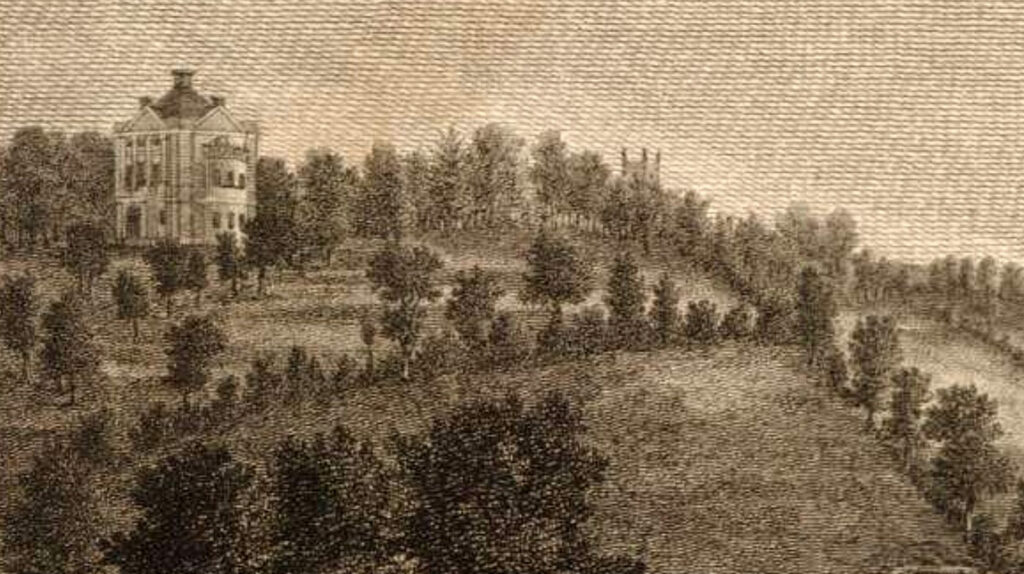
Of white brick with slate roof the house has classic Georgian sash windows. The west and east elevations had large bows with three window ranges running through two-storeys. The entrance front with its porch faced north, as it does today. Soon after it was built, Warren’s 1791 map shows the stables, service block and offices were in separate wings to the east.
Believed to have been for John Josselyn (1781–1884), a two-storey east wing was added in the mid-nineteenth century when the east bow was lost. Internally this wing contains a stair and rooms with heavy woodwork in Jacobean style.
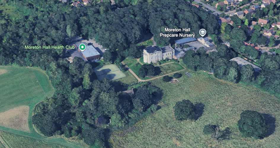
Some buildings on the site to the east of the house were either converted from the existing stable block or added during the period the site was a school. Today a pre-prep nursery exists in one of these buildings.
A number of Adam’s internal features survive such as ceilings, doors and ornamental pelmets, although the building itself is now on Historic England’s Heritage At Risk Register and said to be in a very bad condition and at immediate risk of rapid deterioration, this exacerbated by having suffered multiple incidents of vandalism and fires during 2025.
PARKLAND AND GARDENS
There is no house marked on the Moreton Hall site on Kirby’s 1736 map, but by the time of Hodskinson’s 1783 map John Symonds’ house is shown south of the road from Bury St Edmunds, now known as Mount Road, that passes through Blackthorn Heath as it makes its way eastward to Thurston. The parkland is shown dotted with clumps of trees although with no other detail.
Thomas Warren’s 1791 survey map of Bury St Edmunds is more detailed marking the [slightly elongated] cube-shaped house within an area of parkland to the north, south and west. The entrance is shown to the north flanked by belts of trees before opening up to give views westward over parkland and Bury St Edmunds beyond. The eastern belt marks the boundary with agricultural fields. The stable yard is shown immediately east of the house with a walled kitchen garden on the eastern boundary. A further belt south-east of the house hides the stable yard and a walled garden from the southern parkland area.
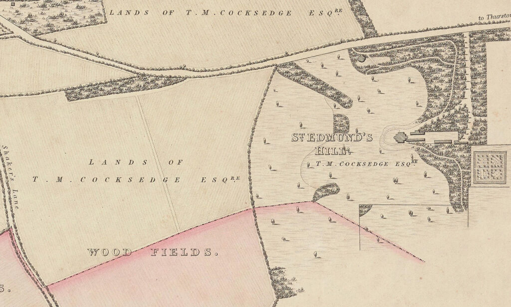
R. Payne’s 1834 plan of the borough of Bury St Edmunds is more precise and detailed, showing the St Edmund’s Hill’s north drive flanked by the belts of trees, the eastern belt wider than it was shown on Warren’s map and dividing near the house, as it does today. One fork goes to the north entrance front of the house before encircling the house and turning eastward through another belt of trees towards the square walled garden with its perimeter and cross paths. The house appears to have an oval-shaped garden enclosure surrounding it and had views across the parkland but no detail as to garden planting in this area. By the time of the tithe map in 1845 a drive turning circle had been developed to the north of the house.
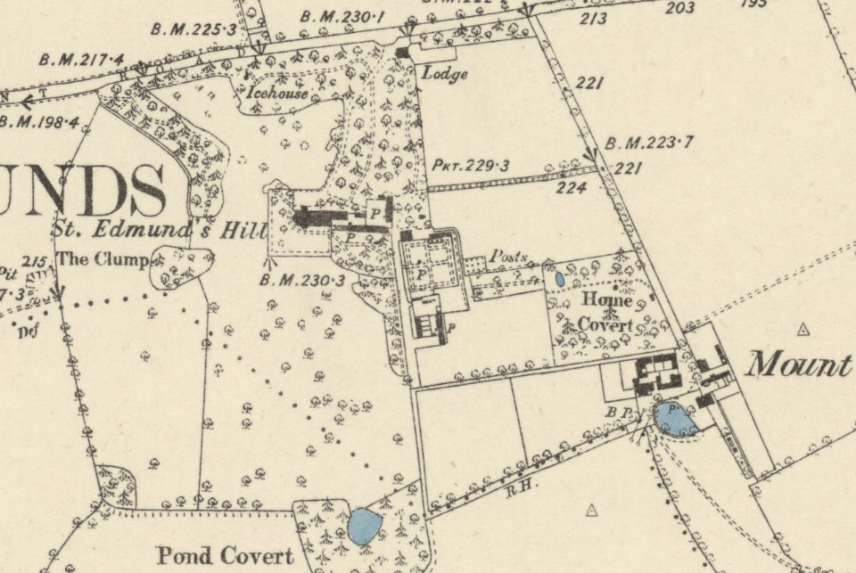
Off the main drive Payne’s map shows a path or track leading back northward through the trees to a clearing and round pond, where an icehouse probably existed, although it is not named until later nineteenth century maps. Another fork heads directly southward to the east end of the stable yard and the walled garden. Dotted with individual trees, the parkland included what is known today as ‘Ten Acre Field’, and is broken up by an elongated wood north-east of the house plus a couple of other smaller woods. Not depicted on the map but believed to be of an early-nineteenth century date is a surviving northern entrance lodge (Grade II).
The survey of the Moreton Hall site, when it was still known as St Edmund’s Hill, for the 1885 OS map took place in 1882, at the time still the family home of John Josselyn who died two years later. The northern belt of trees now continued further along the boundary with the road to fully enclose the northern area of parkland. To accommodate the slope of the site, by this time a square raised terrace had developed to the north, south and west of the house. Within it was lawn dotted with a few deciduous trees but retaining the views across parkland. A path led eastward into a belt of deciduous and coniferous trees, and probably some shrubs, with paths leading to the walled garden and south towards the parkland.
Possibly taken soon after the Eyres bought the estate in 1890, a number of photographs in the Spanton Jarman collection held by Bury Past & Present Society depict the house with a meeting of the hunt on the parkland just south of the house. Flights of steps from the raised terrace down to parkland are shown on the south and west side of the house with a square entrance porch to the north and a lean-to conservatory attached to the south front. By this time specimen conifers had been planted within the raised terrace area and the shelterbelts of trees had matured to create a dense backdrop around the house.
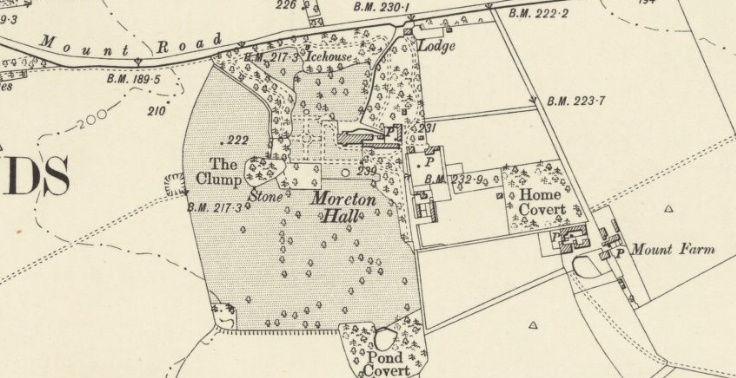
The 1905 OS map shows an expansion of the raised terrace around the house and the western belt of trees extended southward to act as a backdrop to a formal garden with side and cross paths and central feature, which is documented as a rose garden. It appears these changes were made by the Eyre family. To the south of the house a round pond is marked on the map that is shown in a photograph in Suffolk Archives as having a fountain to add visual interest.
During the period the site was a school a number of buildings were either converted from the existing stable block or added. East of Moreton Hall a new residential estate began to be built on Moreton Hall farmland in the 1980s and 1990s that continues to grow eastward.
More recently Moreton Hall Health Club has been built within the tree belt to the north-west of the house and a day nursery has taken up residence in part of the old stable yard buildings. Housing development has continued to expand taking up part of the eastern tree belt of the site with properties nearest to the house butting up to brick walls that are what remain of the original walled garden. A community hall with library and post office has been built to the south-east of the house. At tree-covered cycle path leads from the community hall and passes the south elevation of house. The area of eighteenth century parkland, today known as Ten Acre Field, survives south of the house as do a number of veteran field boundary trees.
SOURCES:
Allen, Chris and Aldam, Angela, ‘Scandal and Riot in Early Victorian Worthing: The Case of Francis vs Tinling’. https://www.academia.edu/17747912/The_1850_Scandal_and_Riot_in_Worthing_Sussex_UK (accessed April 2026).
Bury Free Press, 9 May 1947. ‘Land deal for Moreton Hall school’.
Cambridge University Press Archive, 23 October 2017. Endowments of the University of Cambridge.
Cary, John, Cary’s New Itinerary; or, an Accurate Delineation of the Great Roads … 1828.
East Anglian Daily Times, 22 April 2020. ‘Prep school to close for good after coronavirus ‘unravels plans for growth’.
Evening Star, 18 November 1897.
Fiske, Jane (ed), The Oakes Diaries. Business, Politics and the Family in Bury St Edmunds 1778–1827, 1990.
Kelly’s Directory of Suffolk, 1892.
Kelly’s Handbook to the Titled, Landed and Official Classes, 1895, 1918.
Lee, Sidney (ed.) ‘Symonds, John (1729–1807)’ in Dictionary of National Biography, Vol. 55, 1898.
Pevsner, Nicholas, The Buildings of England: Suffolk, 1974.
Sandon, Eric, Suffolk Houses. A Study of Domestic Architecture, 1977.
Suffolk Institute of Archaeology and History, Vol. XXXIX, Part 3, 1999. Address given by Dr Fiske at the 150th Anniversary Dinner of SIAH.
Walford, Edward, The County Families of the United Kingdom…, 1896.
Young, Arthur, Annals of Agriculture, published between 1784 and 1815.
collections.soane.org/SCHEME788. Sir John Soane’s Museum Collection Online, St Edmund’s Hill (later The Mount, and now Moreton Hall), Bury St Edmunds, Suffolk: executed designs for a villa for Professor John Symonds, 1773–76. (accessed October 2021).
https://stpetersbse.uk/Groups/278095/Our_History.aspx (accessed May 2026).
https://en.wikipedia.org/wiki/Bury_St_Edmunds#History (accessed May 2026).
https://web.archive.org/web/20120426195800/http://www.moretonhallprep.org/default.aspx?pid=11&sid=40. (accessed May 2026)
https://www.suffolk.police.uk/news/suffolk/news/news/2025/july/police–fire-issue-urge-troublemakers-to-steer-clear-of-bury-building/ (accessed May 2026).
http://www.stedmundsburychronicle.co.uk/warren1791/topmid.jpg (accessed May 2026).
https://www.burypastandpresent.org.uk/
https://www.thesloelife.com/post/supreme-in-state-the-oak-tree-and-the-hall
Yale Library, Beinecke Rare Book and Manuscript Library Plan of the borough of Bury St Edmunds in the county of Suffolk https://collections.library.yale.edu/catalog/15259806 (accessed May 2026).
Census: 1851, 1861, 1871, 1881, 1911.
Maps:
1783 Hodskinson’s Map of Suffolk in 1783.
1791 Warren’s map of Bury St Edmunds.
1834 R. Payne’s plan of the borough of Bury St Edmunds.
1845 tithe map and apportionment.
1885 (surveyed 1882 to 1884) Ordnance Survey map.
1905 (revised 1903) OS map.
1947 (revised 1938) OS map.
1953 (revised 1950) OS map.
Heritage Assets:
Suffolk Historic Environment Record (SHER): SHER No: BSE 082.
Moreton Hall School (Grade II*), Historic England No: 1022597.
Lodge to Moreton Hall School, Historic England No: 1022598.
https://historicengland.org.uk/listing/heritage-at-risk/search-register/list-entry/48672 (accessed May 2026).
Suffolk Archives (previously Suffolk Record Office):
(SA) HE 500/3/3. St Edmund’s Hill estate sales particulars, 1884.
(SA) K511/956. St Edmund’s Hill Mansion (now Moreton Hall) south front coloured drawing, undated.
(SA) K511/1152. Photograph album, c. 1900.
(SA) K511/1162. Photograph album.
(SA) HD 1750/121. Sales particulars for Moreton Hall Estate, 26 September 1928.
(SA) HG 500/1/541b. Conversion of outbuildings into school classrooms etc., Moreton Hall, June 1947.
Site ownership: Private
Study written: May 2026
Type of Study: Desktop
Written by: Tina Ranft
Amended:
