Parish: BUXHALL
District: MID SUFFOLK
TL 996 566
Not open to the public
Surrounded by arable fields and remote from the village, Fasbourn Hall (Grade II) is c. 1km (0.6ml) south of the mainly mid-fourteen century Church of St Mary (Grade I) and c. 6.5km (4mls) south-west of Stowmarket. A tributary of the River Gipping runs beside the site.
Originally a large manor house known as Copinger Hall, it was the home of the Copinger family from the fifteenth century. The family were so well-known for their wealth and hospitality that ‘to live like the Copingers’ became a local expression. In 1692 the house and estate were sold to Sir Edward Ward (d. 1714) of London and Stoke Doyle, Northants. It is unclear who were the owners during the eighteenth century but by 1809 it had become a tenanted farm and in 1847 Augustine Page in his A Topographical and Genealogical History of the County of Suffolk wrote that the Fasbourn Hall estate was owned by Richard Hillhouse of Finsbury Place in London.
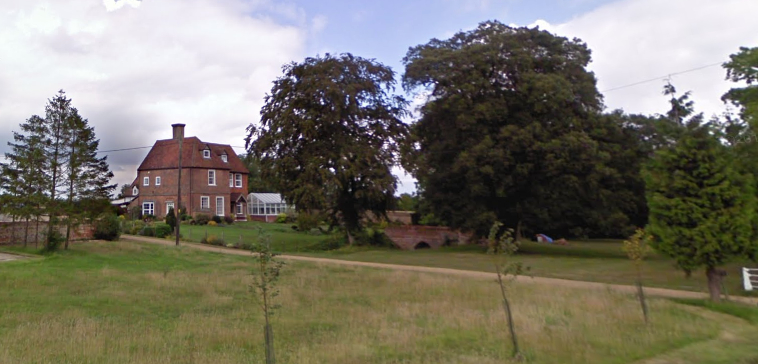
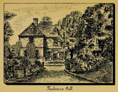
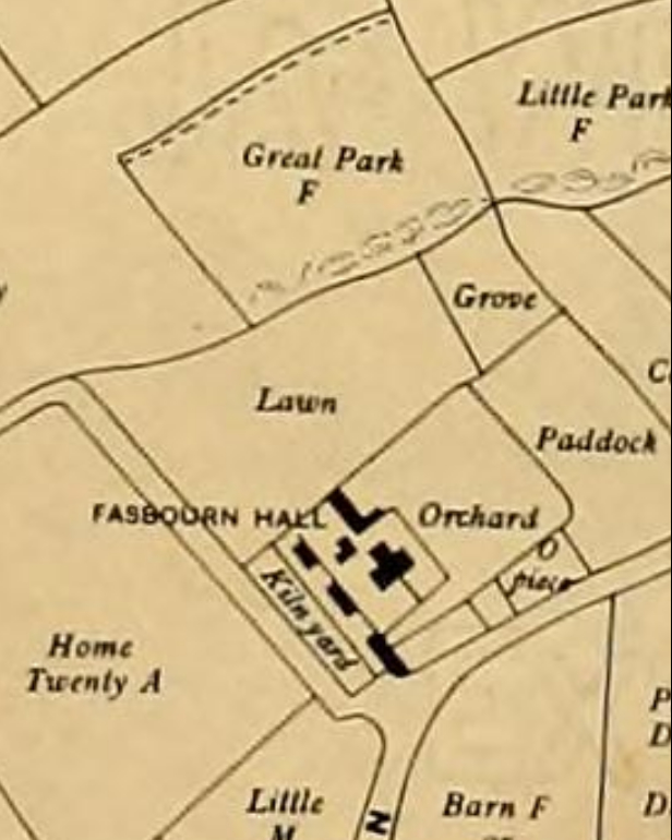
The red brick house is early-seventeenth century, but possibly with an earlier core, that was substantially altered in the nineteenth century. The main section of the current house was originally a cross-wing to a much larger moated property, still of some importance in 1783 and named on Hodskinson’s map of Suffolk. Included in the listing of the house is a section of seventeenth or eighteenth century red brick garden wall about 2m (6.5ft) high. With moulded terracotta copings and a sawtooth course beneath, it extends c. 20m (65.5ft) south-east from the east corner of the house, and is the remains of outside walled enclosures that would have been an integral part of the original house. Attached to both house and wall is a late-nineteenth century glasshouse.
The tithe map that was surveyed in 1841 to accompany the 1837 tithe apportionment shows farm buildings to the south-west of the house. Two surviving arms of the moat approximately parallel are shown on either side of the house and flanking an orchard to the north-east. Both arms were water-filled at this time with the southern arm divided by a causeway and bridged by the surviving seventeenth century double-arched bridge (Grade II). This was once the main entrance approach to the house and may have its origins in the medieval period. Its parapets are capped by terracotta copings that match those found on the garden wall. This southern arm of the moat balloons out into an almost circular pond at its north end. A further pond is shown west of the house.
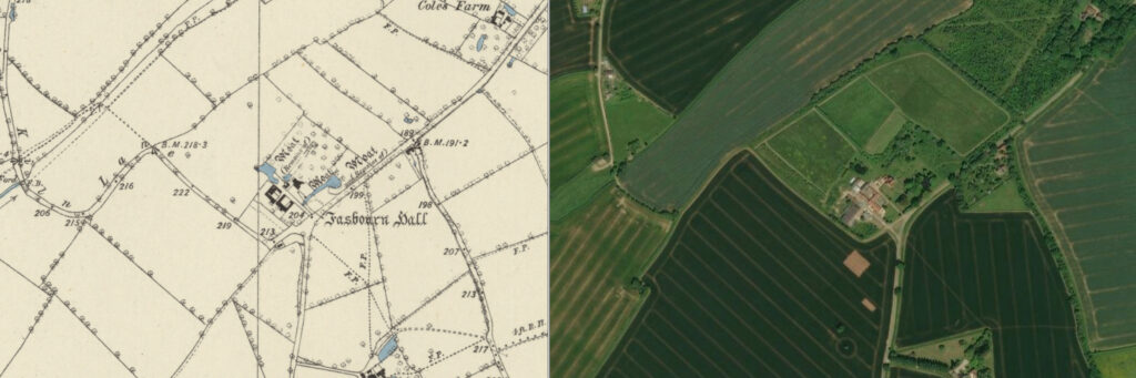
By 1884 the moat’s northern arm was mostly dry and the OS map of that year shows a surviving viewing mound close to its northern end. It is c. 16m (52.5ft) in diameter and 3.5m (11.5ft) high. The tithe apportionment lists a field to the west as ‘Great Park Field’ and so it seems likely the mound originally acted as a viewing mount giving views over an area of deer park. Once Fasbourne Hall became a farmhouse, the mound evolved into a garden feature giving views over the garden and the two arms of the moat that had developed into ornamental gardens ponds or ‘canals’.
In 1902 the Fasbourn Hall farming estate extended to 76.5ha (189a). However, by the beginning of the twenty-first century the estate had been broken-up and 2019 sales particulars list Fasbourn Hall with just c. 10ha (25a) of land, including c. 1.62ha (4a) of established formal and informal gardens and a number of barns and yards that were once farm buildings. By this time Fasbourn Hall was an established bed and breakfast business and glamping site. By 2025 bookings for the bed and breakfast were no longer available.
SOURCES:
Copinger, W. A., History of the Parish of Buxhall in the County of Suffolk, 1902.
Jackson Stops Sales Particulars for Fasbourn Hall, 2019.
Martin, Edward, ‘Garden Canals in Suffolk’ in East Anglia’s History: Studies in Honour of Norman Scarfe, 2002.
Page, Augustine, A Topographical and Genealogical History of the County of Suffolk, 1847.
White, William, History, Gazetteer & Directory of Suffolk, 1844.
http://copinger.org/Intro4.html (accessed March 2026).
Census: 1841, 1891.
Maps:
1783 Hodskinson’s Map of Suffolk in 1783.
1837 (surveyed 1841) tithe map and apportionment.
1884 (surveyed 1884) Ordnance Survey map.
1905 (revised 1902 to 1903) OS map.
Heritage Assets:
Suffolk Historic Environment Record (SHER): BUX 003.
Fasbourn Hall with attached Garden Wall at the eastern Corner (Grade II). Historic England No: 1352168.
Church of St Mary (Grade I). Historic England No: 1352168.
Bridge 30 metres south-east of Fasbourn Hall (Grade I). Historic England No: 1032995.
Suffolk Archives (previously Suffolk Record Office):
(SA) FB218/A/2/1. Map of Copinger Estate in Buxhall, 1763.
Site ownership: Private
Study written: March 2026
Type of Study: Desktop
Written by: Tina Ranft
Amended:
