(and Stow Hall)
Parish: STOWLANGTOFT, LANGHAM, HUNSTON
District: MID SUFFOLK
TL 962 689
Not open to the general public
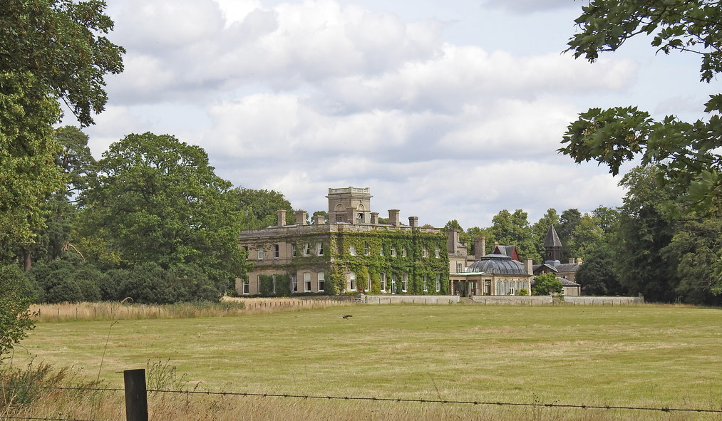
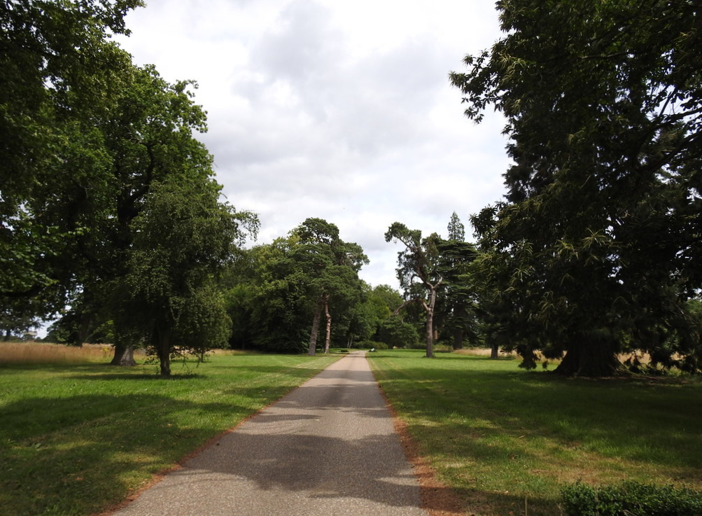
Standing on high ground that slopes gently to the south with views across the parkland, the present Stowlangtoft Hall (Grade II) replaced a much earlier manor house called ‘Stow Hall.’ The village was originally known simply as Stow but took the name of Stowlangtoft sometime during the fifteenth or sixteenth century. The earlier Stow Hall once stood to the south of the present Stowlangtoft Hall, beside a tributary of the Black Bourne river running approximately east to west and forming a shallow valley. This site also includes a surviving walled garden (Grade II). Stowlangtoft is c. 10.5km (6.5mls) north-east of Bury St Edmunds and lie on the central clayland plateau of Suffolk. Stowlangtoft Hall parkland extends into the neighbouring parishes of Langham and Hunston.
OWNERS AND OCCUPIERS OF STOW HALL AND STOWLANGTOFT HALL
Stow Hall was owned by the Ashfield family from the mid-fourteenth century until 1614 when it was sold to Paul D’Ewes, passing down the family to became the home of Sir Simond D’Ewes (1602–50), one of the most distinguished antiquarians of his time. In his autobiography Sir Simon described it as ‘the capital message and site of the manor, called Stow Hall, is a goodly and pleasant seat, which my father, after he bought it, enlarged and beautified very much with brick walls and buildings.’
After legal wrangling, in 1726/27 the estate passed to Thomas Norton. Thomas died in 1756 and in 1760 it was bought by Sir Thomas Rawlinson Knt. (d. 1769), a merchant and Lord Mayor of London in 1754. Sir Thomas lived at Stow Hall with his wife, his first cousin Dorothea, daughter of Revd Richard Ray of Haughley, Suffolk.
It is shown on Hodskinson’s map of 1783 when owned by a merchant banker and MP, Sir Walter Rawlinson Knt., who had inherited it from his father Sir Thomas in 1769. On Walter’s death in 1805 it passed to his nephew Sir George Wombwell Esq., who sold in 1825 to Joseph Wilson (1766–1851), a wealthy London silk merchant, for the sum of £90,000.
Subsequently, Joseph appears to have retired to live at the Stow Hall leaving his son, Henry Wilson Esq. (1797–1866), occupying much of the park and estate that his father still owned. However the 1841 census lists Henry and his family living at the old hall, possibly with his father who was not in Stowlangtoft on census night, perhaps visiting his estate at Little Massingham in Norfolk or staying in his house ‘Highbury Hill’ in North London.
Henry became a JP and MP for West Suffolk and inherited the substantial Stowlangtoft Estate on the death of his father Joseph in 1851. In 1859 Henry had the new Stowlangtoft Hall built on higher ground north of the river and old hall site.
Henry’s son Fuller Maitland Wilson (1825–75) inherited both the Stowlangtoft Hall and Langham Hall estates on his father’s death and was a JP and Lt Col. of the West Suffolk Militia. The estates passed to his son, Arthur Maitland Wilson (1857–1934). Arthur, as a young man, is recorded on the 1881 census as having chosen Stowlangtoft as his home, where he lived with his equally young wife Maude and a number of servants. However, before the end of the decade Stowlangtoft Hall, park and the shooting rights over 2,428ha (6,000a) were to let. During the early 1900s the Jameson family of Irish whiskey fame rented Stowlangtoft.
In 1911 the c. 2,450ha (6,054a) estate was put up for sale and appears to have been bought by Lady Amherst of Hackney and her husband Lord William Cecil, Gentleman Usher to King Edward VII and later to King George, who enjoyed the ‘first-class’ sporting opportunities and are documented as still at Stowlangtoft in 1922, having returned to the hall after the military had used it as a World War I hospital.
The estate was rented by A. J. Edwards in the 1930s and purchased by the family in the late 1940s. During World War II it was let out to London County Council as an evacuation centre for mothers and babies and later as a children’s home.
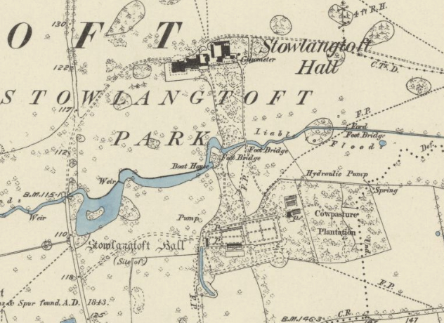
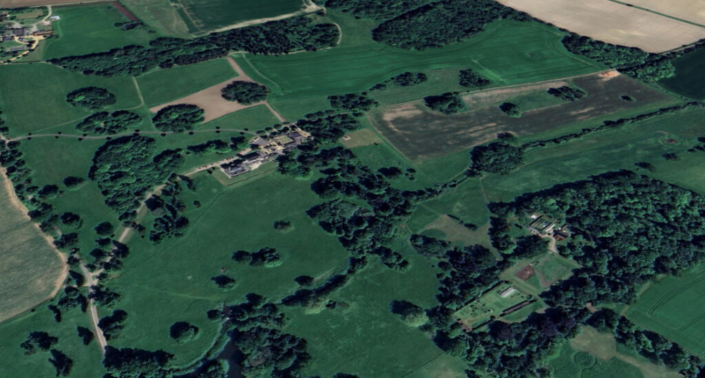
It became a nursing home in 1969, since when the Stowlangtoft Hall Estate has stayed in the same family, descending to the Catchpoles who own and manage the care home today as part of the Stow Healthcare Group and also the wider c. 406ha (1,000a) estate. However, the site of the old hall and walled garden is now in separate ownership.
STOW HALL (‘OLD HALL’), PARK AND GARDEN
Today’s Stowlangtoft Hall replaced the older manor house originally called Stow Hall that once stood on relatively low ground just south of the river, itself a replacement for an earlier manor house. The site has a history dating back to the medieval period with a number of powerful and influential residents such as the Ashfields and D’Ewes, suggesting the house and associated park were of some status during that period.
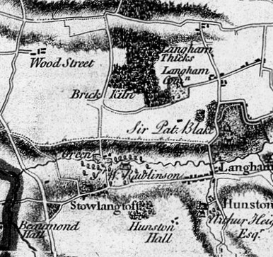
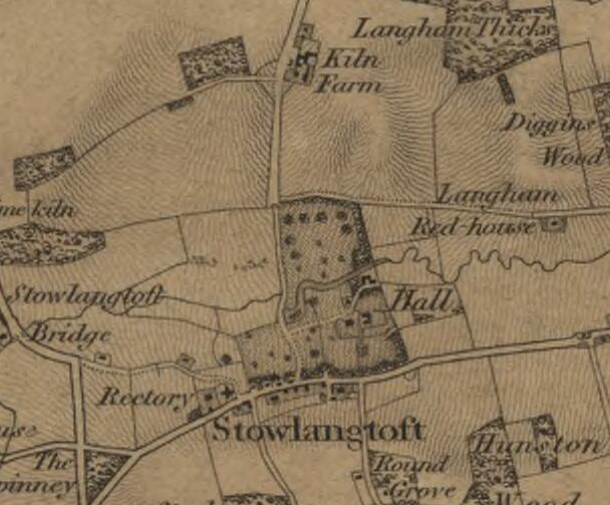
In 1625 there was an agreement between Paul D’Ewes, the owner of the estate at the time, and the bricklayer George Peche regarding building Stow Hall. It is documented that the clay for the bricks was dug on the estate and fired into bricks, presumably at the site of today’s Kiln Farm to the north. Sir Walter Rawlinson Knt., who had inherited the estate is documented as making great ‘additional improvements’ to the house in 1783, the year the ‘Hall’ is shown on Hodskinson’s map on the south side of the meandering tributary of the Black Bourne river, just north of Stowlangtoft village, with a sizeable village green to the west. An east to west road from Langham Hall is shown north of the river and the area surrounding the house and north of the river is dotted with trees, although the detailing of the map does not indicate a formal landscape park.
A map of the estate by R. Payne was produced in 1818 for Sir George Wombwell, which shows a small park covering c. 16ha (40a) with a thin belt of trees around its perimeter and dotted with clumps of trees. The house is marked with gardens to the south-east. By this time the meandering river had been widened to create a long sinuous lake with a likely weir and possible ford. Between the house and water there was an enclosure with a building suggestive of the stable courtyard.
Presumably in preparation for the sale of Stowlangtoft, an estate map by J. G. Lenny dated c. 1824 shows an enlarged irregularly-shaped park of c. 60ha (148a) developed by Sir George. His house was accessed from the west with a drive leading to a turning circle in front of its northern elevation. Here it divided southward to the rear of the house and northward to an enclosure with a building backed by a copse of trees, the likely stable yard. A walled kitchen garden is shown east of the house with a further enclosure beyond. Obviously for drainage purposes, long, thin watercourses are shown in the form of a cross and incorporated as ornamental features into the southern pleasure gardens. The western side of the gardens was made up of a lawned area dotted with random-sized clumps of trees, with the eastern side a more formal layout of flower beds edging paths. Further east were blocks of planting, suggestive of an extension to fruit and vegetable production. Between the house and widened river the building shown on the 1818 map in an enclosure continued to survive.
The 1837 OS map shows Joseph Wilson’s hall with a small park extending northward to the east to west road from Langham that passed ‘Red House’. This road ran further west to join the road out of the village travelling north, which had moved further west and is now known as Kiln Lane. This allowed the development of a sinuous lake with island from the river. The shading indicates an L-shaped landscape park dotted with trees which continued beyond Kiln Lane taking in a field and part of the green shown on Hodskinson’s earlier map.
A year later a highways diversion order was issued relating to Joseph’s estate. This was mainly concerned with stopping public access to the road from Langham Hall that passed the Red House and led westward to the road leading northward from Stowlangtoft village and then continuing further west to the Norton to Ixworth road, now the A1088.
By the time of the 1848 tithe apportionment the parkland directly associated with Stow Hall appears to have reduced in size to c. 35ha (86a), with much of the wider estate occupied by Joseph’s son Henry. However, Joseph continued to occupy many of the plantations on the estate, presumably to pursue his passion for shooting for which the estate was renowned.
The accompanying tithe map is more detailed than Lenny’s c. 1824 map and shows a shelterbelt of trees to the east and south along the boundary with the road through the village enclosing the parkland closest to the house. The square Stow Hall had two attached east wings forming a U-shaped house. Immediately east were service buildings and beyond a trapezoid-shaped walled garden where the east wall is longer than its opposite west side. The west drive off Kiln Lane was partly flanked by an avenue of trees and had views over the sinuous lake and island that appear to have been enlarged since 1824. The drive arrived at a turning circle to the north of the house. As on Lenny’s map, it divided either southward to the rear of the house or northward to the likely stable courtyard. From here a track flanked by an avenue of trees led northward to a copse of trees and bridge crossing the widened river to give access to the north park. In the copse was a building beside the water, probably a boathouse.
By 1848 the pleasure gardens were to the west, south and south-east of the house. The west and southern areas consisted of lawn dotted with trees with views across the parkland and a small ‘canal-like’ pond. A survival from the water features shown on Lenny’s map, a long thin watercourse running north to south divided the pleasure gardens in two and was bridged close to the house. The gardens east of the water had developed with a more ‘natural’ feel utilising a mixed planting of trees and shrubs that hid the orchard and walled garden. A lawn enclosed by planting led eastward to a small building, probably a summerhouse.
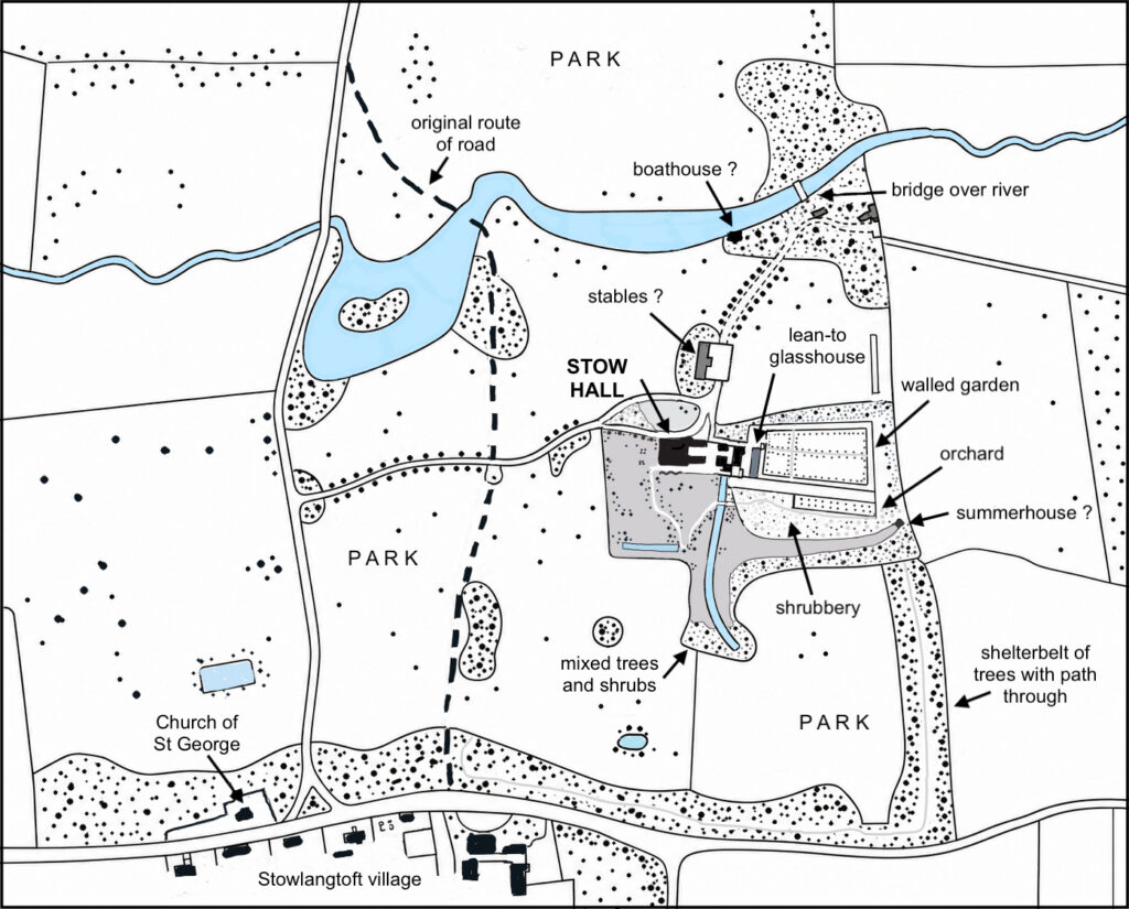
A western gateway gave access to the walled kitchen garden from the house. It measures c. 80m x 30m (262ft x 98ft) with red brick walls c. 3.5m (11.4ft) high. The walls are dated to 1829 when the home of Joseph Wilson. However, most of the west wall appears to have been built or rebuilt later in 1862, marked by inscriptions along the wall of that date and the initials ‘HW’ for Joseph’s son Henry. A number of architectural fragments dated from several periods, including a wrought-iron tie rod dated 1664 with the initials of Sir Willoughby D’Ewes (d. 1685), fourteenth and fifteenth century limestone carving and sections of terracotta window mullions, finials or chimney shafts, that may have come from the old hall when it was demolished are incorporated into the walls.
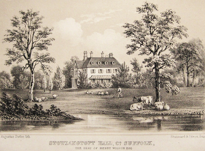
A lithograph in J. B. Burke’s A Visitation of Seats and Arms of the Noblemen and Gentlemen of Great Britain, published in 1852, shows the old hall set in a wooded parkland with sheep and cows grazing beside the nearby river. By this time Henry Wilson had inherited the Stowlangtoft Estate from his father Joseph and the new hall had yet to be built. Around this time the gardens of Stow Hall are said to have had a viewing mount with winding path to the summit beside a pond, although its precise location is unclear.
A coloured image of the gardens at Stowlangtoft appeared in Edward Adveno Brooke’s The Gardens of England, published in 1856, that is believed to be based on the author’s own painting. Brooke (1821–1910) was one of the lesser known landscape painters of the period who occasionally painted scenes of Victorian gardens. The romantic image shows a flat area of lawn surrounded by a path where two women and a woman and child are taking a stroll. Established ornamental trees and shrubs dot the grass where gardeners are working beside a wheelbarrow. Another person, his dress suggesting the head gardener, is depicted with potted plants and a spade close to the edge of the lawn. This is flanked by a tall hedge to one side, conservatory or summerhouse to the other and with an established shrubbery in the foreground. In the distance the ground rises forming a low hill. Based on the date of publication and the terrain, the romantic image must be of the established gardens of Stow Hall and not Stowlangtoft Hall, which was built three years later.
The old Stow Hall was pulled-down or burnt down sometime before 1859, to be replaced by the present Stowlangtoft Hall. An early-eighteenth century marble fireplace incorporated into the new house may have come from Stow Hall. Other material from the site, such as panelled doors, sash windows, shutters, staircases, tiles, etc, was put up for auction in 1860 with notification appearing in the Bury Free Press on the 18 August.
STOWLANGTOFT HALL
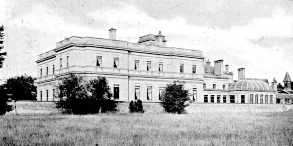
A design for a new house by David Mocatta (1806–82) dated 1845 was not executed. Instead the present Italianate-style Stowlangtoft Hall was built in 1859 to designs by the architect H. Hakewill for Henry Wilson. The principal builders were Messrs Cubitt of Grays End Road in London. Of white Woolpit brick with limestone dressings, its entrance through a portico of limestone is on the north side and the southern garden elevation has a surviving attached five-window loggia leading to a domed roofed conservatory to the east end.

A prominent four-stage tower survives to the north-east of the house and behind is an extensive range of service buildings. These were built to match the Italianate-style of the house and ranged around a courtyard that is entered through a gatehouse and include the stables and coach-houses (Grade II), which were noted in the Norfolk Chronicle, 24 November, 1860 as still under construction. In addition there is a prominent clock tower and attached dovecote.
THE MID-NINETEENTH AND TWENTIETH CENTURY PARK AND GARDENS
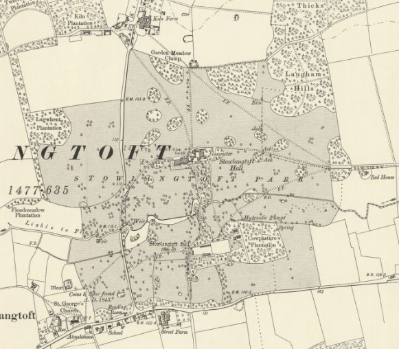
The 1838 highways diversion resulted in the previous public road running east to west from Langham Hall becoming a private routeway within Stowlangtoft Park. This enabled the site of the new Stowlangtoft Hall to have private entrance drives from both the east, where a surviving lodge lies in the village of Langham and outside the park boundary, and the main west entrance off Kiln Lane that appears to have never had an entrance lodge. This set the scene for the expansion of the park to ultimately surround the new Stowlangtoft Hall by taking in arable fields to the north.
The Wilson family continued to develop the parkland during the mid- to late-nineteenth century so that by 1884 the park was bounded by plantations such as ‘Garden Meadow Clump’ to the north and an extension of the existing ‘Langham Hills’ plantation to the north-east. Clumps of trees of various sizes developed in the northern parkland with mainly freestanding specimen trees between the house and the river. At this time Stowlangtoft was renowned for its estate shoot and played host to a number of notable guests, including HRH Edward the Prince of Wales, later King Edward VII, during the late 1800s and early 1900s, by which time the park had expanded further to the west.
With the building of the new Stowlangtoft Hall, the walled and pleasure gardens of the old Stowe Hall site were remote from the house, but linked by the development of a winding paths through pleasure gardens that crossed the east end of the ornamental lake. In 1880 these were said by the Revd F. O. Morris in his A Series of Picturesque Views of Seats of Noblemen and Gentlemen of Great Britain and Ireland to have been laid out by a Mr Page of Southampton. This was William Bridgewater Page (1789–1871), nurseryman, seedsman and landscape gardener of Hill Nursery, Millbrook, Hants. The Revd Norris described the new hall site as: ‘The house stands upon a gentle slope to the south, with cheerful home views all round; it has a raised terrace on the south and west fronts, that on the south being two hundred and sixty feet [80m] in length, with a lower terrace laid out as an Italian garden, whence a path leads to the gardens which belonged to the old house, now some little distance off.’
The 1884 OS map shows the raised terraced gardens around the west and south side of the new hall and Mr Page’s linking pleasure gardens with winding paths crossing the lake at two bridging points and continuing to the old hall site. Here part of the gardens associated with the old house survived, including the thin north to south watercourse and walled kitchen garden. By this time a lean-to glasshouse was attached to the inside of its north wall and another on the outside of the south wall. An additional enclosure, presumably a further kitchen garden, had been created east of the walled garden that had perimeter and cross-paths with fruit trees beside the perimeter path. This was surrounded by a newly-created mixed planting of deciduous and coniferous trees that merged with the older ‘Cowpasture Plantation’ further east.
The Stowlangtoft Estate itself now comprises c. 404ha (1,000a) of parkland, woodland and arable fields. It is managed by the present owners, who have in recent years embarked on a number of conservation projects, such as hedge planting and the creation of a conservation area whilst continuing the successful game shooting on the estate.
Although today still run as a care home with the necessary internal alterations, much of the grandeur of the nineteenth century Stowlangtoft Hall has survived. In recent times the service buildings have been converted into residential properties, including holiday lets, that are served by a new drive from the north-west. The raised terraced gardens to the west and south of Stowlangtoft Hall survive, although, whilst the lower terrace survives in a degraded condition, its associated Italian-style gardens have now gone.
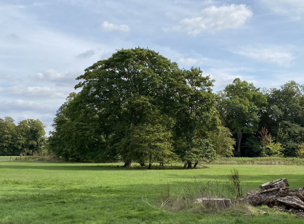
The 2.8ha (7a) of gardens are surrounded by traditional pasture and parkland, although much of the nineteenth century park has reverted back to arable fields. Many nineteenth century blocks of trees survive, including a splendid redwood plantation and the parkland has many mature specimen trees, predominantly oak but also lime, beech and horse chestnut.
Although remnants of William Page’s nineteenth-century linking pleasure gardens survive, the connection between the house and the surviving remote walled garden has mainly been lost since it was sold into separate ownership. The lake and island also survive and the ‘ghost’ of the earlier pleasure grounds of Stowe Hill can be seen from the air, as can the route of the perimeter and cross-paths of the eastern kitchen garden extension that have been shown as parchmarks under grass on aerial photographs.
SOURCES:
Barker, H. R., West Suffolk Illustrated, 1907.
Brooke, Edward Adveno, The Gardens of England, 1856.
Burke, J. B., A Visitation of Seats and Arms of the Noblemen and Gentlemen of Great Britain, 1852.
Bury Free Press, 18 August 1860, notification of auction of building materials.
Cromwell, Thomas, Excursions in the County of Suffolk, Vol. I, 1818.
Foster, Joseph, The Peerage, Baronetage, and Knightage of the British Empire, 1880.
Halliwell, J. O., The Autobiography and correspondence of Sir Simonds D’Ewes, Vol. I and II, 1845. Sir Simonds D’Ewes writing in 1624.
Kelly’s Directory of Cambridge, Norfolk and Suffolk 1922.
Kirby, John, The Suffolk Traveller, 1764.
Morris, Revd F. O., A Series of Picturesque Views of Seats of Noblemen and Gentlemen of Great Britain and Ireland, Vol. 3, 1880.
Norfolk Chronicle, 24 November, 1860.
Sandon, Eric, Suffolk Houses. A Study of Domestic Architecture, 1977.
Shoberi, Frederic, Suffolk, or, Original delineations, topographical, historical, and descriptive of that county, 1818.
The Field, 23 April 1887.
Williamson, Tom, Suffolk’s Gardens & Parks, 2000.
https://www.breretonworld.com/2020/04/joseph-wilson.html (accessed May 2026).
http://www.harpenden-history.org.uk/page/i_rang_a_doorbell_in_colchester_and_a_door_opened_in_harpenden
(accessed May 2021).
http://stowlangtoft.onesuffolk.net/home/history/ Stowlangtoft Parish History (accessed May 2021).
http://landedfamilies.blogspot.com/2016/02/205-ashfield-of-stow-hall-and-eastwood.html (accessed 2016).
https://stowhealthcare.co.uk/care-homes/stowlangtoft-hall/ (accessed May 2026).
https://stowlangtoftestate.co.uk/ (accessed May 2026).
Keeper, Mike, 2014, http://stowlangtoft.onesuffolk.net/home/st-george-s-church/samuel-rickards-rector/ (accessed June 2021).
https://www.ribapix.com/ RIBA Drawing Collection, No: 95734.
www.stowlangtoftestate.co.uk (accessed April 2021).
https://www.burypastandpresent.org.uk/spanton-jarman-project/ Bury St Edmunds Past and Present Society website.
Historic England assessment for inclusion onto the Register of Historic Parks and Gardens for its special historic interest, which failed the criteria for registration. https://www.heritagegateway.org.uk/Gateway/Results_Single.aspx?uid=1489545&resourceID=7 (accessed November 2025)
Census: 1841, 1851, 1861, 1871, 1881, 1891, 1901, 1911.
Maps:
1783 Hodskinson’s Map of Suffolk in 1783.
1824 J. G. Lenny estate map.
1837 Ordnance Survey map.
1848 tithe map and apportionment.
1884 (surveyed 1882 to 1883) OS map.
1905 (revised 1903) OS map.
1952 (revised 1950) OS map.
Heritage Assets:
Suffolk Historic Environment Record (SHER): No: SFT 002, SFT 017.
Stowlangtoft Hall (Grade II). Historic England No: 1032423.
Stables and coach-houses 50 metres north-east of Stowlangtoft Hall (Grade II). Historic England No: 1182834.
Walled Garden, 370 metres south of Stowlangtoft Hall… (Grade II). Historic England No: 1032424.
Suffolk Archives (previously Suffolk Record Office):
(SA) HA530/3/1. Plan of original estate, 13 May 1818.
(SA) HA530/2/9/2/1. Papers related to purchase, 1825.
(SA) BA 500/FA/Q/SH 1-121, Highway diversion orders, plans and related papers. Surveyor Philip Baker, June 1838.
(SA) FL522/13/1/9/ Sales particulars, 1911.
(SA) HC539/B/1/2. Sales particulars of contents, 1920.
Site ownership: Private
Study written: May 2026
Type of Study: Desktop and viewing from public access areas September 2022, April 2023.
Written by: Tina Ranft with additional information by Elizabeth Adams and Gillian Childs
Amended:
